Search Results
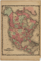
Map of North America, circa 1863
Date
1861 to 1865
Description
Scale [ca. 1:15,840,000. 1 inch to approx. 250 miles] (W 167°- -W27°/N 85°--N 10°) ; 1 map : hand col. ; 53 x 40 cm ; Hand colored ; Prime meridians: Greenwich and Washington, D.C. ; Includes mail routes and proposed railroad routes; Has decorative border ; Plates 15 and 16 from Johnson's new illustrated family atlas of the world ; Partial geographical index on verso ; Alternate title: North America Johnson and Ward
Text

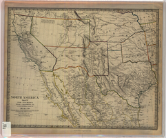
Map of Utah, New Mexico, Texas, California, Indian territory, and the northern states of Mexico, 1852
Date
1852-01-01
Description
At head of title: 'North America, sheet XV.' 'Published under the superintendence of the Society for Diffusion of Useful Knowledge.' At bottom center of map:'London, Charles Knight, Jany. 1st, 1852.' At bottom right of map: ' J. & C. Walker Sculpt.' Scale [1:7,500,000] 1 degree to 68.89 English miles (W 125°--W 92°/N 43°30?--N 22°30?). Relief shown by hachures. Atlas page number in lower margin: 144. Boundaries hand colored. Includes notes, locations of Indian tribes, population statistics. Charles Knight.
Image
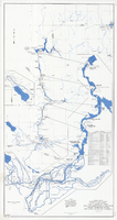
Map and operational diagram, lower Colorado River, Lees Ferry to Gulf of California, June 1973
Date
1973-06
Description
84 x 43 cm. "Map no. 423-300-59." Insets: [Salton Sea]--Operational diagram, no scale. Includes index to gaging stations. Shows dams, canals, levees, pumping plants, etc. "Map compiled from Coast and Geodetic Survey sectional aeronautical charts, and Bureau of Reclamation data." Original publisher: U.S. Dept. of the Interior, Bureau of Reclamation.
Image
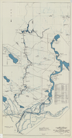
Map and operational diagram, lower Colorado River, Lees Ferry to Gulf of California, May 1957
Date
1957-05
Description
83 x 43 cm. "Drawing no. 423-300-59." "May 1957." "Supercedes 423-306-183." "Map compiled from Coast and Geodetic Survey sectional aeronautical charts, and Bureau of Reclamation data." Includes index to gaging stations. Shows dams, canals, levees, pumping plants, etc. Insets: [Salton Sea]--Operational diagram, no scale. "Revised June 1967." Original publisher: Bureau of Reclamation, Region 3.
Image
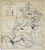
Map of Colorado River Basin, 1928
Date
1928
Description
52 x 46 cm. "Map no. 23000." Shows reservoir sites, irrigated areas, power plants, power sites, dam sites, national parks or monuments, and diversion from basin. Colorado River Basin/Department of the Interior, Bureau of Reclamation; John H. Pellen, chief draftsman. Original publisher: United States. Bureau of Reclamation.
Image
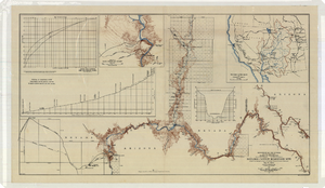
Topographic map of the Boulder Canyon Reservoir site, 1930
Date
1930
Description
Scale [ca. 1:144,000. 1 in. to approx. 12,000 ft.] ; 1 map : col. ; 51 x 91 cm ; Relief shown by contours and spot heights ; "Map no. 23800" ; Includes township and range grid ; Includes two profile diagrams, area and capacity curve diagram, Topography of Black Canyon and vicinity map and Colorado River basin map. Inset maps of Black Canyon and vicinity and Colorado River Basin. Inset charts of Boulder Canyon Reservoir Area and Capacity Curves; and, Profile of Colorado River from Bridge Canyon Dam Site, Arizona to Black Canyon Dam Site, Arizona-Nevada. Bureau of Reclamation.
Image