Search Results
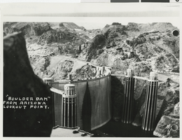
Photograph of Boulder Dam (Hoover Dam), 1940s
Date
1940 to 1949
Archival Collection
Description
Black and white photograph of Lake Mead and Boulder Dam (now called Hoover Dam). View of Boulder Dam from Arizona lookout point. Possibly a postcard.
Image
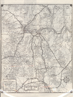
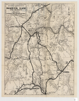
Road map of Hoover Dam and vicinity, circa 1949
Date
1947 to 1951
Description
'Cartography by W. C. Kainsinger, W.T. Taylor. Field mapping by K. R. Reed, G. Boyd. Typography by W. R. Williams.' 'Copyright by Automobile Club of Southern California. C-21351.' 'C-1352'--Panel. Index on verso. In lower right corner: 'Map number 1959.' Scale 1:415,210 (W 116°--W 114°/N 37°--N 35°). Relief shown by hachures and spot heights. Shows mines, ranches and springs. Not the same as the 1948 edition of this map. Cartographers', field mappers', typographers' names are different, and 2 out of 3 numbers on maps are different. Probably after 1947 as Boulder Dam has been changed to Hoover Dam, but before 1950 as Las Vegas Bombing and Gunnery Range has not been changed to Nellis Air Force Base. Automobile Club of Southern California.
Text
Hoover Dam (Boulder Dam): postcards, 1936
Level of Description
File
Archival Collection
Edith Giles Barcus Family Photograph Collection
To request this item in person:
Collection Number: PH-00117
Collection Name: Edith Giles Barcus Family Photograph Collection
Box/Folder: Folder 01
Collection Name: Edith Giles Barcus Family Photograph Collection
Box/Folder: Folder 01
Archival Component
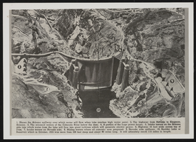
Photograph of view of Boulder Dam, Hoover Dam, December 4, 1939
Date
1939-12-04
Archival Collection
Description
Colorado River-Hoover Dam. Views of Boulder Dam printed in book or magazine; numbers on the photo correspond to particular areas described at the bottom of the image. Site Name: Hoover Dam (dam)
Image
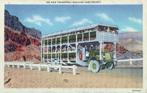
Postcard showing a 150 man transport for the Boulder Dam Project, Hoover Dam, circa 1930s
Date
1930 to 1939
Archival Collection
Description
A colored postcard showing an artist's representation of an 150 man transport for the Boulder Dam, later renamed Hoover Dam, project in Black Canyon. Transcribed onto the top border of the image: "150 Man Transport, Boulder Dam Project."
Image
Map showing automobile routes to Hoover Dam and vicinity, circa 1934
Date
1930 to 1938
Description
'Prepared by the Automobile Club of Southern California.' 'burke' in lower right corner. '1352' in circle in lower left corner. Relief shown by hachures and spot heights. Shows mines, ranches, and springs. Scale [ca. 1:443,520] (W 115°30--W 114°--N 36°30/N 35°)
Image
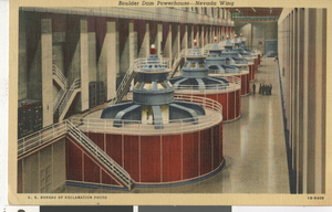
Postcard of Boulder Dam Powerhouse machines, Hoover Dam (Nev.), 1934-1935
Date
1934 to 1935
Description
Boulder Dam Powerhouse, Nevada wing (postcard)
Image
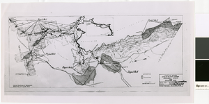
Map of irrigable areas near Boulder Dam, February 20, 1935
Date
1935-02-20
Archival Collection
Description
'Drawn by C.G.C.' 'Carson City, Nevada, Feb. 20, 1935. No. 4.' 'Adapted from Bureau of Reclamation's General map of irrigable areas.'
Image