Search Results
Aerial image of excavation site near present-day Stephanie Street in Henderson, Nevada: photographic print, approximately 1997 to 2002
Level of Description
Archival Collection
Collection Name: Brian Jones Collection of Henderson, Nevada Aerial Photographs
Box/Folder: Box SH-049
Archival Component
Henderson Nevada Lake Mead Stake; Fairvew, Pueblo, and Calico Ridge wards, parking lot rebuilding, 2000 July 18
Level of Description
Archival Collection
Collection Name: Alton Dean Jensen Architectural Records
Box/Folder: Box 270
Archival Component
Henderson Nevada Lake Mead Stake; Fairvew, Pueblo, and Calico Ridge wards, new parking lot, 2002 March 12
Level of Description
Archival Collection
Collection Name: Alton Dean Jensen Architectural Records
Box/Folder: Box 270
Archival Component
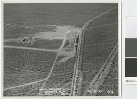
Aerial photograph showing railroad siding and water storage tanks, Basic Magnesium Inc., Henderson, Nevada, October 8, 1941
Date
Archival Collection
Description
Aerial view looking east that shows the temporary rail siding and water storage tanks south of the Basic Magnesium Inc. site.
Transcribed Notes: Transcribed from front of photo: "McNeil construction Co. Magnesium plant, Las Vegas, Nevada, 10-8-41"
Image

Cars travel on Siena Heights Drive off Eastern Avenue, looking south-southwest in Henderson, Nevada: digital photograph
Date
Archival Collection
Description
From the UNLV University Libraries Photographs of the Development of the Las Vegas Valley, Nevada (PH-00394). Part of the collection documents the entire 19 mile length of the north/south Eastern Avenue / Civic Center Drive alignment. This photograph was captured in the section of Eastern Avenue between Silverado Ranch Boulevard and Coronado Center Drive.
Image
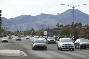
Traffic flows down Eastern Avenue near Coronado Center Drive, looking southeast in Henderson, Nevada: digital photograph
Date
Archival Collection
Description
From the UNLV University Libraries Photographs of the Development of the Las Vegas Valley, Nevada (PH-00394). Part of the collection documents the entire 19 mile length of the north/south Eastern Avenue / Civic Center Drive alignment. This photograph was captured in the section of Eastern Avenue between Silverado Ranch Boulevard and Coronado Center Drive.
Image
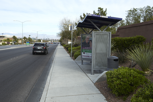
A bus shelter on Eastern Avenue near Coronado Center Drive, looking north-west in Henderson, Nevada: digital photograph
Date
Archival Collection
Description
From the UNLV University Libraries Photographs of the Development of the Las Vegas Valley, Nevada (PH-00394). Part of the collection documents the entire 19 mile length of the north/south Eastern Avenue / Civic Center Drive alignment. This photograph was captured in the section of Eastern Avenue between Silverado Ranch Boulevard and Coronado Center Drive.
Image
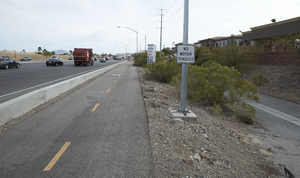
The St. Rose Parkway Trail at Eastern Avenue and St. Rose Parkway, looking northeast in Henderson, Nevada: digital photograph
Date
Archival Collection
Description
From the UNLV University Libraries Photographs of the Development of the Las Vegas Valley, Nevada (PH-00394). Part of the collection documents the entire 19 mile length of the north/south Eastern Avenue / Civic Center Drive alignment. This photograph was captured in the section of Eastern Avenue between Silverado Ranch Boulevard and Coronado Center Drive.
Image
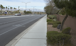
Landscaping near the intersection of Eastern Avenue and St. Rose Parkway, looking west-northwest in Henderson, Nevada: digital photograph
Date
Archival Collection
Description
From the UNLV University Libraries Photographs of the Development of the Las Vegas Valley, Nevada (PH-00394). Part of the collection documents the entire 19 mile length of the north/south Eastern Avenue / Civic Center Drive alignment. This photograph was captured in the section of Eastern Avenue between Silverado Ranch Boulevard and Coronado Center Drive.
Image
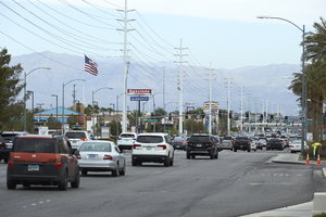
Traffic flows from Eastern Avenue and Silverado Ranch Boulevard, looking north-northwest in Henderson, Nevada: digital photograph
Date
Archival Collection
Description
From the UNLV University Libraries Photographs of the Development of the Las Vegas Valley, Nevada (PH-00394). Part of the collection documents the entire 19 mile length of the north/south Eastern Avenue / Civic Center Drive alignment. This photograph was captured in the section of Eastern Avenue between Silverado Ranch Boulevard and Coronado Center Drive.
Image