Search Results
Aerial image of housing tracts in Green Valley area in Henderson, Nevada: photographic print, approximately 1997 to 2002
Level of Description
Archival Collection
Collection Name: Brian Jones Collection of Henderson, Nevada Aerial Photographs
Box/Folder: Box SH-049
Archival Component
Henderson Nevada Stake; River Mountain, Palo Verde, and Heritage Wards, project manual, 1998 August 24
Level of Description
Archival Collection
Collection Name: Alton Dean Jensen Architectural Records
Box/Folder: Box 270
Archival Component

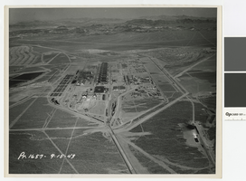
Aerial photograph of Basic Magnesium Incorporated facility, southward direction, Henderson, Nevada, September 15, 1943
Date
Archival Collection
Description
Aerial view of Basic Magnesium plant from the north
Image
Aerial photograph of Basic Magnesium Incorporated facility, eastward direction, Henderson, Nevada, September 15, 1943
Date
Archival Collection
Description
Aerial view of Basic Magnesium plant from the west
Image
Winslow, Arizona and Basic Magnesium, Inc., Henderson, Nevada: photographic prints and negatives, approximately 1890 to 1943
Level of Description
Archival Collection
Collection Name: Victor Kunkel Photograph Collection
Box/Folder: Folder 01, Folder 02, Folder 03, Folder 04, Oversized Box SH-056, Box SH-020 (Restrictions apply)
Archival Component

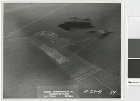
Aerial photograph showing plant site excavation, Basic Magnesium, Inc., Henderson, Nevada, October 8, 1941
Date
Archival Collection
Description
Aerial view looking east showing the Basic Magnesium Inc. plant site shortly after excavation began.
Transcribed Notes: Transcribed from front of photo: "McNeil construction Co. Magnesium plant, Las Vegas, Nevada, 10-8-41"
Image

Aerial photograph of Basic Magnesium Inc. plant site, Henderson, Nevada, and Pittman, Nevada, October 8, 1941
Date
Archival Collection
Description
Air view looking north showing the Basic Magnesium Inc. plant site temporary administration building, temporary water tanks and railroad siding.
Transcribed Notes: Transcribed from front of photo: "McNeil construction Co. Magnesium plant, Las Vegas, Nevada, 10-8-41"
Image
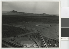
Aerial photograph showing the Basic Magnesium Inc. plant site, Henderson, Nevada, October 29, 1941
Date
Archival Collection
Description
Air view showing Basic Magnesium Inc. plant site excavation with the administration building in foreground, looking southeast to Railroad Pass.
Transcribed Notes: Transcribed from front of photo: "McNeil construction Co. Magnesium plant, Las Vegas, Nevada, 10-29-41"
Image
Aerial photograph showing temporary boarding camp, Basic Magnesium Inc., Henderson, Nevada, December 8, 1941
Date
Archival Collection
Description
Aerial view of temporary camp for Basic Magnesium Inc. construction workers looking northeast towards Frenchman Mountain.
Transcribed Notes: Transcribed from front of photo: "McNeil construction Co. Magnesium plant, Las Vegas, Nevada, 12-8-41"
Image
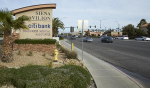
Landscaping and commercial development along Eastern Avenue, looking west-northwest in Henderson, Nevada: digital photograph
Date
Archival Collection
Description
From the UNLV University Libraries Photographs of the Development of the Las Vegas Valley, Nevada (PH-00394). Part of the collection documents the entire 19 mile length of the north/south Eastern Avenue / Civic Center Drive alignment. This photograph was captured in the section of Eastern Avenue between Silverado Ranch Boulevard and Coronado Center Drive.
Image