Search Results
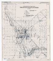
Map of part of Las Vegas Valley showing contours of the composite piezometric surface during the spring of 1944, and specific capacities of wells tapping the confined water
Date
Description
Relief shown by contours. Includes range and township grid. Shows springs and wells. Scale [ca. 1:67,162. 1 in. to approx. 1.06 miles]. Series: Water resources bulletin (Carson City, Nev.)
no. 5. Originally published as plate 8 in Geology and water resources of Las Vegas, Pahrump, and Indian Spring Valleys, Clark and Nye Counties, Nevada by George B. Maxey and C.H. Jameson, which is number 5 of the Water resources bulletin published by the Nevada Office of the State Engineer.
Image
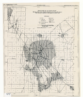
Map of part of Las Vegas Valley showing the piezometric surface of the "near-surface" water during the spring of 1946 by contours, and areas of discharge by evaporation and transpiration
Date
Description
Relief shown by contours. Includes range and township grid. Shows springs, wells and areas of discharge. Scale [ca. 1:67,162. 1 in. to approx. 1.06 miles]. Series: Water resources bulletin (Carson City, Nev.)
no. 5. Originally published as plate 7 in Geology and water resources of Las Vegas, Pahrump, and Indian Spring Valleys, Clark and Nye Counties, Nevada by George B. Maxey and C.H. Jameson, which is number 5 of the Water resources bulletin published by the Nevada Office of the State Engineer.
Image
Letter from Walter R. Bracken (Las Vegas) to W. M. Jeffers, November 13, 1944
Date
Archival Collection
Description
The Chamber of Commerce agreed that the artesian water in the valley should be reserved for domestic purposes, and Lake Mead water for irrigation, but Bracken wrote that this was academic because Basic Magnesium Inc. had no excess water.
Text
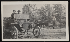
Photograph of Jake and Alta Beckley, Sierra Vista (Ariz.), 1915
Date
Archival Collection
Description
Image
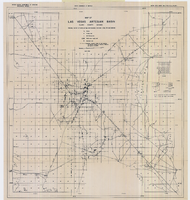
Map of Las Vegas artesian basin, Clark County, Nevada, April 1946 (Water Resources Bulletin no. 4, plate 1)
Date
Description
Image

Map of Las Vegas Valley artesian basin, circa 1940
Date
Description
Image