Search Results
Aerial view of the Hoover Dam site on the Colorado River at Black Canyon, southern Nevada, courtesy of Fairchild Aerial Surveys, California: photographic print, 1930 June 27
Level of Description
File
Archival Collection
Franklin M. Murphy Photograph Collection
To request this item in person:
Collection Number: PH-00232
Collection Name: Franklin M. Murphy Photograph Collection
Box/Folder: Folder 01
Collection Name: Franklin M. Murphy Photograph Collection
Box/Folder: Folder 01
Archival Component
Rafting the Grand Canyon; Grand Canyon aerial views; "Good Morning America" segment on Hoover Dam; Lake Las Vegas samples and aerial views, 1990 to 1994
Level of Description
File
Archival Collection
Gene Hertzog Professional Papers
To request this item in person:
Collection Number: MS-01015
Collection Name: Gene Hertzog Professional Papers
Box/Folder: Box 20
Collection Name: Gene Hertzog Professional Papers
Box/Folder: Box 20
Archival Component
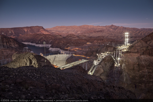
Photograph of the Mike O'Callaghan-Pat Tillman Memorial Bridge during construction, Hoover Dam, and Lake Mead at dusk, Nevada-Arizona border, October 21, 2009
Date
2009-10-21
Archival Collection
Description
Photographer's notes: "A view of the bridge, dam and Lake Mead at dusk. Pier and pier cap construction can be seen along the length of the arch." Site Name: Mike O'Callaghan-Pat Tillman Memorial Bridge
Image
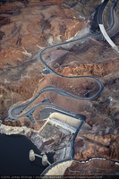
Photograph showing an aerial view of the original winding road descending to Hoover Dam with the new bypass road under construction in the upper right, Arizona border, February 3, 2010
Date
2010-02-03
Archival Collection
Description
Photographer's notes: "Aerial view of the winding original road descending to the dam on the Arizona side with the new bypass road under construction in the upper right, February 3, 2010." Site Name: Mike O'Callaghan-Pat Tillman Memorial Bridge
Image
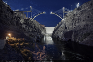
Photograph showing an upstream view of Hoover Dam and the Mike O'Callaghan-Pat Tillman Memorial Bridge under construction, Nevada-Arizona border, May 21, 2009
Date
2009-05-21
Archival Collection
Description
Photographer's notes: "Upstream view of the bridge and dam. The growing arch segments on the Nevada and Arizona sides of the canyon moved toward their rendezvous over the Colorado River." Site Name: Mike O'Callaghan-Pat Tillman Memorial Bridge
Image

Photograph showing a partial side view of the Mike O'Callaghan-Pat Tillman Memorial Bridge near power lines and towers at Hoover Dam, January 13, 2011
Date
2011-01-13
Archival Collection
Description
Photographer's notes: "A return to the view of the bridge from the dam sidewalk first taken in April 2009. January 13, 2011." Site Name: Mike O'Callaghan-Pat Tillman Memorial Bridge
Image
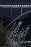
Photograph showing a partial side view of the Mike O'Callaghan-Pat Tillman Memorial Bridge near power lines and towers at Hoover Dam, January 13, 2011
Date
2011-01-13
Archival Collection
Description
Photographer's notes: "A return to the view of the bridge from the dam sidewalk first taken in April 2009. January 13, 2011." Site Name: Mike O'Callaghan-Pat Tillman Memorial Bridge
Image
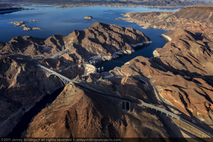
Photograph showing an aerial view of the Mike O'Callaghan-Pat Tillman Memorial Bridge, Hoover Dam, and Lake Mead, Nevada-Arizona border, January 14, 2011
Date
2011-01-14
Archival Collection
Description
Photographer's notes: "With the bridge complete and open, the bridge, dam and lake now share the Black Canyon." Site Name: Mike O'Callaghan-Pat Tillman Memorial Bridge
Image
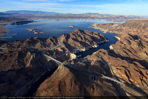
Photograph showing an aerial view of the Mike O'Callaghan-Pat Tillman Memorial Bridge, Hoover Dam, and Lake Mead, Nevada-Arizona border, January 14, 2011
Date
2011-01-14
Archival Collection
Description
Photographer's notes: "With the bridge complete and open, the bridge, dam and lake now share the Black Canyon. January 14, 2011. Note: This is the uncropped version of this photograph. I chose to crop out the horizon for use in the book and exhibition." Site Name: Mike O'Callaghan-Pat Tillman Memorial Bridge
Image
Ironworkers being transported in manbaskets during Mike O'Callaghan-Pat Tillman Memorial Bridge construction near the Arizona side of Hoover Dam, 2009 April 29
Level of Description
File
Archival Collection
Jamey Stillings Photographs
To request this item in person:
Collection Number: PH-00380
Collection Name: Jamey Stillings Photographs
Box/Folder: Digital File 00
Collection Name: Jamey Stillings Photographs
Box/Folder: Digital File 00
Archival Component