Search Results
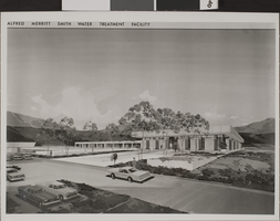
Photograph of Water Treatment Facility, Las Vegas, circa late 1960s-1971
Date
1965 to 1971
Archival Collection
Description
An artist's rendering of the Alfred Merritt Smith Water Treatment Facility in Las Vegas, Nevada.
Image
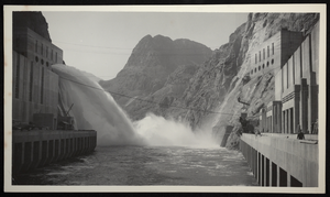
Photograph of water discharging from jet flow gates, Hoover Dam, circa 1934-1936
Date
1934 to 1936
Archival Collection
Description
An image of men on the Arizona side of Boulder Dam watching as water discharges from the Nevada side jet flow gates (outlet works). The name was officially changed to Hoover Dam in 1947.
Image
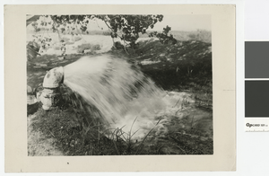
Photograph of artesian well throwing 60 inches of water, after 1950
Date
1950 to 1960
Archival Collection
Description
Man opening a valve to let an artesian well run
Transcribed Notes: Stamped on back: Vegas Studio, Las Vegas, Nevada; Handwritten inscription on back: Artesian well throwing 60 inches of water. Artesian wells average 400 ft. deep.
Image
Water (Southern Nevada Water Project). Contains correspondence, press releases, booklets, news clippings, reports and memos, 1967 November to 1969 October
Level of Description
File
Archival Collection
Howard Cannon Papers
To request this item in person:
Collection Number: MS-00002
Collection Name: Howard Cannon Papers
Box/Folder: Box 69 (91st Session)
Collection Name: Howard Cannon Papers
Box/Folder: Box 69 (91st Session)
Archival Component

Topographic map of groundwater in the southwest quadrangle of Las Vegas, Nevada, 1985
Date
1985
Description
'Las Vegas Area Map 3Bf.' 'Prepared in cooperation with the U.S. Geological Survey.' ' Water Resources Division, U.S. Geological Survey, Carson City, Nevada.' Scale 1:24,000 (W 115°15´00?--W 115°07´30? / N 36°07´30?--N 36°00´00?). Series: Las Vegas area map ; 3Bf. Urban area maps. Las Vegas area map ; 3Bf. Relief shown by contour lines and spot heights. Title in right and left margins: Las Vegas SW quad : ground water. Title on publications list on Nevada Bureau of Mines and Geology website: Groundwater map of the Las Vegas SW quadrangle. Series: Urban area maps [Las Vegas area map] from list of publications on Nevada Bureau of Mines and Geology website. Nevada Bureau of Mines and Geology
Text
Letter from General Counsel (Las Vegas) to H. I. Bettis regarding Las Vegas water system maintenance, Dec. 11, 1906
Date
1906-12-11
Archival Collection
Description
General Counsel recommends an examination of the water rights and water properties embraced in the mortgage, and an examination of the title deeds before the railroad company makes any real estate decisions.
Text
Las Vegas water shortage newspaper clippings, 1950 to 1951
Level of Description
File
Archival Collection
Las Vegas Land & Water Company Records from the Las Vegas Valley Water District
To request this item in person:
Collection Number: MS-00912
Collection Name: Las Vegas Land & Water Company Records from the Las Vegas Valley Water District
Box/Folder: Box 03
Collection Name: Las Vegas Land & Water Company Records from the Las Vegas Valley Water District
Box/Folder: Box 03
Archival Component
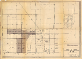
Plan of lands proposed to be purchased by the Las Vegas Valley Water District, August 1, 1952
Date
1952-08-01
Archival Collection
Description
'Date: August 1, 1952. Approved, Thomas A. Campbell, Pres.' Scale: [1 in.=approx. 300 feet]. Library's copy 2 has additional areas shaded, with original shaded areas outlined in red, plus various handwritten notations in pencil.
Image
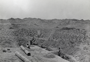
Photograph of water pipe being laid near Boulder City, Nevada, 1931
Date
1931
Archival Collection
Description
Laying pipe for Boulder City's water supply near Boulder City, Nevada . (1931)
Image
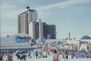
Slide of people at the Wet 'n' Wild water park, Las Vegas, circa 1990
Date
1990 to 1995
Archival Collection
Description
Swimmers at the Wet 'n' Wild water park in Las Vegas. The Sahara Hotel is seen in the background.
Image