Search Results
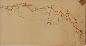
Map of the fourth level of the Clermont Mine, Goldfield, Nevada, circa 1902-1908
Date
1902 to 1908
Description
Hand-drawn, hand-colored and annotated map showing the fourth level of the Clermont Mine. Upper left and lower right corners missing.
Image
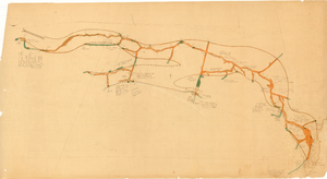
Map of the sixth level of the Clermont Mine, Goldfield, Nevada, circa 1902-1908
Date
1902 to 1908
Description
Hand-drawn, hand-colored and annotated map showing the sixth level of the Claremont Mine. 'Clermont, 6th level, el. 4971.4.'
Image

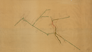
Longitudinal section map, Montana Tonopah Mine, circa 1900s-1910s
Date
1900 to 1919
Description
'Longitudinal Section, Montana Tonopah Mine showing workings projected on east-west vertical plane.' In lower right corner: 'E.D. North E.M.' 'Photo-litho. Britton & Rey, S.F.'
Image
Map of the Goldfield Mining District, Goldfield, Nevada, 1907
Date
1907
Description
'Elmer J. Chute, E.M. and Olmstead and Rich, Goldfield, Nevada. Copyright 1907, by Elmer J. Chute, Goldfield, Nev.' Includes information on and prices for wall and pocket map with this title. Includes inset map. Includes township and range grid. Library's copy has Rochester GF. claim circled in blue ink , has a piece missing to the right of that claim, and has "Mohawk ledge, a lease by Davis & Shoemaker" written in blue ink at the center bottom of the map with a line in blue ink drawn to the Frances Mohawk claim.
Image
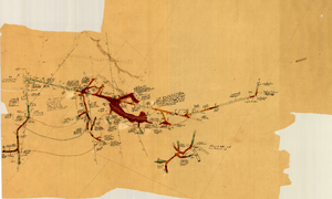
Map of the 280 foot level of the Combination Mine, Goldfield, Nevada, circa 1902-1908
Date
1902 to 1908
Description
Hand-drawn, hand-colored and annotated map showing the 280 foot level of the Combination Mine. Printed on map: 'Mohawk, col. el. 5958.48; Hayes & Monnette No. 2, col. el. 5935.7; Hayes & Monnette No. 1, col. el. 5925.8; Truett, col. el. 5938.8; Combination, col. el. 5986.31.'
Image
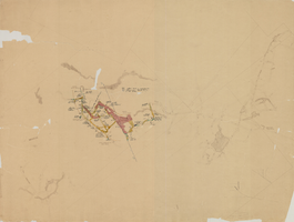
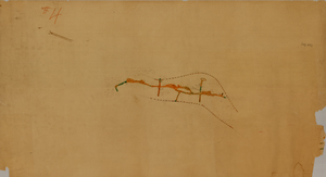
Map of the third level of the Red Top Mine, Goldfield, Nevada, circa 1902-1908
Date
1902 to 1908
Description
'Red Top 3rd level, 5659.90.' Hand-drawn, hand-colored and annotated map showing the third level of the Red Top Mine.
Image
Map of the fourth level of the Red Top Mine, Goldfield, Nevada, circa 1902-1908
Date
1902 to 1908
Description
'Red Top, 4th level. 5586.90.' Hand-drawn, hand-colored and annotated map showing the fourth level of the Rep Top Mine.
Image
Map of the first level of the Red Top Mine, Goldfield, Nevada, circa 1902-1908
Date
1902 to 1908
Description
'Red Top, 1st level. 5820.30.' Hand-drawn, hand-colored and annotated map showing the first level of the Red Top Mine.
Image
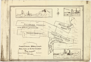
Map of properties in the Tonopah Mining District, Nye County, Nevada, circa 1901
Date
1897 to 1905
Description
'Surveyed by S.K. Bradford, U.S. Deputy.' 'May Bradford, Draughtsman.' Includes locations of mines and their main shafts and drawings of the hoists of the Tonopah Extension, Golden Anchor and the Red Rock Consolidated. Scale [ca. 1:2,400] 1 in. to 200 feet.
Image
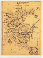
Map of Searchlight mining district, Clark County, Nevada, circa 1905
Date
1901 to 1909
Description
At bottom right of map: 'C.D. Baker, A.R. Thompson.' Title in lower right corner: 'Map of Searchlight mining district: mineral patents, water rights.' Logo of Nevada Engineering Construction Service, Inc., Las Vegas, Nev. in lower right corner. Blueline print. Shows mineral patents and water rights. Nevada Engineering & Construction Service, Inc.
Image