
Search the Special Collections and Archives Portal

Search Results

Display    Results Per Page
Displaying results 3861 - 3870 of 4486

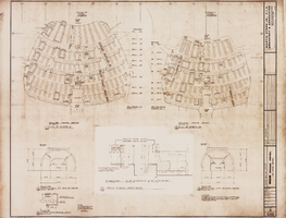
Architectural drawing of the MGM Grand Hotel (Las Vegas), theatre seating layouts, September 11, 1972

Date

1972-09-11

Description

Architectural plans for the MGM Grand Hotel (Las Vegas) from 1972. Printed on mylar. The MGM Grand Hotel was sold to Bally's Corporation to become Bally's Las Vegas in 1985. Berton Charles Severson, architect; Brian Walter Webb, architect; E. C. Garcia, delineator; Taylor Construction Co., Interior Design Division.
Site Name: MGM Grand Hotel
Address: 3645 Las Vegas Boulevard South, Las Vegas, NV

Latest Drawing Revision: 1972-09-11

Image

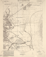
Topographic map of the southwestern quadrangle of the metropolitan Las Vegas, Nevada area, 1973

Date

1973

Description

Scale 1:24,000 ; polyconic proj. (W 115°1500--W 115°0730/N 36°0730--N 36°0000) ; 1 map : col. ; 58 x 47 cm ; 7.5 minute series (topographic) ; Relief shown by contours and spot heights ; Filing title: Las Vegas SW, Nev ; "AMS 2956 II SW--Series V896." ; Contour interval 10 feet ; "Topography by photogrammetric methods from aerial photographs taken 1965. Field checked 1967." ; "Map photoinspected 1973. No major culture or drainage changes observed." ; Includes quadrangle location map ; Interior--Geological Survey

Image

Map showing U.S. Bureau of Reclamation Region 3 projects in Arizona, California, Nevada, New Mexico and Utah, September 1967

Date

1967-09

Description

'United States, Department of the Interior, Stewart L. Udall, Secretary. Bureau of Reclamation, Floyd E. Dominy, Commissioner.' 'Map. No. X-300-738. September 1967.' Scale [ca. 1:1,774,080] (W 119°--W 108°/N 39°--N 32°). Relief shown pictorially. Shows completed, under construction and proposed dams and reservoirs, canals, and aqueducts, power plants, pumping plants, substations, transmission lines, tunnels and siphons. Also shows non-Bureau of Reclamation dams, reservoirs, tunnels, pipelines and irrigated lands. Includes inset map of location of Region 3 and key map of drainage basins. Bureau of Reclamation, [Region 3?].

Image

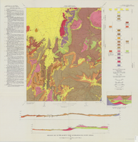
Geologic map of the Quartet Dome quadrangle, Nye County, Nevada, 1966

Date

1966

Description

58 x 46 cm., on sheet 88 x 85 cm., folded in envelope 30 x 24 cm. Relief shown by contours and spot heights. "Contour interval 20 feet." "Base by U.S. Geological Survey, 1962, 10,000-foot grid based on Nevada coordinate system, central zone." "Geology mapped in 1962-63." Includes 2 col. cross sections, diagrammetric stratigraphic section, quadrangle location map, and text. "Prepared in cooperation with the U.S. Atomic Energy Commission." Original publisher: Interior, Geological Survey, Series: Geologic quadrangle map GQ, Scale: 1:24 000.

Image

Las Vegas Paiute Colony land acquisition: correspondence

Date

1970 to 1971

Description

Letter from Rolla E. Chandler, Manager, Nevada Land Office, to Richard Bailey, Inter-Tribal Council Planning Unit and notice of classification of public lands for transfer out of Federal ownership. Letter from Superintendent to Area Director about a resolution/request from the Las Vegas Indian Colony for assistance in securing additional lands through legislation. Letter from Inter-Tribal Council of Nevada attorney Michael Seth Krout to Superintendent of Nevada Indian Agency Jose A. Zuni about Las Vegas Paiute Colony land. Resolution of Las Vegas Council requesting submission of a bill to Congress for holding land in trust. Letter from Inter-Tribal Council of Nevada attorney Michael Seth Krout to the Secretary of the Interior about acquiring additional land for the Las Vegas Paiute Colony.

Text

Maps of flood-prone areas in Las Vegas, Nevada, 1973

Date

1973

Description

'Prepared by the U.S. Department of the Interior, Geological Survey, in cooperation with the U.S. Department of Housing and Urban Development, Federal Insurance Administration. 1973.' Sheet 1: Las Vegas NE, Nev.; Sheet 2: Las Vegas SE, Nev.; Sheet 3:Las Vegas SW, Nev.; Sheet 4: Las Vegas NW, Nev. Published by Geological Survey (U.S.). Scale 1:24,000. [1 in. to approx. 2,000 ft.]. Relief shown by contours. Flood information overprinted on U.S. Geological Survey 7.5 minute topographic quadrangles: [sheet 1] Las Vegas NE quadrangle, [sheet 2] Las Vegas SE quadrangle, [sheet 3] Las Vegas SW quadrangle, [sheet 4] Las Vegas NW quadrangle, 1967. Shows areas subject to flooding by a flood that has 1 in 100 chance on the average of occurring in any one year. "Flood boundaries were estimated from: regional stage-frequency relations." Includes notes.

Image

Schiff, Thomas R.

Thomas R. Schiff studied photography at Ohio University where he earned a Bachelor of Business Administration in 1970. He began experimenting with panoramic photography in the 1980s and in the mid-1990s he started using a Hulcherama 360-degree panoramic camera to take photographs of building exteriors and interiors.

Person

Bergman Walls & Associates

Bergman Walls & Associates (BWA) is an architectural and interior design firm that specializes in hotels, resorts, restaurants, and entertainment. The firm was founded by Joel Bergman and Scott Walls in 1994. The headquarters are located in Las Vegas, but they have offices in Minneapolis, Seattle, and New York City.

Corporate Body