
Search the Special Collections and Archives Portal

Search Results

Display    Results Per Page
Displaying results 3811 - 3820 of 4487

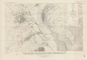
Map of part of Las Vegas Valley, Nevada, showing approximate area and areal densities of phreatophytes and areas in cultivation in 1912

Date

1965

Description

Genre/Form: Thematic maps. Scale 1:62,500 (W 115°15´--W 114°45´/N 36°15´--N 36°00´). 1 map : col. ; 45 x 72 cm. Series: Water-supply paper (Washington, D.C.) ; 1780. Relief shown by contours. Originally published as plate 11 of Available water supply of the Las Vegas ground-water basin, Nevada, by Glenn T. Malmberg, published by the Geological Survey in 1965 as its Water-supply paper 1780. Includes township and range lines. Interior, Geological Survey

Image

Foster, Josephine Gail, 1912-2003

Josephine Gail Johnson was born in Goldfield, Nevada in 1912. Her stepfather, Sam Manor, was a section foreman for the Tonopah and Goldfield Railroad. Because of his position, the family moved to a company house in the town of Millers after the birth of Josephine's younger brother Sam, Jr. in 1920. Josephine and her family evenutually moved to Tonopah. Josephine later married George Byron Foster, and they had two children: Marjorie and Patricia. Josephine Foster passed away March 24, 2003.

Source:

Person

Windsor Court Residence: Rackset, 1987 November 02

Level of Description

File

Scope and Contents

This set includes drawings for Tricon (client) by Daniel P. Smith (engineer).

Archival Collection

Gary Guy Wilson Architectural Drawings
To request this item in person:
Collection Number: MS-00439
Collection Name: Gary Guy Wilson Architectural Drawings
Box/Folder: Roll 592

Archival Component

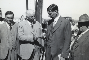
Photograph of Carl Gray handing Ray Lyman Wilbur the first railroad spur spike for Hoover Dam, circa early 1930s

Date

1930 to 1933

Archival Collection

Description

Black and white image of several prominent figures, in front of a crowd outdoors. From left to right: Governor Balzar of Nevada; Carl Gray, President of Union Pacific Railroad Company; Ray Lyman Wilbur, Secretary of the Interior; Governor of Colorado (possibly Edwin C. Johnson). Gray is handing Lyman the first spike to be driven for the spur line to Boulder Dam. Note: Boulder Dam was officially renamed Hoover Dam in 1947.

Image

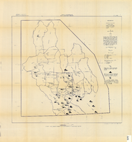
Map showing chemical diagrams representing quality of water in Clark and Nye counties, Nevada, 1963

Date

1963

Description

'T.E. Eakin, S.L. Schoff, and P. Cohen, 1963.' 'Department of the Interior, United States Geological Survey, TEI-833.' 'Prepared in cooperation with the U.S. Atomic Energy Commission.' Scale 1:500,000 (W 117°00´--W 115°00´/N 38°30´--N 36°30´). Originally published as figure 3 in Regional hydrology of a part of southern Nevada : a reconnaissance / by Thomas E. Eakin, Stuart L. Schoff, and Philip Cohen, published by the U.S. Geological Survey in 1963 as number 833 of the Trace elements investigation report.

Image

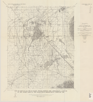
Map of part of Las Vegas Valley, Nevada, showing the approximate altitude of the water table in the near-surface reservoir in February 1956

Date

1965

Description

Genre/Form: Thematic maps. Scale 1:62,500 (W 115°15´--W 115°00´/N 36°15´--N 36°00´). 1 map ; 45 x 36 cm. Series: Water-supply paper (Washington, D.C.) ; 1780. Relief shown by contours. Originally published as plate 8 of Available water supply of the Las Vegas ground-water basin, Nevada, by Glenn T. Malmberg, published by the Geological Survey in 1965 as its Water-supply paper 1780. Includes township and range lines. Interior, Geological Survey

Image

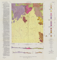
Geology of the Oak Spring Quadrangle, Nye County, Nevada, 1963

Date

1963

Description

58 x 46, on sheet 88 x 84 cm., fold. in envelope 30 x 24 cm. Relief shown by contours and spot heights. "Contour interval 20 feet." "Prepared in cooperation with the U.S. Atomic Energy Commission." Title on envelope: Geologic map of the Oak Spring Quadrangle, Nye County, Nevada. Includes 3 col. cross sections, text, and quadrangle location map. Original publisher: Interior, Geological Survey, Series: Geologic quadrangle map GQ, Scale: 1:24 000.

Image

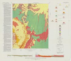
Geologic map of the Ammonia Tanks quadrangle, Nye County, Nevada, 1967

Date

1967

Description

58 x 46 cm., on sheet 84 x 100 cm., folded in envelope 30 x 24 cm. Relief shown by contours and spot heights. "Base by U.S. Geological Survey, 1961." "Geology mapped in 1961-65." "Contour interval 20 feet." Includes 3 col. cross sections, 1 index map, text with bibliography, and quadrangle location map. "Prepared in cooperation with the U. S. Atomic Commission." Original publisher: Interior, Geological Survey, Series: Geologic quadrangle map GQ, Scale: 1:24 000.

Image

Geologic map of the Trail Ridge quadrangle, Nye County, Nevada, 1968

Date

1968

Description

58 x 46 cm., on sheet 79 x 91 cm., folded in envelope 30 x 24 cm. Relief shown by contours and spot heights. "Prepared in cooperation with the U.S. Atomic Energy Commission." "Base by U.S. Geological Survey, 1962." "Geology mapped in 1963." "Contour interval 20 feet." Includes text, 2 col. cross sections, quadrangle location map, and 1 index map. Original publisher: Interior, Geological Survey, Series: Geologic quadrangle map GQ, Scale: 1:24 000.

Image

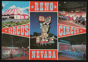
Collage of Circus Circus in Reno, Nevada: postcard

Date

1940 (year approximate) to 1990 (year approximate)

Description

From the Harvey's Hotel and Casino Postcard Collection (PH-00367) -- A collage of the interior and exteror of the Circus Circus Hotel and Casino in Reno Nevada. Inscription with the image says, "Circus Circus Hotel-Casino 'Topsy' the world's largest clown - 130 feet tall and weighing 90 thousand pounds - welcomes all to this new hotel and casino complex in the heart of Reno. A Midway with 'fun for all ages' and live circus acts under the Big Top complete this family-oriented Hotel and Casino complex."

Image