Search Results
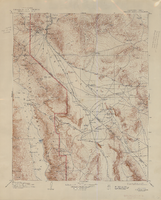
Topographic map of the Furnace Creek quadrangle, Nevada and California, 1947
Date
1947
Description
'E.M. Douglas, geographer. R.H. Chapman, in charge of section. Topography by R.H. Chapman, B.D. Stewart, J.E. Blackburn and D.F.C. Moor. Traingulation by R.H. Chapman and D.F.C. Moor. Surveyed in1905-1906.' 'Edition of Apr. 1910, reprinted 1947.' Scale 1:250,000 ; polyconic proj. (W 117°00´--W 116°00´/N 37°00´--N 36°00´). Relief shown by contours and spot heights. 'North American datum.' 'Contour interval 100 feet.' 'Datum is mean sea level.' Text and illustrations from the Topographic maps of the United States series on verso. Series: The topograhic maps of the United States. United States, Dept. of the Interior, Geological Survey
Text
Red Rock Canyon National Conservation Area Records
Identifier
MS-00399
Abstract
The Red Rock Canyon National Conservation records (1965-2007) contain information about the Red Rock Canyon National Conservation Area (previously the Red Rock Canyon Recreation Lands). It largely consists of newspaper clippings on a variety of events related to Red Rock Canyon from 1965 to 1998 with the bulk from the 1980s and 1990s. The records also include Bureau of Land Management documents pertaining to interpretive efforts, visitation statistics, and law enforcement reports. Also included are the newsletters (1990-1998) and volunteer training manual of the Friends of Red Rock Canyon, a non-profit volunteer organization.
Archival Collection

Geologic map of the Topopah Spring quadrangle, Nye County, Nevada, 1970
Date
1970
Description
58 x 46 cm., on sheet 84 x 88 cm., folded in envelope 30 x 24 cm. Relief shown by contours and spot heights. "Geology mapped in 1962-63." Includes description of map units, colored columnar section, 3 colored cross sections, and quadrangle location map. "Prepared in cooperation with the U. S. Atomic Commission." Original publisher: Interior, Geological Survey, Series: Geologic quadrangle map GQ, Scale: 1:24 000.
Image