Search Results
Las Vegas and Tonopah Railroad Blueprints
Identifier
Abstract
The Las Vegas and Tonopah Railroad Blueprints consists of twenty-four of the original thirty blueprints as part of the Interstate Commerce Commission (I.C.C.) Valuation Index Section I. They are labeled "Right-of-Way & Track Map, Las Vegas & Tonopah Railroad" and dated June 30, 1915. The blueprints contain four miles of railroad lines per sheet with a scale of 6 3/4 inches per mile. The collection also includes one sheet from the Bullfrog Goldfield Railroad company, which used the track, yard, and facilities of the Las Vegas and Tonopah and Railroad company between Beatty and Goldfield, Nevada.
Archival Collection
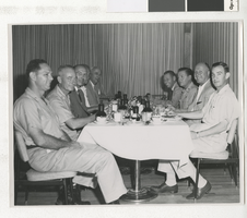
Photograph of business executives and Air Force officers, Las Vegas (Nev.), circa 1960
Date
Archival Collection
Description
Image

Allison Henderson oral history interview, 2013 March 13
Level of Description
Scope and Contents
Henderson became an EMT in 1991 while working at a medical clinic in Beatty, Nevada.
Archival Collection
Collection Name: History of Emergency Medical Services in Nevada Oral History Interviews
Box/Folder: Digital File 00
Archival Component
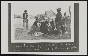
Native Americans along a trail: photographic print
Date
Archival Collection
Description
Image
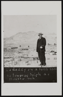
Lorraine Perry's father: photographic print
Date
Archival Collection
Description
Image
Nevada Mining Photograph Collection
Identifier
Abstract
The Nevada Mining Photograph Collection depicts mining activities, miners, and mining towns in Nevada from 1868 to 1937. The photographs primarily depict the towns of Tonopah, Nevada and Goldfield, Nevada, including mills, buildings, mine shafts, and panoramic views of the landscape. The photographs also depict Beatty, Lost City, Delamar, Candelaria, Winnemucca, Virginia City, Rhyolite, Elko, and Reno, Nevada. The photographs also include portraits of early settlers in Nevada, Native Americans, children, parades, celebrations, and funerals.
Archival Collection