Search Results
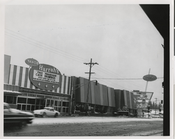
Photograph of Harrah's Tahoe side entrance (Stateline, Nev.), circa mid 1960s
Date
Archival Collection
Description
Side entrance of Harrah's Tahoe.
Site Name: Harrah's Tahoe
Address: 15 Highway 50
Image
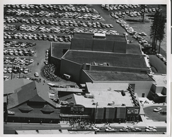
Aerial photograph of Harrah's Tahoe (Stateline, Nev.), circa 1959
Date
Archival Collection
Description
Aerial view of Harrah's Tahoe.
Site Name: Harrah's Tahoe
Address: 15 Highway 50
Image

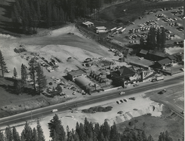
Photograph of Harrah's Tahoe construction site sign (Stateline, Nev.), circa 1972
Date
Archival Collection
Description
Sign at the Harrah's Lake Tahoe construction site.
Site Name: Harrah's Tahoe
Address: 15 Highway 50
Image
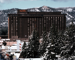
Photograph of Harrah's Tahoe tower from the south (Stateline, Nev.), after 1973
Date
Archival Collection
Description
Southern view of the Harrah's Lake Tahoe tower.
Site Name: Harrah's Tahoe
Address: 15 Highway 50
Image
Aerial photograph of Tahoe Plaza (Stateline, Nev.), circa 1955
Date
Archival Collection
Description
Tahoe Plaza from the air before it was incorporated into Harrah's Tahoe.
Site Name: Harrah's Tahoe
Address: 15 Highway 50
Image
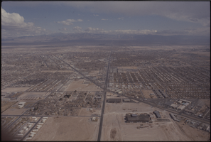
Glass slides of aerial views, buildings, and construction sites, Las Vegas (Nev.), 1950s-1960s (tray 2 of 3)
Date
Archival Collection
Description
Slides collected by the Culinary Workers Union Local 226 depict Las Vegas during the 1950s and the 1960s. Individual photos show aerial views of the city, construction sites, residential streets, and buildings such as union offices, shopping centers, banks, schools, houses of worship, etc. Other important sites depicted include McCarran Airport, the Las Vegas Convention Center, and the University of Nevada, Las Vegas. A number of slides are illustrated graphs charting growth in the city between 1954 and 1964. Tray 2 of 3. The original slides were retained by the Union.Arrangement note: Series V. Glass slides
Image
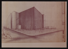
Silver State Disposal building: conceptual drawing
Date
Archival Collection
Description
Image
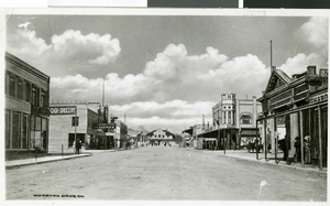
Postcard of Fremont Street, Las Vegas, circa early 1900s
Date
Archival Collection
Description
Image
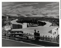
Photograph of a model of the proposed Hotel Frontier, circa 1964
Date
Archival Collection
Description
Model of the proposed Hotel Frontier
Site Name: Frontier
Address: 3120 Las Vegas Boulevard South
Image
Transcript of interview with Kate Hausbeck Korgan by Claytee White, February 3, 2010
Date
Archival Collection
Description
Kate Hausbeck Korgan was raised and educated in Buffalo, New York. In 1995, after receiving her doctorate in sociology from University of Buffalo, her job search brought her to the University of Nevada, Las Vegas. It was a great fit and she tells of falling in love with the school, the city, and the John S Park Neighborhood. Kate retells the story of the house where she and her family reside. It's original owners were the Gambles who built the house in 1936. It was the second house built in the neighborhood and is the only inhabited adobe house in the city. The house is located on the fringe of John S. Park Neighborhood, about a block off the Strip. Though the location creates traffic that she doesn't like, it is not enough to cause her to move. She describes the newer generation of residents and the changes as the number of school aged children increased. Kate's perspective includes what she describes as the ebb and flow of the community, the beginning of First Fridays, the
Text