Search Results
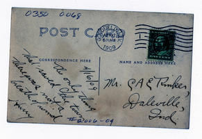
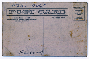
Fire in Goldfield, Nevada: postcard
Description
Fire in Goldfield, Nevada, night of April 15th '09. There is a handwritten message on back. Photographer credit: Bertram.
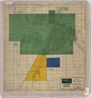
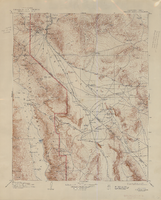
Map of Las Vegas and vicinity, Clark County, Nevada, April 15, 1951
Date
1951-04-15
Description
'2nd issue. 4/15/51.' 'Jack Asher, Reg. C.E. & Land Surveyor, Nev. #305.' Cadastral map..
Image
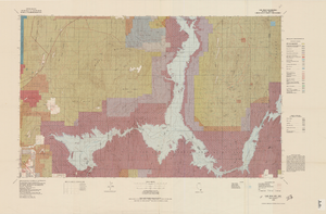
Topographic map of Lake Mead quadrangle, Nevada and Arizona, 1979
Date
1979
Description
'Edited and published by the Bureau of Land Management. Base map prepared by the U.S. Geological Survey.' 'Surface management status by BLM, 1981.Minerals management status by BLM, 1981.' Relief shown by contours and spot heights. Contour interval 50 meters. Compiled from USGS maps dated 1952-1970. Revised from aerial photographs taken 1972-73. Map edited 1979. Includes location map and index to 1:24,000 and 1:62,500-scale maps. Shows minerals owned by the federal government. 'N3600--W11400/30x60.' 'SE/4 Las Vegas (NJ 11-12) 1:250,000-scale map.' Scale 1:100,000universal transverse Mercator proj. (W 115°00'--W 114°00'/N 36°30'--N 36°00'). Series: Surface-minerals management status. United States. Bureau of Land Management. Surface-minerals management status. Filing title: Lake Mead, Nev.--Ariz., 1979. Shows township and range lines. Published by United States, Dept. of the Interior, Bureau of Land ManagementDenver, Colo. : For sale by U.S. Geological Survey,
Image
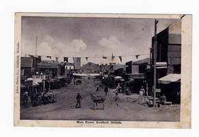
Main Street, Goldfield, Nevada, postcard
Description
Postcard of Main Street, Goldfield, Nevada.
Main Street, Goldfield, Nevada, postcard
Description
Postcard of Main Street, Goldfield, Nevada.
Topographic map of the Furnace Creek quadrangle, Nevada and California, 1947
Date
1947
Description
'E.M. Douglas, geographer. R.H. Chapman, in charge of section. Topography by R.H. Chapman, B.D. Stewart, J.E. Blackburn and D.F.C. Moor. Traingulation by R.H. Chapman and D.F.C. Moor. Surveyed in1905-1906.' 'Edition of Apr. 1910, reprinted 1947.' Scale 1:250,000 ; polyconic proj. (W 117°00´--W 116°00´/N 37°00´--N 36°00´). Relief shown by contours and spot heights. 'North American datum.' 'Contour interval 100 feet.' 'Datum is mean sea level.' Text and illustrations from the Topographic maps of the United States series on verso. Series: The topograhic maps of the United States. United States, Dept. of the Interior, Geological Survey
Text
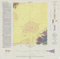
Geologic map of the Frenchman Flat quadrangle, Nye, Lincoln, and Clark Counties, Nevada, 1965
Date
1965
Description
58 x 47 cm., on sheet 81 x 81 cm., folded in envelope 30 x 24 cm. Relief shown by contours and spot heights. "Geology mapped in 1962. Contours on pre-Cenozoic rocks by D. L. Healey and C. H. Miller, 1958-63." Includes text, col. cross section and quadrangle location map. "Prepared in cooperation with the U.S. Atomic Energy Commission." Original publisher: Interior, Geological Survey, Series: Geologic quadrangle map GQ, Scale: 1:24 000.
Image
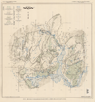
Generalized hydrogeologic map of lower Moapa-Lake Mead area, Clark County, Nevada, 1968
Date
1968
Description
'Hydrogeology by F.E. Rush, 1968. Geology adapted from Longwell and others 1965.' In lower left corner: ' Base: U.S. Geological Survey 1:250,000 topographic series; Las Vegas (1954).' At top of map: 'United States Department of the Interior, Geological Survey. Department of Conservation and Natural Resources, State of Nevada.' Relief shown by contoursIncludes township and range lines. Scale 1:250,000 (W 115°00´--W 114°15´/N 36°30´--N 36°15´). Series: Water resources-reconnaissance series report . Originally published as plate 1 in Water-resources appraisal of the lower Moapa-Lake Mead area, Clark County, Nevada / by F. Eugene Rush, published by State of Nevada Dept. of Conservation and Natural Resources in 1968 in volume 50 of the serial Water resources-reconnaissance series report.
Image
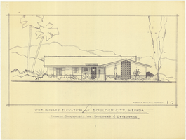
Architectural drawing of residential home in Boulder City, Nevada, preliminary elevation, 1962
Date
1962
Archival Collection
Description
Preliminary drawing of front exterior elevation of ranch-style residential home in Boulder City, Nevada.
Architecture Period: Mid-Century ModernistImage
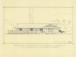
Architectural drawing of residential home in Boulder City, Nevada, preliminary elevation, 1962
Date
1962
Archival Collection
Description
Preliminary drawing of front exterior elevation of a ranch-style residential home in Boulder City, Nevada.
Architecture Period: Mid-Century ModernistImage