
Search the Special Collections and Archives Portal

Search Results

Display    Results Per Page
Displaying results 181 - 190 of 576607

Map showing profile of 24-inch cast iron water pipeline for Las Vegas, Nevada, May 20, 1930

Date

1930-05-20

Description

'As constructed. Drawing W.O. - 8577. Office of Chief Engineer, Los Angeles. Drawing No. 41092.' 'Scale for details 1"=10'. 5-20-1930. P.F.D.' 'Scale 1"=100'.' 'Profile of new 24" CI pipe. Scale 1"=600'. Ver. 1"=20'.' Blueprint. Map of the water pipes for Las Vegas. Includes the buildings in the railroad yard, a detailed map of a section of the pipe, a profile of the 24 inch C.I. pipe, and a map of the point of diversion. Date of detailed map is 5-20-1930. Library's copy has hand-written additions in color. Los Angeles & Salt Lake Railroad Co., Office of Chief Engineer,

Image

Map of Lincoln County, Nevada and Mohave County, Arizona area, 1892

Date

1892

Description

'Henry Gannett, chief geographer ; A.H. Thompson, geographer in charge ; triangulation by H.M. Wilson ; topography by H.M. Wilson and Powell survey.' 'Edition of Mar. 1892, reprinted 1929.' Handwritten legend on right-side margin of map. Original publisher: Dept. of the Interior, U.S. Geological Survey. Scale 1:250,000
polyconic proj. (W 115°--W 114°/N 37°--N 35°).

Image

Map showing configuration of potentiometric surfaces in Paleozoic and Cenozoic aquifers in the area between the Las Vegas Valley and the Amargosa Desert, Nevada, 1963

Date

1963

Description

'Department of the Interior, United States Geological Survey. TEI-840.' 'Prepared in cooperation with the U.S. Atomic Energy Commission.' 'Contours in northwest Las Vegas Valley from Malmberg, 1961.' Relief shown by contours. Shows township and range lines. Scale [ca. 1:253,440. 1 in.=aprrox. 4 miles] (W 114°00´--W 115°00´--N 37°00´/N 36°00´). Originally published in A summary of the ground-water hydrology of the area between the Las Vegas Valley and the Amargosa Desert, Nevada : with special reference to the effects of possible new withdrawals of ground water / by Isaac J. Winograd, published by the U.S. Geological Survey in 1963 as number 840 of the Trace elements investigations report.

Image

Map showing proposed new 12" well and pipe line changes at Water Springs, Las Vegas, Nevada, circa 1920

Date

1916 to 1925

Description

In lower right corner: '6-W-74.' Scale: 1" = 500'.

Image

Charles S. Sprague and Benjamin Gill Papers on Nevada Mining

Identifier

MS-00570

Abstract

The Charles S. Sprague and Benjamin Gill Papers on Nevada Mining (1904-1925) are comprised of various records from the mining companies owned and operated by businessmen Charles S. Sprague and Benjamin Gill who were active in the central Nevada boomtowns of Goldfield and Tonopah in the early twentieth century. Documents include correspondence, receipts and invoices, detailed records and copies of government legislative bills relating to the mining industry, and other business correspondence. Sprague's collection consists of his mining business correspondence dating from 1906 to 1925. Gill's papers are comprised of his business correspondence from 1916 to 1922.

Archival Collection

Map showing U.S. Bureau of Reclamation Region 3 projects in Arizona, California, Nevada, New Mexico and Utah, September 1967

Date

1967-09

Description

'United States, Department of the Interior, Stewart L. Udall, Secretary. Bureau of Reclamation, Floyd E. Dominy, Commissioner.' 'Map. No. X-300-738. September 1967.' Scale [ca. 1:1,774,080] (W 119°--W 108°/N 39°--N 32°). Relief shown pictorially. Shows completed, under construction and proposed dams and reservoirs, canals, and aqueducts, power plants, pumping plants, substations, transmission lines, tunnels and siphons. Also shows non-Bureau of Reclamation dams, reservoirs, tunnels, pipelines and irrigated lands. Includes inset map of location of Region 3 and key map of drainage basins. Bureau of Reclamation, [Region 3?].

Image

Blueprint map showing proposed new 12" well and pipe line changes at water springs, Las Vegas, Nevada, circa 1920

Date

1916 to 1925

Description

Stamped : 'Approved (Signed) A. Maguire, Assistant Chief Engineer.' In lower right corner: '6-W-74.' Some annotations written over in yellow; black dotted line added between forebay and final spring in the northwest. Scale [ca. 1:6,000] 1 in.=500 feet

Image

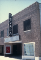
Slide of the Nevada Theater, Wells, Nevada, 1986

Date

1986

Description

An image of the Nevada Theater located in Wells. The black and white neon sign located above the entrance doors to the building reads: "Nevada." Site Name: Nevada Theater (Wells, Nev.)

Image

Aid for AIDS of Nevada fan

Date

1990 (year approximate) to 1999 (year approximate)

Description

From the Dennis McBride Collection on LGBTQ Las Vegas, Nevada (MS-00802) -- Alphabetical research files -- AIDS: Organizations: Aid for AIDS of Nevada (AFAN) file.

Text

Hotel Nevada billboard, Ely, Nevada

Date

2016 (year approximate) to 2020 (year approximate)

Description

View of the Hotel Nevada billboard reading "Hotel Nevada Western Hospitality."

501 E Aultman St, Ely, NV 89301


Image