Search Results

Map of Lincoln County, Nevada and Mohave County, Arizona area, 1892
Date
Description
polyconic proj. (W 115°--W 114°/N 37°--N 35°).
Image
Jewish Nevada Records
Identifier
Abstract
The Jewish Nevada Records document the organization's philanthropic activities in Las Vegas, Nevada from 1978 to 2018. The majority of the collection represents the organization's activities under the name the Jewish Federation of Las Vegas. The collection includes administrative files, annual reports, marketing materials, donation records, video recordings of interviews and events, and audio recordings of board meetings. The collection also includes photographic prints and negatives of events hosted by Jewish Nevada.
Archival Collection

Map showing configuration of potentiometric surfaces in Paleozoic and Cenozoic aquifers in the area between the Las Vegas Valley and the Amargosa Desert, Nevada, 1963
Date
Description
Image

Map showing proposed new 12" well and pipe line changes at Water Springs, Las Vegas, Nevada, circa 1920
Date
Archival Collection
Description
Image
Charles S. Sprague and Benjamin Gill Papers on Nevada Mining
Identifier
Abstract
The Charles S. Sprague and Benjamin Gill Papers on Nevada Mining (1904-1925) are comprised of various records from the mining companies owned and operated by businessmen Charles S. Sprague and Benjamin Gill who were active in the central Nevada boomtowns of Goldfield and Tonopah in the early twentieth century. Documents include correspondence, receipts and invoices, detailed records and copies of government legislative bills relating to the mining industry, and other business correspondence. Sprague's collection consists of his mining business correspondence dating from 1906 to 1925. Gill's papers are comprised of his business correspondence from 1916 to 1922.
Archival Collection

Map showing U.S. Bureau of Reclamation Region 3 projects in Arizona, California, Nevada, New Mexico and Utah, September 1967
Date
Description
Image

Blueprint map showing proposed new 12" well and pipe line changes at water springs, Las Vegas, Nevada, circa 1920
Date
Archival Collection
Description
Image
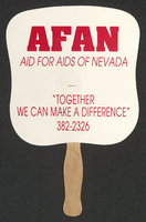
Aid for AIDS of Nevada fan
Date
Archival Collection
Description
Text
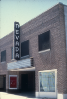
Slide of the Nevada Theater, Wells, Nevada, 1986
Date
Archival Collection
Description
Image
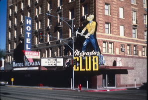
Slide of Nevada Club, Ely, Nevada, 1986
Date
Archival Collection
Description
Image