Search Results
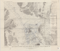
Map of part of Las Vegas Valley, Nevada, showing the piezometric surface in February 1955
Date
Description
Relief shown by contours. Includes township and range lines. Scale 1:96,000 (W 115°30´--W 114°45´/N 36°30´--N 36°00´). Series: Water-supply paper (Washington, D.C.)
1780. Originally published as plate 3 of Available water supply of the Las Vegas ground-water basin, Nevada, by Glenn T. Malmberg, published by the Geological Survey in 1965 as its Water-supply paper 1780.
Image
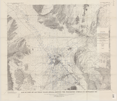
Map of part of Las Vegas Valley, Nevada, showing the piezometric surface in September 1955
Date
Description
Relief shown by contours. Includes township and range lines. Scale 1:96,000 (W 115°30´--W 114°45´/N 36°30´--N 36°00´). Series: Water-supply paper (Washington, D.C.)
1780. Originally published as plate 4 of Available water supply of the Las Vegas ground-water basin, Nevada, by Glenn T. Malmberg, published by the Geological Survey in 1965 as its Water-supply paper 1780.
Image
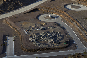
Water truck at Ascaya development, Henderson, Nevada: digital photograph
Date
Archival Collection
Description
Image
Nevada-related trade magazines and publications: includes Las Vegas City Magazine, Las Vegas Israelite, Sagebrush, Forester, New American, Public Gaming, Casino Gaming, Elks Magazine, KNPR (Nevada Public Radio) newsletter, Nevada Historical Society Newsletter, Mobile Home News, Nevada Mining, and Nevada Builders’ Association, as well as other magazines and newspapers on topics such as education, Nevada business, and agriculture, 1986
Level of Description
Archival Collection
Collection Name: John Vergiels Political Papers
Box/Folder: Box 010 (Restrictions apply), Box 011 (Restrictions apply), Box 012 (Restrictions apply)
Archival Component
Royal Nevada Hotel, approximately 1950-1959
Level of Description
Archival Collection
Collection Name: Neon in Nevada Photograph Collection
Box/Folder: Binder PB-005
Archival Component
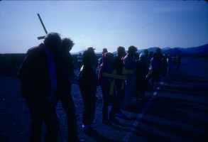
Slide of protesters with crosses demonstrating near the Nevada Test Site, April 1986
Date
Archival Collection
Description
Image
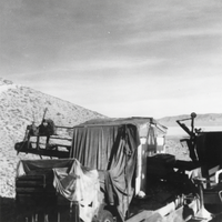
Wilson's placer plant in Ophir Canyon, Nevada: photographic print
Date
Archival Collection
Description
From the Nye County, Nevada Photograph Collection (PH-00221) -- Series VII. Other areas in Nye County -- Subseries VII.I. Wilson Family (Toiyabe Mountains, Nevada). The canvas covered structure was a darkened area for sorting scheelite with a black light during daylight hours.
Image
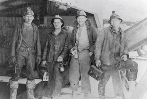
Drilling crews at the New Gold Mine, Nevada: photographic print
Date
Archival Collection
Description
From the Nye County, Nevada Photograph Collection (PH-00221) -- Series V. Smoky Valley, Nevada and Round Mountain, Nevada -- Subseries V.C. Lofthouse-Berg Families (Round Mountain). Written on the back of the image: “With some of my drilling crews, I’m second from the right at the collar of the New Gold Mine, the Porphyry Gold Mine shaft in 1936-37.” Individuals are unidentified except for the man second from the right, who may be Steve Dittman.
Image

Slide of the Primadonna Club sign, Reno, Nevada, circa 1970s
Date
Archival Collection
Description
Image
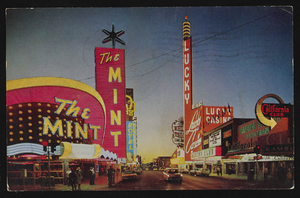
Fremont Street in Las Vegas, Nevada: postcard
Date
Archival Collection
Description
Image