
Search the Special Collections and Archives Portal

Search Results

Display    Results Per Page
Displaying results 5301 - 5310 of 12603

Carolyn Whaley oral history interview

Identifier

OH-01959

Abstract

Oral history interview with Carolyn Whaley conducted in 2005 by an unknown interviewer for the UNLV University Libraries Oral History Collection. Whaley discusses her early interest in music and her successful audition for the United States Air Force Women's Air Force (WAF) Band in 1959. She explains that the band was the only all-female band in the military between 1951 and 1961, and shared a number of stories about the function and activities of the band. Later, she discusses her civilian career as a music teacher in Barstow, California and decision to move to Las Vegas, Nevada after her retirement in 2000. She also remarks on the lack of interest that officials at Nellis Air Force Base in Las Vegas showed in veterans.

Archival Collection

Tunica County

No description.

Geographic Location

Leflore County

No description.

Geographic Location

Cleveland

No description.

Geographic Location

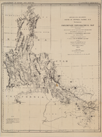
Map of explorations and surveys south of the Central Pacific Railroad made by the U.S. Army Corps of Topographical Engineers, 1871

Date

1871

Description

'Preliminary topographical map embracing in skeleton a portion only of the notes from surveys made in accordance with Par.II Special Orders No. 109 War Dept., March 18th, 1871 and letter of instructions of Brig. General A.A. Humphreys, Chief of Eng'rs. dated March 23rd, 1871. Conducted under the immediate direction of 1st Lieutenant Geo. M. Wheeler, Corps of Eng'rs., assisted by 1st Lieutenant D.W. Lockwood, Corps of Eng'rs. and 2nd Lieutentant D.A. Lyle, 2nd U.S. Artillery, during the summer and fall of 1871. Louis Nell, chief topographer and draughtsman.'' At head of map: 'Explorations in Nevada and Arizona. U.S. Engineer Department.' In lower left corner: 'Note: This map is a hasty and partial compilation from the topographical data already received, many still remaining en route. Upon it is projected in skeleton the groundwork of the area examined. All points except the prominent astronomical positiions are subject to lsight modification upon the final map.' Shows area through central Nevada, eastern California, and central Arizona. Relief shown by hachures. Published by the War Dept. Scale [ca. 1:1,520,640]. 1 in. to 24 miles (W 118°--W 109°/N 41°--N 32°).

Image

Visual material, 1914-1988

Level of Description

Series

Scope and Contents

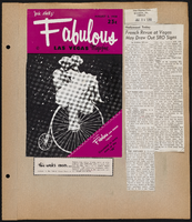
The YESCO visual materials series (1914-1988) document a visual history of YESCO from its early beginnings, through its expansions, to its work in the 1980s. They include visuals of various YESCO plants, shops, buildings, equipment and personnel, as well as various signs created and installed by YESCO in multiple states. The series includes black-and-white and color photographs as well as Polaroids. It contains photographs, slides, negatives, and digital files of a variety of Las Vegas landmarks and hotels and casinos, including The Mint, Flamingo, Sahara, Caesar’s Palace, Fremont Street, Vegas Vic, Whiskey Pete’s, the University of Nevada, Las Vegas Silver Bowl Stadium, and Excalibur. The series also contains photographs of signs YESCO created for various banks, theaters, cafes, gas stations, and other businesses, both large and small, around the western United States. Digital files appear to be copies of select materials throughout this series.

Archival Collection

Young Electric Sign Company (YESCO) Corporate Records
To request this item in person:
Collection Number: MS-00403
Collection Name: Young Electric Sign Company (YESCO) Corporate Records
Box/Folder: N/A

Archival Component