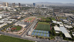
Search Results

Topographic map of the northeast quadrangle of the metropolitan Las Vegas, Nevada area, 1967
Date
1967
Description
Scale 1:24,000 ; polyconic proj. (W 115°730--W 115°0000/N 36°1500--N 36°730) ; 1 map : col. ; 58 x 47 cm ; 7.5 minute series (topographic) ; Relief shown by contours and spot heights ; Filing title: Las Vegas NE, Nev ; "AMS 2956 II NE--Series V896." ; Contour interval 20 feet ; "Topography by photogrammetric methods from aerial photographs taken 1965. Field checked 1967." ;Includes quadrangle location map ; Interior--Geological Survey
Image

Topographic map of the northwest quadrangle of the metropolitan Las Vegas, Nevada area, 1967
Date
1967
Description
Scale 1:24,000 ; polyconic proj. (W 115°1500--W 115°730/N 36°1500--N 36°730) ; 1 map : col. ; 58 x 47 cm ; 7.5 minute series (topographic) ; Relief shown by contours and spot heights ; Filing title: Las Vegas NW, Nev ; "AMS 2956 II NW--Series V896." ; Contour interval 10 feet ; "Topography by photogrammetric methods from aerial photographs taken 1965. Field checked 1967." ; Includes quadrangle location map ; Interior--Geological Survey
Image

Topographic map of the southeast quadrangle of the metropolitan Las Vegas, Nevada area, 1967
Date
1967
Description
Scale 1:24,000 ; polyconic proj. (W 115°0730--W 115°0000/N 36°0730--N 36°0000) ; 1 map : col. ; 58 x 47 cm ; 7.5 minute series (topographic) ; Relief shown by contours and spot heights ; Filing title: Las Vegas SE, Nev ; "AMS 2956 II SE--Series V896." ; Contour interval 20 feet ; "Topography by photogrammetric methods from aerial photographs taken 1965. Field checked 1967." ; Includes quadrangle location map ; Interior--Geological Survey
Image

Topographic map of the southwestern quadrangle of the metropolitan Las Vegas, Nevada area, 1967
Date
1967
Description
Scale 1:24,000 ; polyconic proj. (W 115°1500--W 115°0730/N 36°0730--N 36°0000) ; 1 map : col. ; 58 x 47 cm ; 7.5 minute series (topographic) ; Relief shown by contours and spot heights ; Filing title: Las Vegas SW, Nev ; "AMS 2956 II SW--Series V896." ; Contour interval 10 feet ; "Topography by photogrammetric methods from aerial photographs taken 1965. Field checked 1967." ; Includes quadrangle location map ; Interior--Geological Survey
Image
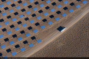
Heliostats (mirrors) at Crescent Dunes Solar, near Tonopah, Nevada: digital photograph
Date
2014-06-26
Archival Collection
Description
Photographer's note: "10,347 heliostats (mirrors) are part of the Crescent Dunes Solar project. Each heliostat is 34 feet tall, uses 35 mirrors, and has a surface area of 1258 square feet, or 115.7 square meters. On site photo, Crescent Dunes Solar, near Tonopah, Nevada, USA."
Photographer's assigned keywords: "110 megawatts; CSP; Concentrated Solar Energy; Concentrated Solar Power; Crescent Dunes; NV; Nevada; Solar Reserve; SolarReserve; Tonopah; aerial; concentrated solar thermal; green energy; heliostats; mirrors; molten salt; renewable energy; storage."
Photographer's assigned keywords: "110 megawatts; CSP; Concentrated Solar Energy; Concentrated Solar Power; Crescent Dunes; NV; Nevada; Solar Reserve; SolarReserve; Tonopah; aerial; concentrated solar thermal; green energy; heliostats; mirrors; molten salt; renewable energy; storage."
Image
The Wheel Las Vegas Rotary Club newsletter, November 23, 1966
Date
1966-11-23
Archival Collection
Description
Newsletter issued by the Las Vegas Rotary Club
Text
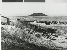
Panoramic photograph of Blair (Nev.), circa 1907
Date
1906 to 1908
Archival Collection
Description
There was an inscription on the image. "Blair was located three miles north of Silver Peak and was founded in 1906 by the Pittsburgh Silver Peak Gold Mining Company whose 120 stamp mill (under construction in the foreground) overlooked the town. Ore from the Mary Tunnel reached the mill via a 14,000 foot aerial tramway. The town's population was 700 and Blair was served by the mining company's Silver Peak Railroad. Blair prospered until 1917 when the mine and mill were closed. The mill processed over $6,000,000 worth of gold ore.
Image