Search Results
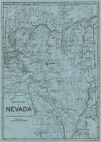
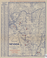
Sketch map of Nevada and the southeastern portion of California, 1906
Date
1906
Description
34 x 24 cm. Relief shown by hachures. Map may be a reprint of a map by George S. Clason, published by the Clason Map Co. in Denver, Colo., in 1906. Map is printed on blue paper. "OPHIR" and a star printed near Pueblo in Nye County. Shows railroad routes.
Image
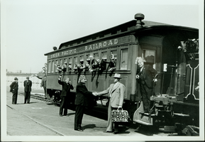
Group of unidentified people at a Union Pacific Railroad at unknown location: photographic print
Date
1880 to 1979
Archival Collection
Description
Dorothy Bell Scans UNLV-Public Lands Institute
Image

Map of Las Vegas Rancho, Lincoln County, Nevada, September 15, 1904
Date
1904-09-15
Description
'Being part of Township 20 S. R.61 E. MT. D. B.&.M, containing 1864.49 acres. Division engineer's office at the front, AMB, September 15th, 1904. A.L. Jones, Division Engineer. Surveyed by W.G. Watson, Assistant Engineer. Dwg. 30296.' Includes traverse table. Shows land owned by the San Pedro, Los Angeles & Salt Lake Railroad, its right of way and the right of way for the Las Vegas & Tonopah Railroad, land owned by the Las Vegas Land & Water Company including Clark's Las Vegas Townsite with the Bucks Addition and the Wardie Addition, and parcels sold from the Las Vegas Land & Water Company land. Scale: [1:9,600]. 1 in. to 800 feet. Library's copies 1 and 4 have land owned by the San Pedro, Los Angeles & Salt Lake Railroad hand-colored in pink and the rest of the Las Vegas Rancho not owned by the Las Vegas Land & Water Company hand-colored in green. Library's copy 2 has buildings of the Stewart Ranch drawn in and labeled in pencil. Library's copy 3 has addition and subtraction problems in pencil on the verso. Library's copy 4 has "Original purchase--1864.49 acres R.R.C. + L.V.L. + W. Co.--In colors." written in pencil on the verso followed by "(1904)" in red pencil. Library's copy 4 also has label on verson made of brown paper with "No 5 Las Vegas Ranch being part township ( 1904)" typed on it.
Image
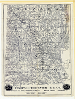
Map showing Tonopah & Tidewater Railroad Company line from Ludlow, California to Goldfield, Nevada, circa 1907
Date
1905 to 1909
Description
Scale not given. Relief shown by hachures and spot heights. Shows township and range grid. Shows mines, camps and ranches. Tonopah & Tidewater Railroad Company. Library's copy mounted on linen.
Image
Sketch map of Nevada and the southeastern portion of California, 1906
Date
1906
Description
1907 written in red pencil at top of map. 41 x 29 cm. Relief shown by hachures. Copyright held by George S. Clason. Includes index. "Compliments of A.E. Holt, real estate and mines, Bullfrog Mining Dist., Rhyolite, Nevada." Red star indicates location of A.E. Holt company. Shows railroad routes. Library's copy has "1907" printed with brown crayon in upper margin and has four sets of two holes punched in a vertical line along the right third of the map. Original publisher: Clason Map Co..
Image
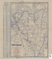
Sketch map of Nevada and the southeastern portion of California, 1906
Date
1906
Description
42 x 29 cm. Relief shown by hachures. Copyright held by George S. Clason. "Compliments of the Patrick Investment Co. ... Denver, Colorado." Includes index. Shows railroad routes. "We have offices, representatives and properties in every camp marked in red on this map." Original publisher: Clason Map Co..
Image
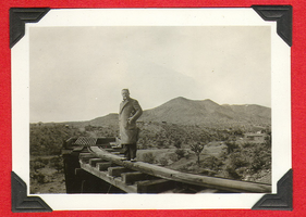
Unidentified man standing on railroad tracks: photographic print
Date
1880 to 1979
Archival Collection
Description
Bell Family Scrapbook scanning, Set 4, proofed 11.04.2010 Unidentified man standing on railroad tracks in the Mojave Desert. Several unidentified buildings are in the distance
Image

Map showing location of the Las Vegas & Tonopah Railroad from Las Vegas to Bullfrog, Nevada, 1906
Date
1906
Archival Collection
Description
'Office of Chief Engineer' printed on map above date.
Image
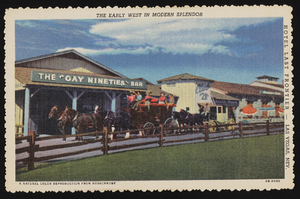
Last Frontier Village at the Last Frontier Hotel: postcards
Date
1940 (year approximate) to 1949 (year approximate)
Archival Collection
Description
Postcards of the Last Frontier Village at the Last Frontier Hotel in Las Vegas. (c. 1940s)
Image
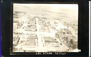
Aerial photograph of Las Vegas, westward direction, circa 1920
Date
1920 to 1925
Archival Collection
Description
Aerial view of Las Vegas
Image