Search the Special Collections and Archives Portal
Search Results
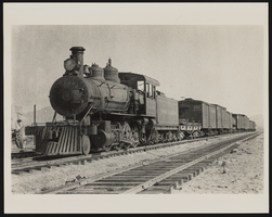
Midway Ore Station at Tonopah and Tidewater: photograph
Date
1907
Archival Collection
Description
Tonopah & Tidewater, Midway Ore Station, 1907. The railroad ran from E California to SW Nevada. Inscription reads "Meeting final 20 mule team wagons." The stamp on the back of the photo says: "Mallory Hope Ferrell P. O. Box 2837 Peachtree City, GA 30269."
Image
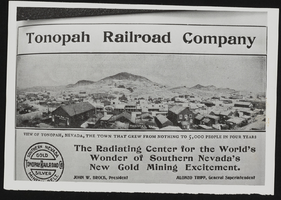
Newspaper clipping of advertisement for the Tonopah Railroad Company: photographic print
Date
1905 (year approximate)
Archival Collection
Description
Advertisement for Tonopah Railroad Company in the Tonopah newspaper, circa 1905.
Image
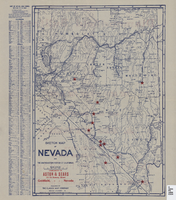
Sketch map of Nevada and the southeastern portion of California, 1906
Date
1906
Description
41 x 29 cm. Relief shown by hachures. Copyright held by George S. Clason. Includes index. "Compliments of Aston & Sears ... Goldfield, Nevada." Red stars probably indicate location of towns with either offices of or claims owned by Aston & Sears. Shows railroad routes. Ad for shares in the Diamond Bullfrog claim on verso. Original publisher: Clason Map Co..
Image
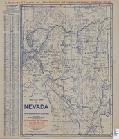
Sketch map of Nevada and the southeastern portion of California, 1906
Date
1906
Description
42 x 30 cm., fold. to 23 x 11 cm. Relief shown by hachures. Copyright: George S. Clason. "Compliments of D. Mackinzie & Company Incorporated, Mine Operators and Commission Brokers, Goldfield, Nevada." Company's locations in Goldfield and in Greenwater, California, are marked with red circles on the map. Includes index. Shows railroad routes. Original publisher: Clason Map Co..
Image
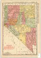
Map showing railroads in Nevada, 1904
Date
1904
Description
Relief shown by hachures. Added title: Rand McNally's new business map of Nevada. Shows range and township grid. Shows railroads. Color used to show boundaries of counties. Includes index to cities. On verso: Indexes to counties, lakes, mountains, rivers, towns, etc. Published by Rand McNally & Co. Scale [ca. 1:1,710,720]. 1 in. equals 27 miles (W 120°--W 114°/N 42°--N 35°). Originally published as pages 263 and 264 of Rand-McNally indexed atlas.
Text
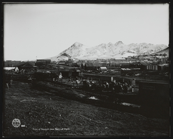
View of Tonopah from Railroad Depot: photograph
Date
1905
Archival Collection
Description
View of Tonopah from the Railroad Depot. Part of the Tonopah R.R. Yard (3) showing freight which has spilled over from depot platform. (note SPC cars 420, 712; Tonopah RR 4-wheel caboose #13) 1905. (photo: State Archives, Museums and Historical Dept.). Stamp on front of photo: "J. E. Stimson, Artist, Cheyenne, WYO. 892" Stamp on back of photo: "Mallory Hope Ferrell P. O. Box 2837 Peachtree City, GA 30269." Stamp on back of photo: "Publication of this photo must give credit line to the Wyoming State Archives, Museums, and Historical Department."
Image
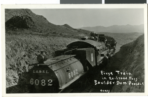
Postcard of a Union Pacific Railroad train, during Hoover Dam construction, late 1920s - early 1930s
Date
1925 to 1935
Archival Collection
Description
A Union Pacific Railroad train as a part of the construction for Hoover Dam. The front of the card reads: "First train in railroad pass, Boulder Dam Project, Oakes." Description given with postcard: "SP, LA & SL (UPRR) locomotive 6082 in Railroad Pass. Maybe spreading ballast on track."
Image
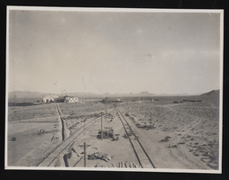
Railroad outside Millers, Nevada: photographic print
Date
1908
Archival Collection
Description
Railroad outside Millers, Nevada in 1908. Inscription with the image reads, "(David Garcia 1-26-90)."
Image

Transcript of interview with Ralph Daly by Charles Malkowski, February 25, 1977
Date
1977-02-25
Archival Collection
Description
Charles Malkowski interviews Ralph Daly (born in Texas in 1903) about his experience of moving to Las Vegas during its early growth. Daly talks specifically about Block 16 and the Arizona Club and the extent of gambling and prostitution that took place there in the early 1900s. Daly, who worked in oil fields but became paralyzed due to an injury, also talks about moving to Las Vegas to make his living on gambling after becoming disabled. He also describes how the construction of Boulder Dam attracted many migrant workers and how, after World War II, Las Vegas attracted tourists and became more of a gambling town as more casinos were built and worldwide advertising for those casinos started. Daly also discusses the end of prostitution in Las Vegas, certain famous gamblers he met, and the forms of cooling used before air conditioning was introduced.
Text
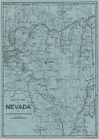
Sketch map of Nevada and the southeastern portion of California, 1906
Date
1906
Description
34 x 24 cm. Relief shown by hachures. Map may be a reprint of a map by George S. Clason, published by the Clason Map Co. in Denver, Colo., in 1906. Map is printed on blue paper. "OPHIR" and a star printed near Pueblo in Nye County. Shows railroad routes.
Image
Pagination
Refine my results
Content Type
Creator or Contributor
Subject
Archival Collection
Digital Project
Resource Type
Material Type
Place
Language
Records Classification
