Search Results
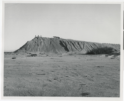
Photograph of Transfer Hill ruins, Death Valley Junction (Calif.), early 1900s
Date
1900 to 1920
Archival Collection
Description
Ruins of mining area with ore deposits, known as Transfer Hill, at Death Valley Junction.
Image
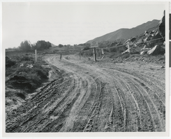
Photograph of closed road and railroad station ruins, Baker (Calif.), early 1900s
Date
1900 to 1920
Archival Collection
Description
Dirt road in the desert is blocked off by chains. A sign next to the closure reads: "Keep Out Closed Area." Inscription with image says: "Ruins of T&T water tower and station may survive at Soda Springs near Baker, California."
Image
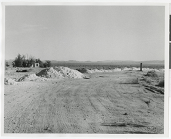
Photograph of dirt area for Silver Lake railroad, Silver Lake (Calif.), early 1900s
Date
1900 to 1920
Archival Collection
Description
Adobe ruins in the desert of Silver Lake, California.
Image
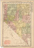
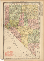
Map showing railroads in Nevada, 1911
Date
1911
Description
Relief shown by hachures. Title below scale: Rand McNally & Co.'s New business atlas map of Nevada. Shows railroads. Includes township and range grid. Includes index to principal cities with population statistics. Includes township and range grid. Index to Nevada counties, lakes, mountains, rivers, towns, etc. on verso. Published by Rand McNally & Co. Scale [ca. 1,710,720]. 1 in. = 27 miles (W 120°--W 114°/N 42°--N 35°). Published as page 321 of Rand-McNally indexed atlas.
Text
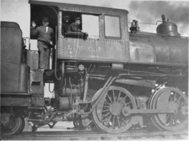
Photograph of southern commuter outside San Diego, circa late 1800s to early 1900s
Date
1880 to 1930
Archival Collection
Description
Description given with photograph: "San Diego southern commuter line outside San Diego. Later electrified."
Image
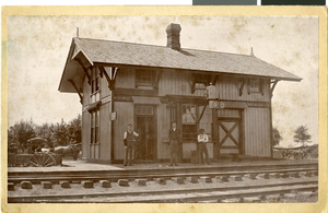
Photograph of men in front of building, Gilliam, Missouri, circa late 1800s to early 1900s
Date
1880 to 1939
Archival Collection
Description
Description provided with image: "Maurine Hubbard (Wilson) was born here March 11, 1898: she was born upstairs over the station. (Gilliam, Missouri)."
Image
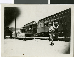
Film transparency of a Las Vegas and Tonopah Railroad Company train car, Las Vegas, circa early 1900s
Date
1900 to 1910
Archival Collection
Description
Black and white image of a railroad engineer inside of a train car for the Las Vegas and Tonopah Railroad Company.
Image

Map of Las Vegas Rancho, Lincoln County, Nevada, September 15, 1904
Date
1904-09-15
Description
'Being part of Township 20 S. R.61 E. MT. D. B.&.M, containing 1864.49 acres. Division engineer's office at the front, AMB, September 15th, 1904. A.L. Jones, Division Engineer. Surveyed by W.G. Watson, Assistant Engineer. Dwg. 30296.' Includes traverse table. Shows land owned by the San Pedro, Los Angeles & Salt Lake Railroad, its right of way and the right of way for the Las Vegas & Tonopah Railroad, land owned by the Las Vegas Land & Water Company including Clark's Las Vegas Townsite with the Bucks Addition and the Wardie Addition, and parcels sold from the Las Vegas Land & Water Company land. Scale: [1:9,600]. 1 in. to 800 feet. Library's copies 1 and 4 have land owned by the San Pedro, Los Angeles & Salt Lake Railroad hand-colored in pink and the rest of the Las Vegas Rancho not owned by the Las Vegas Land & Water Company hand-colored in green. Library's copy 2 has buildings of the Stewart Ranch drawn in and labeled in pencil. Library's copy 3 has addition and subtraction problems in pencil on the verso. Library's copy 4 has "Original purchase--1864.49 acres R.R.C. + L.V.L. + W. Co.--In colors." written in pencil on the verso followed by "(1904)" in red pencil. Library's copy 4 also has label on verson made of brown paper with "No 5 Las Vegas Ranch being part township ( 1904)" typed on it.
Image

Map showing location of the Las Vegas & Tonopah Railroad from Las Vegas to Bullfrog, Nevada, 1906
Date
1906
Archival Collection
Description
'Office of Chief Engineer' printed on map above date.
Image
Map of Nevada Railroads, 1911
Date
1911
Description
Scale [ca. 1,710,720]. 1 in. = 27 miles (W 120 --W 114 /N 42 --N 35 ) ; 1 map : col. ; 47 x 31 cm ; Relief shown by hachures ; Title below scale: Rand McNally & Co.'s New business atlas map of Nevada ; Shows railroads ; Includes additional copyright date: c1893 ; Includes township and range grid ; Published as page 321 of Rand-McNally indexed atlas ;
Image