Search Results
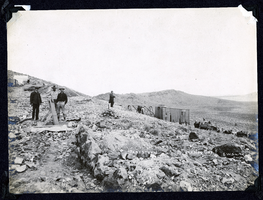
Photograph of men loading ore at Sandstorm Mine, Esmeralda (Nev.), early 1900s
Archival Collection
Description
Caption: Sandstorm Loading Ore
Image
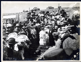
Photograph of a double handed drilling contest, Tonopah (Nev.), July 26, 1904
Date
1906-07-26
Archival Collection
Description
Caption: Drilling contest. Tonopah R.R. Carnival. Tonopah July 26 1904
Image
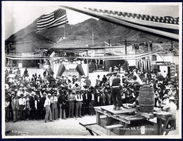
Photograph of people watching the driving of the silver spike at the Tonopah Railroad Carnival, Tonopah (Nev.), early 1900s
Date
Unknown year in the decade of the 1900s
Archival Collection
Description
Photograph of people watching the driving of the silver spike at the Tonopah Railroad Carnival, Tonopah (Nev.), early 1900s
Image
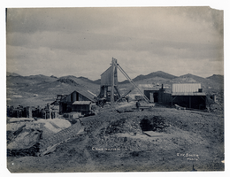
Photograph of Combination Mine, Goldfield (Nev.), early 1900s
Archival Collection
Description
Caption: Combination
Image

Map of the state of Nevada to accompany the annual report of the Commr. Genl. Land Office, October 2, 1866
Date
1866-10-02
Description
'Department of the Interior, General Land Office, October 2nd, 1886, [signed] Jos. S. Wilson, Commissioner.' 'The Major & Knapp Eng. Mfg. & Lith. Co. 71 Broadway, N.Y.' Relief shown by hachures. Hand colored. Shows silver, gold, and copper mines. Scale [1:1,140,480]. 18 miles to an in. (W 120°--W 114°/N 42°--N 35°)
Image

Tonopah, Nevada mining map, March 1904
Date
1904-03
Description
'U.S. Geological Survey, George Otis Smith, Director.' 'R.U. Goode, Geographer in charge. Triangulation by U.S. Coast and Geodetic Survey. Topography by W.J. Peters. Surveyed in 1902-1903.' 'Edition of Mar. 1904, reprinted Apr. 1910.' Oriented with north toward the upper left. Relief shown by contours and hachures. Scale 1:12,000 (W 117°14´--W 117°12´/N 38°05´--N 38°03´)
Text
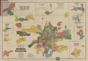
Map of Tonopah Mining District, Nevada, revised edition, 1903
Date
1903
Description
'Compiled and published by Booker & Bradford, engineers, Tonopah, Nevada.' 'Copyrighted by Booker & Bradford 1903.' 'Photo-Lith. Britton & Rey, S.F.' Insets of Ray Mining District, vicinity map of Tonopah Mining District, Utopia Mining District, Tokop Mining District, Weepah Mining District, East Klondike Mining District, Gold Mountain, Tonopah Mining District and Red Mountain. Relief shown by hachures. Includes advertisements. Scale [ca. 1:10,800]. 1 inch to 900 feet.
Image
Map of the 450 foot level of the Mohawk Mine, Goldfield, Nevada, circa 1902-1908
Date
1902 to 1908
Description
'(3rd) 450 Ft. level Mohawk.' Hand-drawn, hand-colored and annotated map showing the 450 foot, or third, level of the Mohawk Mine.
Image
Map of the second level of the Red Top Mine, Goldfield, Nevada, circa 1902-1908
Date
1902 to 1908
Description
'Red Top 2nd level, 575780.' Hand-drawn, hand-colored and annotated map showing the second level of the Red Top Mine.
Image
Map of the 380 foot level of the Combination Mine, Goldfield, Nevada, circa 1902-1908
Date
1902 to 1908
Description
'380 ft. level.' Hand-drawn, hand-colored and annotated map showing the 380 foot level of the Combination Mine.
Image