Search Results
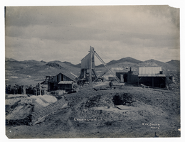
Photograph of Combination Mine, Goldfield (Nev.), early 1900s
Archival Collection
Description
Caption: Combination
Image
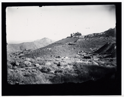
Sunnyside Mine: photographic print
Date
1940 (year approximate)
Archival Collection
Description
From the Nye County, Nevada Photograph Collection (PH-00221) -- Series V. Smoky Valley, Nevada and Round Mountain, Nevada -- Subseries V.C. Lofthouse-Berg Families (Round Mountain).
Image
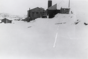
Building located in the vicinity of the Sunnyside Mine: photographic print
Date
1940 (year approximate)
Archival Collection
Description
From the Nye County, Nevada Photograph Collection (PH-00221) -- Series V. Smoky Valley, Nevada and Round Mountain, Nevada -- Subseries V.C. Lofthouse-Berg Families (Round Mountain).
Image
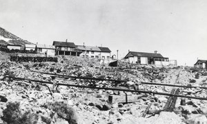
Photograph of the Burke Mine tunnel area and store atop a hill, Pioche (Nev.), 1900-1925
Date
1900 to 1925
Archival Collection
Description
View of Burke Tunnel area-building at top of hill was store for Burke tunnel. #93 on left, some buildings on left remain, 1982. Photo 1900-1910. Pioche, Nev. ID by Vic Cottino/Jerome Sears July 1982
Image
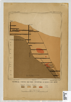
Map of a vertical cross-section through the Eureka Consolidated Mine, Eureka County (Nev.), 1883
Date
1883
Description
Scale [ca. 1:2,400] 1 in.=200 feet1 map ; col. ; 20 x 16 cm ; Eureka Con. Mine is in the Eureka Mining District in Nevada ; "Juliue Bien & Co. lith." ; "U.S. Geological Survey. Annual report 1883, pl. XXXIII"--Upper right margin ; Library's copy has "Nev." printed in pencil in upper right corner
Image
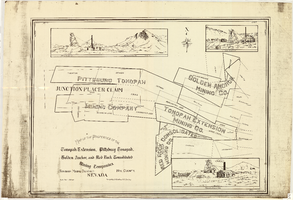
Map of the properties of the Tonopah Extension, Pittsburg Tonopah, Golden Anchor, and Red Rock Consolidated Mining Companies : Tonopah Mining District, Nye County (Nev.), 1901
Date
1901
Description
Scale [ca. 1:2,400] 1 in. to 200 feet ; 1 map ; 75 x 102 cm; Includes locations of mines and their main shafts and drawings of the hoists of the Tonopah Extension, Golden Anchor and the Red Rock Consolidated ; Photocopy. [United States : s.n., 198-?]
Image
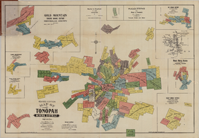
Map of the Tonopah Mining District, Tonopah (Nev.), 1903
Date
1903
Description
Rev. ed. ; Scale [ca. 1:10,800]. 1 inch to 900 feet ; 1 map : col. ; 76 x 102 cm., folded in cover to 21 x 11 cm ; Relief shown by hachures ; Cover title: Map of Tonopah, Gold Mountain and other adjacent mining districts, Nye and Esmeralda Counties ; Insets: Ray Mining District, vicinity map of Tonopah Mining District, Utopia Mining District, Tokop Mining District, Weepah Mining District, East Klondike Mining District, Gold Mountain, Tonopah Mining District and Red Mountain ; "Photo-lith. Britton & Rey, S.F." ; Includes advertisements
Image
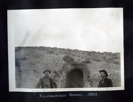
Photograph of Sam Bradburn and J. O'Brien standing at the opening of the Yellowjacket tunnel, Pioneer (Nev.), 1909
Date
1909
Archival Collection
Description
Annotated "Sam. H. Bradbury" [left] and "J. D. O'Brien" [right]
Caption: Yellowjacket Tunnel. 1909.
Caption: Yellowjacket Tunnel. 1909.
Image

Photograph of a man working outside the Dividend Mining Company mill, Tonopah Dividend Mine (Nev.), 1916
Date
1916
Archival Collection
Description
Inscription on back reads: "This picture shows the head of our 2V-HP engine which operated the mill and compressor"
Image
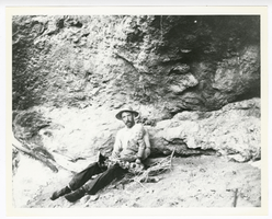
Photograph of O. K. Reed and his son Little O. K. near his claim at Gold Reed, Tonopah (Nev.), 1920
Date
1920
Archival Collection
Description
Photograph of O. K. Reed and his son Little O. K. near his claim at Gold Reed, Tonopah (Nev.), 1920
Image