Search Results
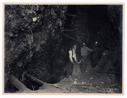
Photograph of men working in mine in Tonopah (Nev.), 1904
Date
1904
Archival Collection
Description
Photograph of men working in mine in Tonopah (Nev.), 1904
Image
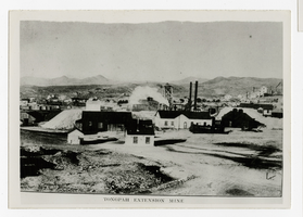
Photograph of Tonopah Extension Mine buildings and headframe, Tonopah (Nev.), 1905
Date
1905
Archival Collection
Description
Photograph of Tonopah Extension Mine buildings and headframe, Tonopah (Nev.), 1905
Image
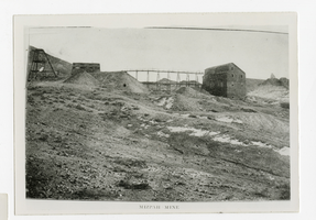
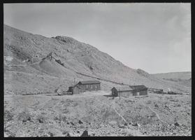
Photograph of Mizpah Mine headframe, trestle and buildings, Mizpah Mine (Nev.), 1905
Date
1905
Archival Collection
Description
Photograph of Mizpah Mine headframe, trestle and buildings, Mizpah Mine (Nev.), 1905
Image
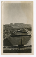
Photograph of a view from Yellow Pine rail ore cars in motion, Goodsprings (Nev.), 1911
Date
1911
Archival Collection
Description
Photograph of a view from Yellow Pine rail ore cars in motion, Goodsprings (Nev.), 1911
Image
Noonday Mine side angle, Tecopa Railroad: photograph
Date
1900 (year approximate) to 1935 (year approximate)
Archival Collection
Description
Noonday Mine (Tecopa Consolidated Mining Co.) 9 miles E. of Tecopa, California on T.R.R.. The stamp on the back of the photo reads: "Mallory Hope Ferrell P. O. Box 2837 Peachtree City, GA 30269."
Image
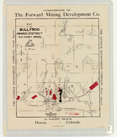
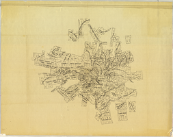
Map of the Bullfrog Mining District, Nye County (Nev.), 1905
Date
1905
Description
Scale [ca. 1:39,000. 1 in. to approx. 3,250 feet] ; 1 map : col. ; 45 x 38 cm ; Relief shown by hachures ; "Compliments of the Forward Mining Development Co." ; Properties owned by Patrick Investment Company are marked in red ; Shows railroads, roads, and pipelines ;
Image
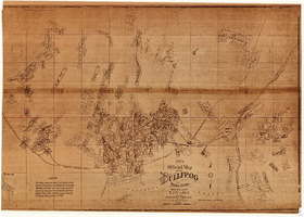
New official map of the Bullfrog Mining District, Nye County (Nev.), 1905
Date
1905
Description
Scale [ca. 1:16,800. 1 inch to approximately 1,400 feet] ; 1 map ; 74 x 109 cm ; Blueline print ; Scale almost illegible ; "Photo. lith. Britton & Rey." ; Photocopy? [United States : s.n., 199-?] ;
Image
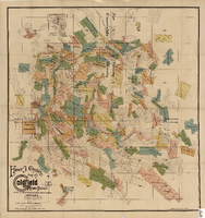
Elmer J. Chute's Map of Goldfield Mining District, Esmeralda and Nye Counties (Nev.), 1905
Date
1905
Description
Scale [ca. 1:20, 400. 1 in.=aprrox. 1,700 feet] ; 1 map : col. ; 60 x 58 cm ; Includes inset location map ; Includes township and range grid ;
Image
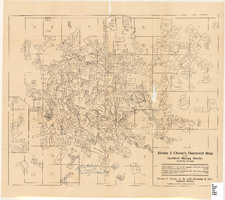
Elmer J. Chute's Diamond Map of the Goldfield Mining District, Esmeralda and Nye Counties (Nev.), 1907
Date
1907
Description
Elmer J. Chute's Diamond Map of the Goldfield Mining District, Esmeralda and Nye Counties (Nev.), 1907
Image
Map of the Tonopah Mining District, Nye County (Nev.), 1905
Date
1905
Description
Scale [ca.1:12,804. 1 in. to approx. 1,067 ft.] ; 1 map ; on sheet 92 x 106 cm ; Relief shown by hachures ; Title supplied by cataloger ; Probably a preliminary black and white edition of the colored map copyrighted by Bradford and Bradford in 1905
Image