Search Results

Photograph of miners at North Star Mine, Tonopah (Nev.), early 1900s
Date
Unknown year in the decade of the 1900s
Archival Collection
Description
Photograph of miners at North Star Mine, Tonopah (Nev.), early 1900s
Image
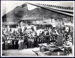
Photograph of a double handed drilling contest, Tonopah (Nev.), July 26, 1904
Date
1906-07-26
Archival Collection
Description
Caption: Drilling contest. Tonopah R.R. Carnival. Tonopah July 26 1904
Image
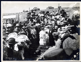
Photograph of people watching the driving of the silver spike at the Tonopah Railroad Carnival, Tonopah (Nev.), early 1900s
Date
Unknown year in the decade of the 1900s
Archival Collection
Description
Photograph of people watching the driving of the silver spike at the Tonopah Railroad Carnival, Tonopah (Nev.), early 1900s
Image
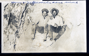
Photograph of Dalta Hurry and Raymond Jefferson in Mohawk Ledge mine, Goldfield (Nev.), early 1900s
Date
1900 to 1925
Archival Collection
Description
Caption: Hurry & Jefferson in same mine
Image
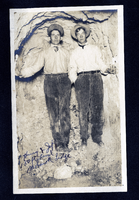
Photograph of Dalta Hurry and Raymond Jefferson in Mohawk Ledge, Goldfield (Nev.), early 1900s
Date
1900 to 1925
Archival Collection
Description
Caption: Hurry & Jeff 150 ft level Mohawk Ledge
Image
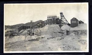
Photograph of the Combination Mill and Mine operations, Goldfield (Nev.), 1900-1920
Date
1900 to 1920
Archival Collection
Description
Photograph of the Combination Mill and Mine operations, Goldfield (Nev.), 1900-1920
Image
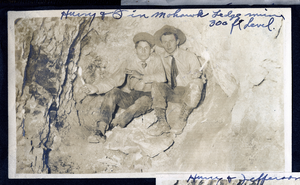
Photograph of Dalta Hurry and C. A. Earle Rinker in Mohawk Ledge mine, Goldfield (Nev.), early 1900s
Date
1900 to 1925
Archival Collection
Description
Caption: Hurry & I in Mohawk Ledge mine 300 ft level.
Image
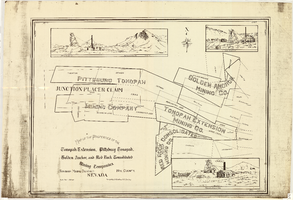
Map of the properties of the Tonopah Extension, Pittsburg Tonopah, Golden Anchor, and Red Rock Consolidated Mining Companies : Tonopah Mining District, Nye County (Nev.), 1901
Date
1901
Description
Scale [ca. 1:2,400] 1 in. to 200 feet ; 1 map ; 75 x 102 cm; Includes locations of mines and their main shafts and drawings of the hoists of the Tonopah Extension, Golden Anchor and the Red Rock Consolidated ; Photocopy. [United States : s.n., 198-?]
Image
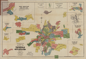
Map of the Tonopah Mining District, Tonopah (Nev.), 1903
Date
1903
Description
Rev. ed. ; Scale [ca. 1:10,800]. 1 inch to 900 feet ; 1 map : col. ; 76 x 102 cm., folded in cover to 21 x 11 cm ; Relief shown by hachures ; Cover title: Map of Tonopah, Gold Mountain and other adjacent mining districts, Nye and Esmeralda Counties ; Insets: Ray Mining District, vicinity map of Tonopah Mining District, Utopia Mining District, Tokop Mining District, Weepah Mining District, East Klondike Mining District, Gold Mountain, Tonopah Mining District and Red Mountain ; "Photo-lith. Britton & Rey, S.F." ; Includes advertisements
Image

Longitudinal section map, Montana Tonopah Mine, circa 1900s-1910s
Date
1900 to 1919
Description
'Longitudinal Section, Montana Tonopah Mine showing workings projected on east-west vertical plane.' In lower right corner: 'E.D. North E.M.' 'Photo-litho. Britton & Rey, S.F.'
Image