Search Results
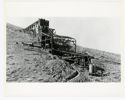
Photograph of Josiah Irving Crowell's mill at the Chloride Cliff Mine (Nev.), 1915
Date
1915
Archival Collection
Description
Photograph of Josiah Irving Crowell's mill at the Chloride Cliff Mine (Nev.), 1915
Image
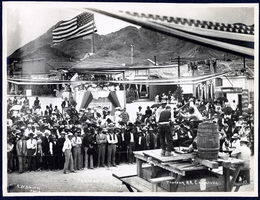
Photograph of a double handed drilling contest, Tonopah (Nev.), July 26, 1904
Date
1906-07-26
Archival Collection
Description
Caption: Drilling contest. Tonopah R.R. Carnival. Tonopah July 26 1904
Image

Photograph of a man working outside the Dividend Mining Company mill, Tonopah Dividend Mine (Nev.), 1916
Date
1916
Archival Collection
Description
Inscription on back reads: "This picture shows the head of our 2V-HP engine which operated the mill and compressor"
Image
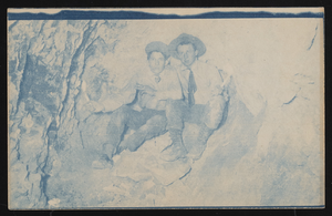
Two men in a mine: photographic print
Date
1900 (year approximate) to 1915 (year approximate)
Archival Collection
Description
Two men in a mine; Rinker is on the right.
Image
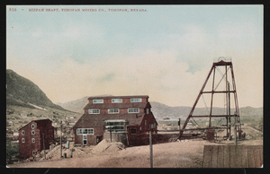
Mizpah Mine shaft: postcard
Date
1900 (year approximate) to 1915 (year approximate)
Archival Collection
Description
Tinted postcard of the Mizpah Mine shaft of the Tonopah Mining Company.
Image
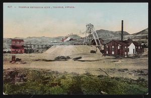
The Tonopah Extension Mine: postcard
Date
1900 (year approximate) to 1915 (year approximate)
Archival Collection
Description
Postcard of the Tonopah Extension Mine.
Image
Frederickson Family Papers
Identifier
MS-00448
Abstract
The Frederickson Family Papers (1904-1917) contain documents and photographs related to Goodsprings, Nevada settlers John C. and Elizabeth Frederickson. Materials include bank statements, mining statements, personal correspondence, and college notes.
Archival Collection
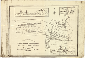
Map of the properties of the Tonopah Extension, Pittsburg Tonopah, Golden Anchor, and Red Rock Consolidated Mining Companies : Tonopah Mining District, Nye County (Nev.), 1901
Date
1901
Description
Scale [ca. 1:2,400] 1 in. to 200 feet ; 1 map ; 75 x 102 cm; Includes locations of mines and their main shafts and drawings of the hoists of the Tonopah Extension, Golden Anchor and the Red Rock Consolidated ; Photocopy. [United States : s.n., 198-?]
Image
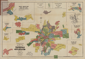
Map of the Tonopah Mining District, Tonopah (Nev.), 1903
Date
1903
Description
Rev. ed. ; Scale [ca. 1:10,800]. 1 inch to 900 feet ; 1 map : col. ; 76 x 102 cm., folded in cover to 21 x 11 cm ; Relief shown by hachures ; Cover title: Map of Tonopah, Gold Mountain and other adjacent mining districts, Nye and Esmeralda Counties ; Insets: Ray Mining District, vicinity map of Tonopah Mining District, Utopia Mining District, Tokop Mining District, Weepah Mining District, East Klondike Mining District, Gold Mountain, Tonopah Mining District and Red Mountain ; "Photo-lith. Britton & Rey, S.F." ; Includes advertisements
Image
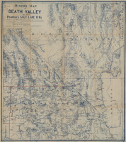
Miners map of Death Valley and the proposed Salt Lake railroads, January 1903
Date
1903-01
Description
Subtitle: 'Including portions of San Bernardino and Inyo Counties, California; Nye and Lincoln Counties, Nevada and Mojave County, Arizona.' 'Compiled and drawn by A. Russell Crowell.' 'May 1902 (Corrected to Jan. 1903.' 'Property of H. Kehoe' written in ink in upper left corner. Scale [ca. 1:506,880]. 1 in. to 8 miles (W 118?--W 114?/N 38?--N 35?). Relief shown by hachures and spot heights. Blueline print. Library's copy has types of minerals found in different areas hand-printed in red and has red lines hand-drawn along county boundaries. G4351.H1 1903 .C76
Image