Search Results
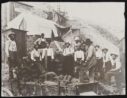
Miners with sacked ore in Rawhide, Nevada: photographic print
Date
1909 (year approximate)
Description
From the Nan Doughty Photograph Collection (PH-00240). Shaffer Lease, Grutt Hill Mill.
Image
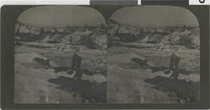
Photograph of mining views at night, Goldfield, Nevada, circa 1903
Date
1900 to 1930
Archival Collection
Description
Stereoview of Goldfield, Nevada taken by Olaf P. Larson. The images are mining views taken at night.
Image

Photograph of mining views at night, Goldfield, Nevada, circa 1903
Date
1900 to 1930
Archival Collection
Description
Stereoview of Goldfield, Nevada taken by Olaf P. Larson. The images are mining views taken at night.
Image
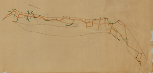
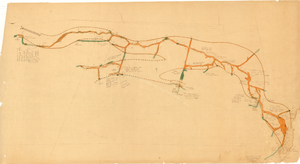
Map of the second level of the Red Top Mine, Goldfield, Nevada, circa 1902-1908
Date
1902 to 1908
Description
'Red Top 2nd level, 575780.' Hand-drawn, hand-colored and annotated map showing the second level of the Red Top Mine.
Image
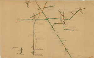
Map of the 380 foot level of the Combination Mine, Goldfield, Nevada, circa 1902-1908
Date
1902 to 1908
Description
'380 ft. level.' Hand-drawn, hand-colored and annotated map showing the 380 foot level of the Combination Mine.
Image
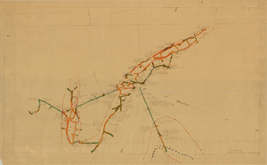
Map of the third level of the Red Top Mine, Goldfield, Nevada, circa 1902-1908
Date
1902 to 1908
Description
'Red Top 3rd level, 5659.90.' Hand-drawn, hand-colored and annotated map showing the third level of the Red Top Mine.
Image

Map of the 328 foot level of the Combination Mine, Goldfield, Nevada, circa 1902-1908
Date
1902 to 1908
Description
Hand-drawn, hand-colored and annotated map showing the 328 foot level of the Combination Mine.
Image
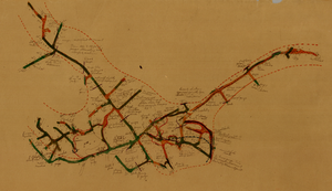
Map of the 130 foot level of the Combination Mine, Goldfield, Nevada, circa 1902-1908
Date
1902 to 1908
Description
'130 ft. level. Combination Mine.' 'Scale 1 in.=40 ft.' Hand-drawn, hand-colored and annotated map showing the 130 foot level of the Combination Mine.
Image
Map of the 330 foot level of the Combination Mine, Goldfield, Nevada, circa 1902-1908
Date
1902 to 1908
Description
Hand-drawn, hand-colored and annotated map showing the 330 foot level of the Combination Mine.
Image
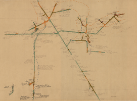
Map of the 380 foot level of the Locke Mine, Goldfield, Nevada, circa 1902-1908
Date
1902 to 1908
Description
'380 ft. level.' Hand-drawn, hand-colored and annotated map showing the 380 foot level of the Locke Mine.
Image