Search Results

Map of Las Vegas, Nevada and surrounding Bureau of Land Management areas to the west and north, 1994
Date
Description
Text

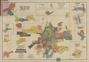
Tonopah, Nevada mining map, March 1904
Date
Description
Text
Map of Tonopah Mining District, Nevada, revised edition, 1903
Date
Description
Image

Map of the state of Nevada to accompany the annual report of the Commr. Genl. Land Office, October 2, 1866
Date
Description
Image
Nevada Mining Photograph Collection
Identifier
Abstract
The Nevada Mining Photograph Collection depicts mining activities, miners, and mining towns in Nevada from 1868 to 1937. The photographs primarily depict the towns of Tonopah, Nevada and Goldfield, Nevada, including mills, buildings, mine shafts, and panoramic views of the landscape. The photographs also depict Beatty, Lost City, Delamar, Candelaria, Winnemucca, Virginia City, Rhyolite, Elko, and Reno, Nevada. The photographs also include portraits of early settlers in Nevada, Native Americans, children, parades, celebrations, and funerals.
Archival Collection
UNLV University Libraries Collection on Nevada Mining
Identifier
Abstract
The Nevada Mining Collection is comprised of records that document mining and mines in Nevada from 1842 to 1966. The majority of the collection includes records of various mines and mining companies located in the Esmeralda, Lincoln, Clark, White Pine, and Nye counties, dating from 1900 to 1928. The collection includes financial, administrative, and business related records; photographs of miners, mining camps, and towns; correspondence; maps; newspaper clippings, pamphlets, newsletters, and booklets.
Archival Collection
Nevada Historical Society Photograph Collection
Identifier
Abstract
The Nevada Historical Society Photograph Collection contains photographs of Nevada from 1873 to 1951. The photographs primarily depict the towns of Pioche, Candelaria, and Tonopah in the early-twentieth century. The photographs also depict Nevada Governor Emmett D. Boyle and U.S. Senators William M. Stewart and Key Pittman. The collection contains two images related to the Women's Suffrage movement, including Governor Boyle signing a resolution in favor of the Nineteenth Amendment to the U.S. Constitution and Anne Martin's campaign for the U.S. Senate in 1918. Lastly, the photographs also depict mining operations in Bullionville and Candelaria.
Archival Collection
Nye County, Nevada Photograph Collection
Identifier
Abstract
The Nye County, Nevada Photograph Collection contains photographs from Nye County, Nevada from 1880 to 1990. The collection includes a wide variety of photographs that document the activities, landmarks, geographical features, towns, ranches, and families of Nye County. The collection covers the areas of Amargosa Valley, Ash Meadows, Beatty, Duckwater, Gabbs, Goldfield, Kawich Mountains, Manhattan, Pahrump, Round Mountain, Rhyolite, Smoky Valley, Springdale, Tecopa, Tonopah, and Twin Springs. The activities documented include mining, prospecting, herding animals, schooling, ranching, building construction, railroad construction, and hunting and fishing.
Archival Collection
Frank Williams Papers on Early Nevada
Identifier
Abstract
The Frank Williams Papers on Early Nevada (1892-1946) consists of manuscripts written for the most part by Frank Williams, an early resident of Southern Nevada. The collection includes Williams' autobiography as well as histories of Goodsprings, Potosi Mine, Mesquite Valley, and the Yellow Pine Mining districts. Finally, this collection contains reports and material reflecting Frank Williams' two terms as University Regent (1909-1912 and 1923-1942) at the University of Nevada, Reno, and his four terms in the Nevada State Assembly.
Archival Collection
UNLV Libraries Collection of Nevada Mining Maps
Identifier
Abstract
The UNLV Libraries Collection of Nevada Mining Maps (approximately 1860-1950) consists of various maps depicting mines, shafts, and mining claims primarily in Southern Nevada.
Archival Collection