Search Results
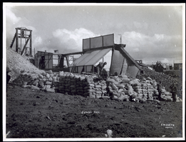
Photograph of workers piling sacks of ore from the Jumbo Mine, Goldfield (Nev.), early 1900s
Archival Collection
Description
Caption: Jumbo Ore
Image
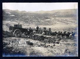
Photograph of men loading sacks of ore onto wagon at Richards Lease, Goldfield (Nev.), early 1900s
Archival Collection
Description
Caption: Richards. Lease. Jumbo. No. 23.
Image
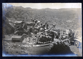
Photograph of men loading sacks of ore onto wagons at Florence Mine, Goldfield (Nev.), early 1900s
Archival Collection
Description
Caption: No. 19. Florence. Mine.
Image
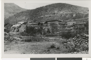
Photograph of Mill, San Jose de Gracia (Mex.), 1900-1930
Date
1900 to 1930
Archival Collection
Description
Mine mill and hacienda in San Jose de Gracia, Sinaloa, Mexico.
Image
Photograph of Techatticup Mine in El Dorado Canyon, circa early to mid 1900s
Date
1900 to 1930
Archival Collection
Description
Handwritten description provided on back of image: "Tchatticup [sic] Mine, El Dorado Canyon."
Image
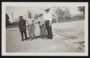
Photograph of Harold and Geraldine Stocker with others, Overton (Nev.), approximately 1900-1950
Date
1900 to 1950
Archival Collection
Description
Group poses outdoors on dirt path at the "Silica mine" in Overton. Identified from left to right: "Harold, Geraldine, mother, with two unidentified persons."
Image

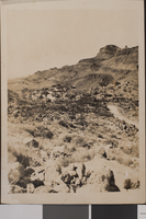
Photograph of Transfer Hill ruins, Death Valley Junction (Calif.), early 1900s
Date
1900 to 1920
Archival Collection
Description
Ruins of mining area with ore deposits, known as Transfer Hill, at Death Valley Junction.
Image

Tonopah, Nevada mining map, March 1904
Date
1904-03
Description
'U.S. Geological Survey, George Otis Smith, Director.' 'R.U. Goode, Geographer in charge. Triangulation by U.S. Coast and Geodetic Survey. Topography by W.J. Peters. Surveyed in 1902-1903.' 'Edition of Mar. 1904, reprinted Apr. 1910.' Oriented with north toward the upper left. Relief shown by contours and hachures. Scale 1:12,000 (W 117°14´--W 117°12´/N 38°05´--N 38°03´)
Text
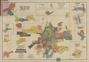
Map of Tonopah Mining District, Nevada, revised edition, 1903
Date
1903
Description
'Compiled and published by Booker & Bradford, engineers, Tonopah, Nevada.' 'Copyrighted by Booker & Bradford 1903.' 'Photo-Lith. Britton & Rey, S.F.' Insets of Ray Mining District, vicinity map of Tonopah Mining District, Utopia Mining District, Tokop Mining District, Weepah Mining District, East Klondike Mining District, Gold Mountain, Tonopah Mining District and Red Mountain. Relief shown by hachures. Includes advertisements. Scale [ca. 1:10,800]. 1 inch to 900 feet.
Image
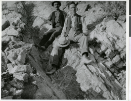
Photograph of Ed Von Tobel, Sr. exploring a mining claim, Las Vegas Region, circa 1900s
Date
1900 to 1909
Archival Collection
Description
Ed Von Tobel, Sr. and (possibly) Tony Felix on an exploring trip for mining claims in mountains surrounding Las Vegas. Physical object has an insert containing additional biographical information.
Image