Search Results
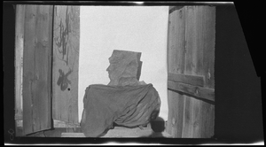
Mine entrance with rock face, image 001 of 002: photographic film
Date
1878 to 1954
Archival Collection
Description
Entrance to a mine, location unknown. A rock sits at the entrance that looks like the profile of a face on the left.
Image
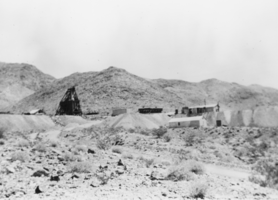
View of Salt mine: photographic print
Date
1870 (year approximate) to 1979 (year approximate)
Archival Collection
Description
From the KLVX Steamboats on the Colorado Photograph Collection (PH-00156). Written on photo sleeve: "Salt mine. (Colorado River area)." Handwritten on verso: "Courtesy Special Collections UNLV."
Image
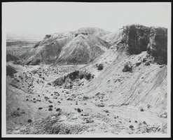
Standard Slag Mine and Mile above Tecopa, California: photographic print
Date
1890 (year approximate) to 1980 (year approximate)
Archival Collection
Description
From the Nye County, Nevada Photograph Collection (PH-00221) -- Series I. Amargosa Valley, Nevada -- Subseries I.B. Records Family.
Image
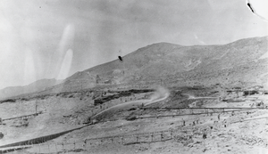
Placer miners using hydraulic methods: photographic print
Date
1909 (year uncertain) to 1988 (year uncertain)
Archival Collection
Description
From the Nye County, Nevada Photograph Collection (PH-00221) -- Series V. Smoky Valley, Nevada and Round Mountain, Nevada -- Subseries V.C. Lofthouse-Berg Families (Round Mountain).
Image
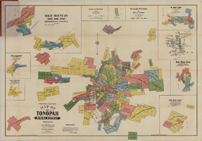
Map of Tonopah Mining District, Nevada, revised edition, 1903
Date
1903
Description
'Compiled and published by Booker & Bradford, engineers, Tonopah, Nevada.' 'Copyrighted by Booker & Bradford 1903.' 'Photo-Lith. Britton & Rey, S.F.' Insets of Ray Mining District, vicinity map of Tonopah Mining District, Utopia Mining District, Tokop Mining District, Weepah Mining District, East Klondike Mining District, Gold Mountain, Tonopah Mining District and Red Mountain. Relief shown by hachures. Includes advertisements. Scale [ca. 1:10,800]. 1 inch to 900 feet.
Image
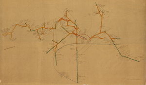
Map of the 450 foot level of the Mohawk Mine, Goldfield, Nevada, circa 1902-1908
Date
1902 to 1908
Description
'(3rd) 450 Ft. level Mohawk.' Hand-drawn, hand-colored and annotated map showing the 450 foot, or third, level of the Mohawk Mine.
Image
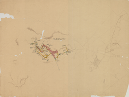
Map of the 280 foot level of the Combination Mine, Goldfield, Nevada, circa 1902-1908
Date
1902 to 1908
Description
Hand-drawn, hand-colored and annotated map showing the 280 foot level of the Combination Mine. Printed on map: 'Mohawk, col. el. 5958.48; Hayes & Monnette No. 2, col. el. 5935.7; Hayes & Monnette No. 1, col. el. 5925.8; Truett, col. el. 5938.8; Combination, col. el. 5986.31.'
Image
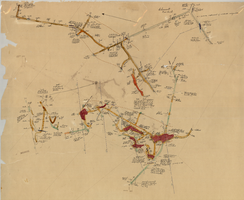
Map of the 600 foot, or third, level of the Clermont Mine, Goldfield, Nevada, circa 1902-1908
Date
1902 to 1908
Description
Hand-drawn, hand-colored and annotated map showing the 600 foot, or third, level of the Clermont Mine. Handwritten at top of map: 'Clermont, 3rd level.'
Image
Letter from C. A. Earle Rinker to his mother, September 6, 1908
Date
1908-09-06
Archival Collection
Description
Letter from C. A. Earle Rinker to his mother, September 6, 1908
Text
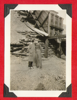
Probably Clara Bow (and Rex?) outside a mine shaft: photographic print
Date
1880 to 1979
Archival Collection
Description
Bell Family Scrapbook scanning, Set 4, proofed 11.04.2010 Clara Bow and unidentified man at mining site
Possibly Rex Bell
Image