Search Results
Stratosphere Tower compared to Seven Wonders of the United States: video
Date
Archival Collection
Description
Las Vegas, Nevada news broadcast revealing Hoover Dam as one of the Seven Wonders of the United States as named by civil engineers; Weathercaster Nathan Tannenbaum comments the Stratosphere Tower when completed will join this list. Original media VHS, color, aspect ratio 4 x 3, frame size 720 x 486. From the Bob Stupak Professional Papers (MS-01016) -- Professional papers -- Audiovisual material -- Digitized audiovisual clips file.
Moving Image
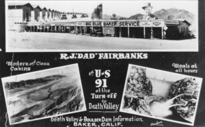
Composite: Baker, California service station on the west Side of the Tonopah and Tidewater Railroad track; Death Valley; Hoover Dam, Nevada: photographic print
Date
Archival Collection
Description
From the Nye County, Nevada Photograph Collection (PH-00221) -- Series VII. Other areas in Nye County -- Subseries VII.F. Lowe Family. The top photo, a composite, was taken about 1928, when R.J. "Dad" Fairbanks first moved to Baker and established a service station on the west Side of the Tonopah and Tidewater Railroad tracks. Photo on the bottom left Shows Death Valley; on the right is a photo of Hoover Dam.
Image

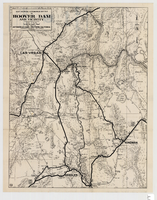
Map of Boulder Dam area and Las Vegas, Nevada, October 7, 1930
Date
Description
Text
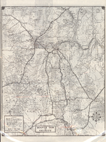
Map showing automobile routes to Hoover Dam and vicinity, circa 1934
Date
Description
Image
Road map of Hoover Dam and vicinity, circa 1949
Date
Description
Text
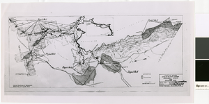
Map of irrigable areas near Boulder Dam, February 20, 1935
Date
Archival Collection
Description
Image
Robert Woodruff Photograph Collection
Identifier
Abstract
The Robert Woodruff Photograph Collection (1900s-1970s) consists of ninety-seven black-and-white photographs of locations and events in Clark County, Nevada. Locations include Las Vegas, Henderson, and Searchlight, Nevada, as well as the Hoover Dam. The majority of the images were taken between 1934 and 1962.
Archival Collection
Boulder City 31ers Photograph Collection
Identifier
Abstract
The Boulder City 31ers Photograph Collection depicts the construction of the Hoover (Boulder) Dam and the development of Boulder City, Nevada from 1930 to 1987. The photographs primarily depict construction of the Hoover Dam, but they also depict workers, dormitories, the Colorado River, stores, and Black Canyon.
Archival Collection
Jamey Stillings Photographs
Identifier
Abstract
The Jamey Stillings Photographs (2009-2024) is primarily comprised of photographs taken by professional photographer, Jamey Stillings documenting various infrastructure projects in the region. The Mike O’Callaghan-Pat Tillman Memorial Bridge project at the Hoover Dam depicts the construction of the Mike O’Callaghan-Pat Tillman Memorial Bridge from 2009 to 2012. The Ivanpah Solar Electric Generating System project depicts aerial views of Ivanpah Solar in the Mojave Desert of California from 2010 to 2014. The Crescent Dunes Solar project consists of a range of aerial and ground-based work documenting SolarReserve's Crescent Dunes Solar near Tonopah, Nevada, from 2014 to 2015. The
Archival Collection
Irving Hirshon Photographs
Identifier
Abstract
The Irving Hirshon Photographs are comprised of 55 color slide photographs taken by Irving Hirshon in 1971 of Lake Mead, Hoover Dam, downtown Las Vegas, and the Las Vegas Strip. Hirshon is believed to have taken the slides in the summer of 1971 on a West Coast trip to celebrate his twenty-fifth wedding anniversary.
Archival Collection