Search Results
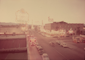
Film transparency of aerial view of Fremont Street (Las Vegas), circa 1947
Date
Archival Collection
Description
Aerial view of Fremont Street looking northwest from east of Second Street. Neon signs for Bentley's Western Trading Post, the Golden Nugget, the Eldorado Club, the Hotel Apache, the Boulder Club, Club Savoy, and the Pioneer Club are visible. A Shell gasoline station is on the northeast corner of Fremont and Second Streets.
Site Name: Fremont Street
Address: Fremont street, Las Vegas, NV
Image
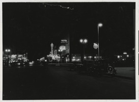
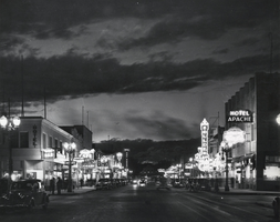
Photograph of Fremont Street with the Hotel Apache in the foreground (Las Vegas), 1940
Date
Archival Collection
Description
Fremont Street at night with the Hotel Apache in the foreground, showing the beginnings of "Glitter Gulch."
Site Name: Fremont Street
Address: Fremont street, Las Vegas, NV
Image
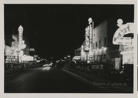
Photograph of Fremont Street at night (Las Vegas), 1938
Date
Archival Collection
Description
Photograph looking west down Fremont Street from 1st Street. Embossed on front of photo: "Glenn A. Davis, Photographer."
Site Name: Fremont Street
Address: Fremont street, Las Vegas, NV
Image

Photograph of a parade on Fremont Street (Las Vegas), 1956
Date
Archival Collection
Description
Parade on Fremont Street showing views of the façades of the Pioneer Club, California Club and others. Stamped on original: "Please credit Union Pacific Railroad Photo, Public Relations Department, 422 West 6th St., Los Angeles 14, Calif, File Print Stock, Los Angeles Neg."
Site Name: Fremont Street
Address: Fremont street, Las Vegas, NV
Image
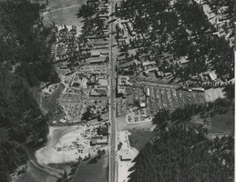
Aerial photograph of Harrah's Stateline Club and Harrah's Tahoe (Stateline, Nev.), circa 1958
Date
Archival Collection
Description
Aerial view of Harrah's Tahoe (under construction on the left side of Highway 50) and Harrah's Stateline Club and Harvey's Tahoe (right side of Highway 50) from the north. At this time, Harrah's Tahoe was Harrah's Stateline Country Club.
Site Name: Harrah's Tahoe
Address: 15 Highway 50
Image
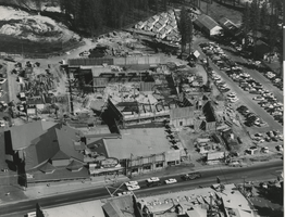
Aerial photograph of Harrah's Stateline Country Club under construction, Stateline, Nev., 1958
Date
Archival Collection
Description
Aerial View of Harrah's Stateline Country Club under construction. Harrah's Stateline Country Club would later become Harrah's Tahoe.
Site Name: Harrah's Tahoe
Address: 15 Highway 50
Image
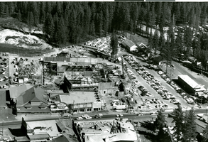
Aerial photograph of Harrah's Stateline Country Club under construction, circa 1958
Date
Archival Collection
Description
Aerial View of Harrah's Stateline Country Club under construction. The country club would later become Harrah's Tahoe.
Site Name: Harrah's Tahoe
Address: 15 Highway 50
Image
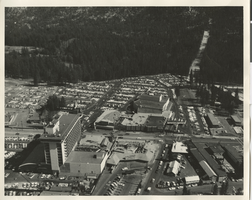
Aerial photograph of Harrah's Tahoe and Harrah's Stateline Club (Stateline, Nev.), 1961
Date
Archival Collection
Description
Aerial view of Harrah's Stateline Club adjacent to Harvey's Tahoe (lower left of photo) and Harrah's Tahoe (center of photo) on either side of Highway 50. Handwritten on original: "Air view 1961."
Site Name: Harrah's Tahoe
Address: 15 Highway 50
Image
Photograph of Fremont Street, Las Vegas, 1940
Date
Archival Collection
Description
Image
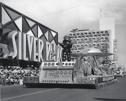
Photograph of the Sands Hotel's space-themed float in the Helldorado Days parade, Las Vegas, circa 1950
Date
Archival Collection
Description
Image