Search Results
Automobile equipment - purchase one new Chevrolet sedan
Date
Archival Collection
Description
Text
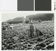
Photograph of Bill Tomiyasu and his children standing in his lettuce patch, Las Vegas, 1923
Date
Archival Collection
Description
Kiyo, Bill, and Nanyu Tomiyasu in their lettuce field.
Transcribed Notes: Transcribed from photo sleeve: "Tomiyasu Farm, Las Vegas, Nevada, 1923. Lettuce patch. L-R: Kiyo, Bill, and Nanyu Tomiyasu. Pioneering farmer Bill Tomiyasu provided much of the fresh vegetables for the Las Vegas and the surrounding area from the 1910s to the 1940s. (Kiyo and Nanyu were his children."
Image
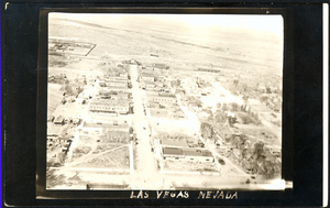
Aerial photograph of Las Vegas, westward direction, circa 1920
Date
Archival Collection
Description
Aerial view of Las Vegas
Image
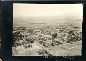
Aerial photograph of Las Vegas, northwest direction, circa 1920
Date
Archival Collection
Description
Aerial view of Las Vegas
Image
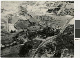
Aerial photograph of Cashman Field and remains of the Mormon Fort, 1960
Date
Archival Collection
Description
Aerial view of Cashman Field and Old Mormon Fort looking southeast.
Image
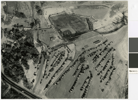
Aerial photograph of Cashman Field and remains of the Mormon Fort looking northeast, 1960
Date
Archival Collection
Description
Aerial view of Cashman Field and Old Mormon Fort looking northeast.
Image
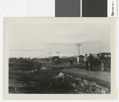
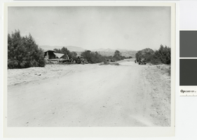
Photograph of road washout five miles southeast of Las Vegas, circa 1931
Date
Archival Collection
Description
Washout at 4-mile on the Boulder Highway, about 5 miles southeast of Las Vegas.
Transcribed Notes: Notes on photo sleeve: 'New pavement finished in May. Cloudburst in October took out culvert. Took out a Chevrolet and a Packard. About 5 mi. southeast of Las Vegas.' (James J. Hester, quote from W.A. Davis)
Image
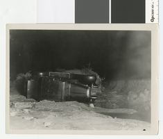
Photograph of cars overturned by a 4 mile cloudburst flood, circa 1931
Date
Archival Collection
Description
Car overturned by flood at 4-mile on the Boulder Highway, about 5 miles southeast of Las Vegas
Transcribed Notes: Handwritten collection note on back of photo: Cars overturned by cloudburst flood near wash by present-day Showboat. c. 1931-1932; Notes on photo sleeve: 'Photo taken at night with flash. Probably Chevrolet wrecked in flood in Vegas Wash. Water was 4 ft. deep on pavement.' (W.A. Davis, photographer)
Image
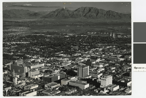
Aerial photograph of downtown Las Vegas looking east toward Frenchman Mountain, post-1953
Date
Archival Collection
Description
Aerial view of downtown Las Vegas looking east toward Frenchman Mountains. The following buildings are visible in the photograph: Lucky Casino, Horseshoe Casino, Fremont Hotel and Casino, Four Queens Casino, Golden Nugget, El Cortez Hotel, First National Bank, Bank of Nevada.
Transcribed Notes: Transcribed from photo sleeve: "Aerial view of Downtown Las Vegas"
Image
Photograph of crew dismantling a house in St. Thomas, 1938
Date
Archival Collection
Description
Crew dismantling a house in St. Thomas
Transcribed Notes: Transcribed from photo sleeve: "Tearing down a house in St. Thomas, NV"
Image