Search Results
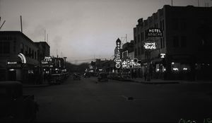
Film transparency of Fremont Street, Las Vegas, Nevada, at dusk, circa 1932
Date
Archival Collection
Description
Looking northwest at dusk from the intersection of Fremont and Second Streets, Las Vegas, Nevada. The Hotel Apache, Apache Café and Apache Casino are seen on the northern side of the street, next to the Boulder Club. The Mission Bar is seen on the southwest corner, next to the Oasis Café.
Site Name: Fremont Street
Address: Fremont street, Las Vegas, NV
Image
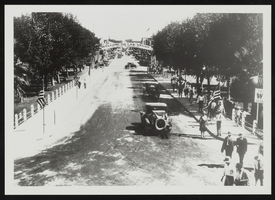
Crowd gathering for President Roosevelt's arrival to Boulder City, Nevada: photographic print
Date
Archival Collection
Description
Image
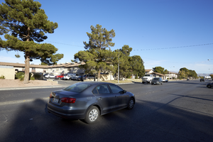
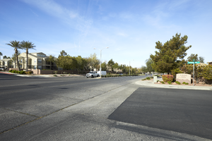
Civic Center Drive with cars and apartments in North Las Vegas, Nevada: digital photograph
Date
Archival Collection
Description
From the UNLV University Libraries Photographs of the Development of the Las Vegas Valley, Nevada (PH-00394). Part of the collection documents the entire 19 mile length of the north/south Eastern Avenue / Civic Center Drive alignment. This photograph was captured in the section of Civic Center Drive between Alexander Road and Cheyenne Avenue.
Image
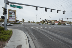
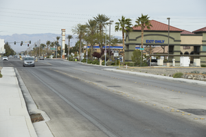
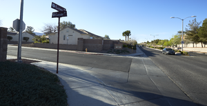
The intersection of Eastern and Richmar Avenues, looking south-southwest in Henderson, Nevada: digital photograph
Date
Archival Collection
Description
From the UNLV University Libraries Photographs of the Development of the Las Vegas Valley, Nevada (PH-00394). Part of the collection documents the entire 19 mile length of the north/south Eastern Avenue / Civic Center Drive alignment. This photograph was captured in the section of Eastern Avenue between Pebble Road and Silverado Ranch Boulevard.
Image
Serene Avenue near Eastern Avenue, looking west in Henderson, Nevada: digital photograph
Date
Archival Collection
Description
From the UNLV University Libraries Photographs of the Development of the Las Vegas Valley, Nevada (PH-00394). Part of the collection documents the entire 19 mile length of the north/south Eastern Avenue / Civic Center Drive alignment. This photograph was captured in the section of Eastern Avenue between Pebble Road and Silverado Ranch Boulevard.
Image
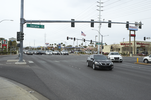
The intersection of Eastern and Serene Avenues, looking south-southwest in Henderson, Nevada: digital photograph
Date
Archival Collection
Description
From the UNLV University Libraries Photographs of the Development of the Las Vegas Valley, Nevada (PH-00394). Part of the collection documents the entire 19 mile length of the north/south Eastern Avenue / Civic Center Drive alignment. This photograph was captured in the section of Eastern Avenue between Pebble Road and Silverado Ranch Boulevard.
Image
Sunridge Heights Parkway at Dashwood Street, looking southwest in Henderson, Nevada: digital photograph
Date
Archival Collection
Description
From the UNLV University Libraries Photographs of the Development of the Las Vegas Valley, Nevada (PH-00394). Part of the collection documents the entire 19 mile length of the north/south Eastern Avenue / Civic Center Drive alignment. This photograph was captured in the section of Eastern Avenue between Coronado Center Drive and Sunridge Heights Parkway.
Image
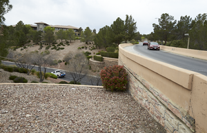
Eastern Avenue overpass at Anthem Parkway, looking south in Henderson, Nevada: digital photograph
Date
Archival Collection
Description
From the UNLV University Libraries Photographs of the Development of the Las Vegas Valley, Nevada (PH-00394). Part of the collection documents the entire 19 mile length of the north/south Eastern Avenue / Civic Center Drive alignment. This photograph was captured in the section of Eastern Avenue between Sunridge Heights Parkway and Grand Hills Drive.
Image
Intersection of Eastern and Evensville Avenues, looking south-southeast in Henderson, Nevada: digital photograph
Date
Archival Collection
Description
From the UNLV University Libraries Photographs of the Development of the Las Vegas Valley, Nevada (PH-00394). Part of the collection documents the entire 19 mile length of the north/south Eastern Avenue / Civic Center Drive alignment. This photograph was captured in the section of Eastern Avenue between Grand Hills and Sun City Anthem Drives.
Image
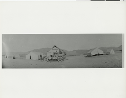
Photograph of Albert Revert and other men with an automobile at a camp, Gold Center, Nevada, 1905
Date
Archival Collection
Description
Image