Search Results
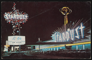
The Stardust Hotel and Casino in Las Vegas, Nevada: postcard
Date
1940 (year approximate) to 1990 (year approximate)
Archival Collection
Description
From Harvey's Hotel and Casino Postcard Collection (PH-00367)
Image
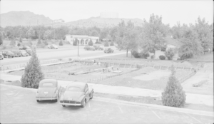
Film transparency of construction in Boulder City, Nevada, circa 1942-1940s
Date
1942 to 1949
Archival Collection
Description
The view of an unidentified building being constructed in Boulder City. In the background of the photo the Shell Station can be seen on the corner of Nevada Way and Arizona Street.
Image
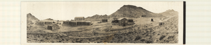
Panoramic photograph of mining buildings in Gilbert, Nevada, circa 1910s-1920s
Date
1910 to 1929
Archival Collection
Description
Panoramic view of wooden buildings and automobiles in the desert in Gilbert, Esmeralda County, Nevada, 25 miles west of Tonopah, near the Monte Cristo Range of mountains.
Image
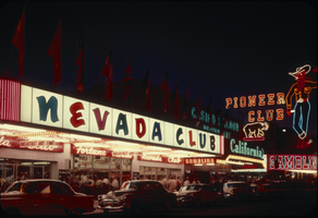
Slide of the Nevada Club, Las Vegas, circa late 1950s-1960s
Date
1958 to 1969
Archival Collection
Description
An image showing an exterior view of the Nevada Club's neon signs at night in downtown Las Vegas. The Pioneer Club and Vegas Vic sign are visible in the background.
Image
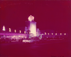
Film transparency of the entrance of the Royal Nevada (Las Vegas), between 1955-1959
Date
1955 to 1959
Archival Collection
Description
nighttime view of the front exterior and entrance of the Royal Nevada resort and casino. The Royal Nevada was eventually incorporated into the Stardust Resort and Casino.
Site Name: Royal Nevada
Address: 3000 Las Vegas Boulevard South
Image
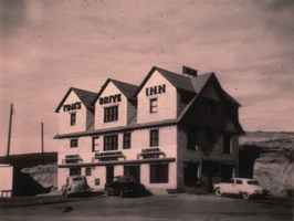
Slide of Tom's Drive Inn, Elko, Nevada, circa 1950
Date
1949 to 1951
Archival Collection
Description
An image of Tom's Drive Inn in Elko.
Image
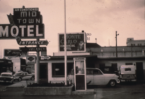
Slide of the Mid-Town Motel, Elko, Nevada, circa 1950
Date
1949 to 1951
Archival Collection
Description
An image of the Mid-Town Motel and its neon signs. Signs advertising the Monte Carlo are also visible.
Image
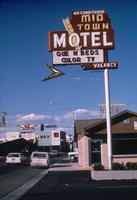
Slide of the Mid-Town Motel, Elko, Nevada, circa 1986
Date
1985 to 1987
Archival Collection
Description
An image of the neon sign for the Mid-Town Motel in Elko. The Thunderbird Motel sign is visible in the background.
Image
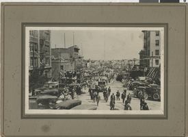
Photograph of crowds of people watching a parade, Tonopah, Nevada, circa 1910s
Date
1910 to 1919
Archival Collection
Description
Crowds of people line a street decorated with American flags in Tonopah, Nevada to watch a parade, probably for Independence Day. The Tonopah Club building is seen at left center.
Image

Slide of the Silver Dollar Club, Elko, Nevada, circa 1940s
Date
1940 to 1949
Archival Collection
Description
An image showing the exterior of the Silver Dollar Club, located at the intersection of Commercial Street and 4th Street in Elko. Snow is visible on the ground. Note: The left side of the image has faded.
Image