Search Results
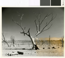
Photograph looking southeast through the remains of Saint Thomas, March 25, 1964
Date
Archival Collection
Description
Looking southeast through the remains of Saint Thomas with Lake Mead in the background.
Transcribed Notes: Bureau of Reclamation typed notes appended to back of photo: Townsite of St. Thomas, Nevada--Moapa Valley Project--Nevada A view of a portion of the townsite of St. Thomas, Nevada, settled by the Mormons in 1865, during a period of low water elevation in Lake Mead, above Hoover Dam. The town was first covered by Lake Mead in June 1938.
Image
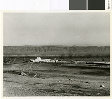
Photograph looking southeast through the remains of the post office in St. Thomas, Nevada, 1948
Date
Archival Collection
Description
The remains of the St. Thomas post office and Harry Gentry's store with Lake Mead in the background
Transcribed Notes: Bureau of Reclamation typed notes appended to back of photo: Boulder Canyon Project--Nevada--Region 3 St. Thomas, Nevada, was founded by the Mormons in 1855. In its heyday there were about 800 residents in the village. The "Main Street" was a part of the old Arrowhead Trail, which led from Salt Lake City, Utah to Los Angeles, California. In June 1938 the town was abandoned by its residents, which at that time were few in number because of the rising waters of Lake Mead that submerged the townsite. In 1945, after having been flooded for 7 years, receding waters of Lake Mead revealed St. Thomas much as it has appeared in former years. This photo was taken looking toward Mormon Mesa. The receding waters of the lake can be seen in the center of the photo.
Image

Photograph of pickers at work harvesting celery plants on the Iki Ranch near Logandale, Nevada, June 4, 1947
Date
Archival Collection
Description
Men harvesting celery on the Iki ranch near Logandale, Nevada.
Transcribed Notes: Bureau of Reclamation typed notes appended to back of photo: Boulder Canyon Project, Nevada Region 3 "Pickers" at work harvesting celery plants on the IKI Ranch near Logandale, Nevada. Raising celery plants is a relatively new type of irrigated specialty farming in southern Nevada. Water from the Muddy River is used to irrigate the fields. Twenty million celery plants were harvested from the 60 acres planted this season. The plants were shipped to the neighboring western states.
Image
Photograph of waterwheel on the Muddy River near Logandale, Nevada, January 21, 1947
Date
Archival Collection
Description
38 foot waterwheel on the Muddy River near Logandale, Nevada.
Transcribed Notes: Bureau of Reclamation typed notes appended to back of photo: Boulder Canyon Project, Nevada Region 3 A 38-foot water wheel lifts water 30 feet from the Muddy River to irrigate a farm near Glendale, Nevada.
Image
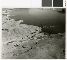
Photograph of flood damage recovery work on Nelson's Landing, September 1974
Date
Archival Collection
Description
Recovery operations at Nelson's Landing on the Colorado River after the 14 September 1974 Flood.
Transcribed Notes: Notes from photo sleeve: Nelson's Landing after the September 14, 1974 flood: salvage/recovery operations
Image
Photograph of flood damage recovery work on Nelson's Landing, circa September 1974
Date
Archival Collection
Description
Recovery operations at Nelson's Landing on the Colorado River after the 14 September 1974 Flood.
Transcribed Notes: Notes from photo sleeve: Nelson's Landing after the September 14, 1974 flood: salvage/recovery operations
Image
Photograph of Eldorado Canyon and Nelson's Landing after the September 1974 flood
Date
Archival Collection
Description
Eldorado Canyon and Nelson's Landing at the end of the cleanup after the 14 September 1974 Flood.
Image
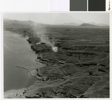
Aerial photograph of smoke from flood cleanup operations at Nelson's Landing, September 1974
Date
Archival Collection
Description
Smoke from three fires burning debris for cleanup operations after the 14 September 1974 flood at Nelson's Landing.
Image
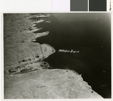
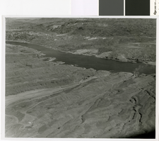
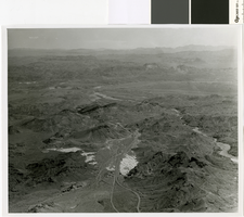
Aerial photograph of the flood path down Eldorado Canyon to Nelson's Landing, circa September, 1974
Date
Archival Collection
Description
Aerial view of the path of the flood down Eldorado Canyon to Nelson's Landing.
Image
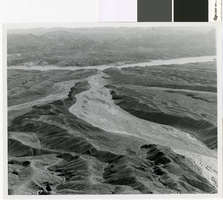
Aerial photograph of flood path, Eldorado Canyon to Nelson's Landing, September 14, 1974
Date
Archival Collection
Description
Aerial view of the path of the flood down Eldorado Canyon to Nelson's Landing.
Image