Search Results
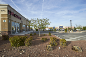
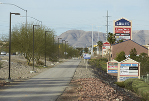
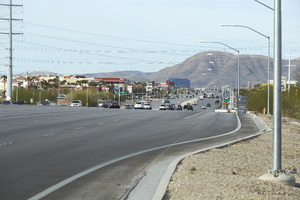
Landscaping and commercial development on Eastern Avenue south of Ione Road, looking south-southeast in Las Vegas, Nevada: digital photograph
Date
Archival Collection
Description
From the UNLV University Libraries Photographs of the Development of the Las Vegas Valley, Nevada (PH-00394). Part of the collection documents the entire 19 mile length of the north/south Eastern Avenue / Civic Center Drive alignment. This photograph was captured in the section of Eastern Avenue between Silverado Ranch Boulevard and Coronado Center Drive.
Image
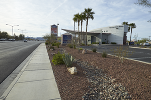
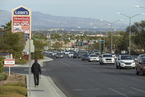
A Chick-fil-A fast food restaurant on Eastern Avenue at Ione Road, looking north-west in Las Vegas, Nevada: digital photograph
Date
Archival Collection
Description
From the UNLV University Libraries Photographs of the Development of the Las Vegas Valley, Nevada (PH-00394). Part of the collection documents the entire 19 mile length of the north/south Eastern Avenue / Civic Center Drive alignment. This photograph was captured in the section of Eastern Avenue between Silverado Ranch Boulevard and Coronado Center Drive.
Image
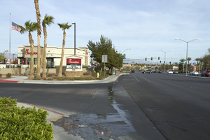
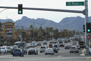
Commercial center along Eastern Avenue near St. Rose Parkway, looking southwest in Las Vegas, Nevada: digital photograph
Date
Archival Collection
Description
From the UNLV University Libraries Photographs of the Development of the Las Vegas Valley, Nevada (PH-00394). Part of the collection documents the entire 19 mile length of the north/south Eastern Avenue / Civic Center Drive alignment. This photograph was captured in the section of Eastern Avenue between Silverado Ranch Boulevard and Coronado Center Drive.
Image
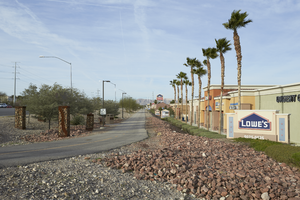
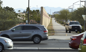
A portion of the St. Rose Parkway Trail next to commercial development as seen from Eastern Avenue, looking south-southwest in Las Vegas, Nevada: digital photograph
Date
Archival Collection
Description
From the UNLV University Libraries Photographs of the Development of the Las Vegas Valley, Nevada (PH-00394). Part of the collection documents the entire 19 mile length of the north/south Eastern Avenue / Civic Center Drive alignment. This photograph was captured in the section of Eastern Avenue between Silverado Ranch Boulevard and Coronado Center Drive.
Image
A portion of the St. Rose Parkway Trail next to commercial development as seen near Eastern Avenue, looking southwest in Las Vegas, Nevada: digital photograph
Date
Archival Collection
Description
From the UNLV University Libraries Photographs of the Development of the Las Vegas Valley, Nevada (PH-00394). Part of the collection documents the entire 19 mile length of the north/south Eastern Avenue / Civic Center Drive alignment. This photograph was captured in the section of Eastern Avenue between Silverado Ranch Boulevard and Coronado Center Drive.
Image
A man walks past commercial development along Eastern Avenue near St. Rose Parkway, looking west-northwest in Las Vegas, Nevada: digital photograph
Date
Archival Collection
Description
From the UNLV University Libraries Photographs of the Development of the Las Vegas Valley, Nevada (PH-00394). Part of the collection documents the entire 19 mile length of the north/south Eastern Avenue / Civic Center Drive alignment. This photograph was captured in the section of Eastern Avenue between Silverado Ranch Boulevard and Coronado Center Drive.
Image
Traffic flows past commercial development along Eastern Avenue at St. Rose Parkway, looking east-southeast in Henderson, Nevada: digital photograph
Date
Archival Collection
Description
From the UNLV University Libraries Photographs of the Development of the Las Vegas Valley, Nevada (PH-00394). Part of the collection documents the entire 19 mile length of the north/south Eastern Avenue / Civic Center Drive alignment. This photograph was captured in the section of Eastern Avenue between Silverado Ranch Boulevard and Coronado Center Drive.
Image
A portion of the St. Rose Parkway Trail next to residential housing as seen near Eastern Avenue, looking northeast in Las Vegas, Nevada: digital photograph
Date
Archival Collection
Description
From the UNLV University Libraries Photographs of the Development of the Las Vegas Valley, Nevada (PH-00394). Part of the collection documents the entire 19 mile length of the north/south Eastern Avenue / Civic Center Drive alignment. This photograph was captured in the section of Eastern Avenue between Silverado Ranch Boulevard and Coronado Center Drive.
Image
Traffic on St. Rose Parkway as seen from Eastern Avenue, looking southwest in Las Vegas, Nevada: digital photograph
Date
Archival Collection
Description
From the UNLV University Libraries Photographs of the Development of the Las Vegas Valley, Nevada (PH-00394). Part of the collection documents the entire 19 mile length of the north/south Eastern Avenue / Civic Center Drive alignment. This photograph was captured in the section of Eastern Avenue between Silverado Ranch Boulevard and Coronado Center Drive.
Image
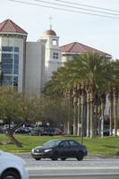
Dignity Health St. Rose Dominican Hospital on St. Rose Parkway as seen from near Eastern Avenue, looking south-southeast in Henderson, Nevada: digital photograph
Date
Archival Collection
Description
From the UNLV University Libraries Photographs of the Development of the Las Vegas Valley, Nevada (PH-00394). Part of the collection documents the entire 19 mile length of the north/south Eastern Avenue / Civic Center Drive alignment. This photograph was captured in the section of Eastern Avenue between Silverado Ranch Boulevard and Coronado Center Drive.
Image