Search Results
Photographs of house near Nivloc Mine (Nev.), 1930s
Date
1930 to 1939
Archival Collection
Description
House at site near Nivloc Mine. This house was moved to Tonopah, Nevada.
Image

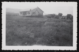
Photographs of house near Nivloc Mine, image 01
Date
1930 to 1939
Description
House from Nivloc Mine moved to Tonopah. Nivloc site where house picked up.
Image

Photographs of house near Nivloc Mine, image 02
Date
1930 to 1939
Description
Nivloc Mine house.
Image
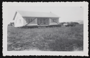
Photographs of house near Nivloc Mine, image 03
Date
1930 to 1939
Description
House brought from Nivloc Mine to Tonopah. The house was too heavy, so workers had to use dynamite to destroy the fireplace; it was too heavy.
Image

Photograph of bond used to raise money, Esmeralda County (Nev.), 1980
Date
1980
Archival Collection
Description
Photo of bond used to raise money to put in second water system with outside water. (First system, redwood pipe.) Esmeralda County, Nev.
Text
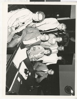
Photograph of public officials at the signing of a water bond, Esmeralda County (Nev.), 1972-1980
Date
1972 to 1980
Archival Collection
Description
Left to right standing:1): Andy Demetrius, Esmeralda County District Attorney; 2) Xenia Baird, Esmeralda County Clerk; 3) State Senator Rick Blakemore; 4)[Gov. Robert] List's press aide. Seated, left to right, 1) Eddy (Green Parrot Bar owner); 2) Gerry Allen, Esmeralda County Commissioner. Signing of water bond.
Image
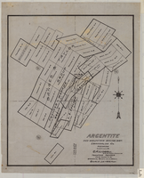
Map of Argentite: Red Mountain Mining District, Esmeralda County (Nev.),1908
Date
1908
Description
Scale [ca. 1:7,200]. 1 in. equals 600 feet ; 1 map : linen ; 46 x 39 cm
Image
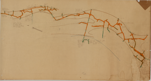
Map of the Red Top Mine, 4th level, Esmeralda County (Nev.), 1900-1925
Date
1900 to 1925
Description
Sectional mining map; hand-drawn and annotated in colored pencil
Image
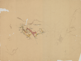
Map of the Combination Mine, 280 ft., Esmeralda County (Nev.), 1900-1925
Date
1900 to 1925
Description
Sectional mining map; hand-drawn and annotated in colored pencil
Image
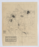
Map of Goldfield, circa 1904-1908
Date
1900 to 1912
Description
'This plat shows the principal mines of Goldfield. The five groups in which the Goldfield-Majestic Mines Company is interested are marked in black.'
Image