
Search the Special Collections and Archives Portal

Search Results

Display    Results Per Page
Displaying results 621 - 630 of 812

Map of California, with territories of Utah, Nevada, Colorado, New Mexico, and Arizona, 1864

Date

1864

Description

40 x 62 cm. Relief shown by hachures. Prime meridians: Greenwich and Washington. Page numbers at top: 58-59. "Entered according to act of Congress in the year 1864 by A. J. Johnson in the Clerk's Office of the District Court of the United States for the Southern District of New York." Original publisher: Johnson and Ward.

Image

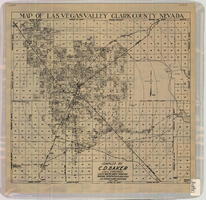
Map of Las Vegas Valley, Clark County, Nevada, October 1, 1940

Date

1940-10-01

Description

'Compiled by C.D. Baker, Civil Engineer, State Water Right Surveyor, Mineral Surveyor, Gen. Land Office, Las Vegas, Clark County, Nevada. Oct. 1, 1940.' Scale [ca. 1:48,000]. 1 in. to 4,000 ft. Cadastral map.

Image

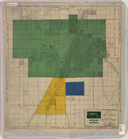
Map of Las Vegas and vicinity, Clark County, Nevada, April 15, 1951

Date

1951-04-15

Description

'2nd issue. 4/15/51.' 'Jack Asher, Reg. C.E. & Land Surveyor, Nev. #305.' Cadastral map..

Image

Redevelopment plan map for downtown Las Vegas, Nevada, November 18, 1987

Date

1987-11-18

Description

Scale [ca. 1:12,000. 1 inch equals approx. 1,000 feet]. 1 map ; on sheet 61 x 46 cm. "Nov. 18, 1987." "All land use designations on this map are to be interpreted in conformance with the community profiles component of the Las Vegas General Plan." City of Las Vegas?.

Image

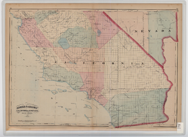
Map of southern California and southern Nevada, 1872

Date

1872

Description

'Entered according to Act of Congress in the year 1872 by Asher & Adams in the office of the Librarian of Congress at Washington.' Scale [ca. 1:1,267,300]. 1 in. to 20 miles (W 124°--W 114°/N 42°--N 32°). Shows natural features, populated places, county boundaries and railroads Prime meridians: Greenwich and Washington. In top margins: 95-96 (south portion). Shows range and township grid. Hand colored. Asher & Adams.

Image

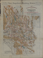
Map of California and Nevada deserts, 1905

Date

1905

Description

'Compiled by G.E. Bailey, E.M. Issued under the auspices of the the Los Angeles Chamber of Commerce and the supervision of its mining committee, Dan Murphy, H.Z. Osborne, Geo. W. Parsons, F.W. Braun, O.P. Posey, 1905.' 'A carefully prepared and authentic map of the desert mining region tributary of Los Angeles, embracing portions of Lincoln, Nye and Esmeralda counties, Nevada, showing location of all water supplies.' At top of page: 'Desert map. California-Nevada'. 'Miner's guide. Springs and waterholes.' Relief shown by hachures. Shows range and township grid. Scale indeterminable (W 119°--W 114°/N 37°--N 33°).

Image

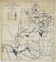
Map of Colorado River Basin, 1928

Date

1928

Description

52 x 46 cm. "Map no. 23000." Shows reservoir sites, irrigated areas, power plants, power sites, dam sites, national parks or monuments, and diversion from basin. Colorado River Basin/Department of the Interior, Bureau of Reclamation; John H. Pellen, chief draftsman. Original publisher: United States. Bureau of Reclamation.

Image

Topographic map of Cane Spring, Nevada quadrangle, 1961

Date

1961

Description

'Mapped, edited and published by the Geological Survey in cooperation with the Atomic Enegry Commission. Control by USGS, USC&GS, USCE, and Atomic Energy Commission. Topography from aerial photographs by photogrammetric methods. Aerial photographs taken 1959. Field check 1961.' Scale 1:24,000 polyconic projection (W 116°07'30"--W 116°00'00"/N 36°52'30"--N 36°45'00"). Series: 7.5 minute series (topographic). Relief shown by contours and spot heights. Contour interval 20 feet. Includes quadrangle location map. Interior--Geological SurveyFor sale by the U.S. Geological Survey

Image

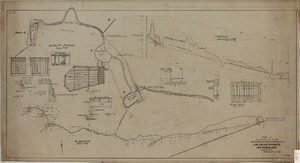
Map showing proposed improvement of Las Vegas Springs, Las Vegas, Nevada, September 21, 1916

Date

1916-09-21

Description

'Exhibit A'. 'Approved Sept. 21, 1916.' 'W.E.J.'"--Lower left corner. 'L-44-50 to 61. T-75 - 17 & 46'--Upper left corner. Includes discharge figures and plans for improvements to springs Scale [ca. 1:240]. 1 in. to 20 feet. -- Scale [ca. 1:2,400]. 1 in. to 200 ft. Vertical scale [ca. 1:48]. 1 in. to 4 feet. -- Scale [ca. 1:4,800]. 1 in. to 100 feet. Library's copy has "Proposed layout" written on it in pencil near lower center and other markings in red. Contents: Detail at springs -- Profile -- Alignment.

Image

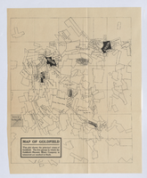
Map of Goldfield, circa 1904-1908

Date

1900 to 1912

Description

'This plat shows the principal mines of Goldfield. The five groups in which the Goldfield-Majestic Mines Company is interested are marked in black.'

Image