Search Results
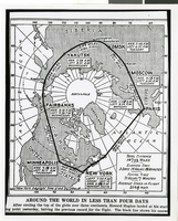
Photograph of a map showing the course of Howard Hughes' Round the World flight, circa 1938
Date
Archival Collection
Description
The black and white view of a map showing the path Howard Hughes took on his Round the World trip.
Image

Coyote Springs Investments Project Area: map
Date
Archival Collection
Description
From the Jeff Van Ee Papers (MS-00470) -- Coyote Springs development -- Maps file.
Image

Land Status Summary, Coyote Spring Investments: map
Date
Archival Collection
Description
From the Jeff Van Ee Papers (MS-00470) -- Coyote Springs development -- Maps file.
Image

Wildcat Wash NW, Nev. (Fish & Wildlife #1 WSA): map
Date
Archival Collection
Description
From the Jeff Van Ee Papers (MS-00470) -- Coyote Springs development -- Maps file.
Image

Wildcat Wash SW, Nev. (Fish & Wildlife #1 and #2 WSA): map
Date
Archival Collection
Description
From the Jeff Van Ee Papers (MS-00470) -- Coyote Springs development -- Maps file.
Image

Coyote Springs Valley Street Layout & Waters of the United States Crossings: map
Date
Archival Collection
Description
From the Jeff Van Ee Papers (MS-00470) -- Coyote Springs development -- Maps file.
Image

Coyote Springs Investments, LLC Golf Course Location: map
Date
Archival Collection
Description
From the Jeff Van Ee Papers (MS-00470) -- Coyote Springs development -- Maps file.
Image
Coyote Springs Investments, Soils Series: map
Date
Archival Collection
Description
From the Jeff Van Ee Papers (MS-00470) -- Coyote Springs development -- Maps file.
Image
Coyote Springs Investments, LLC Golf Course Location: map
Date
Archival Collection
Description
From the Jeff Van Ee Papers (MS-00470) -- Coyote Springs development -- Maps file.
Image
Coyote Springs Project Area – Waters of the United States: map
Date
Archival Collection
Description
From the Jeff Van Ee Papers (MS-00470) -- Coyote Springs development -- Maps file.
Image