
Search the Special Collections and Archives Portal

Search Results

Display    Results Per Page
Displaying results 201 - 210 of 253

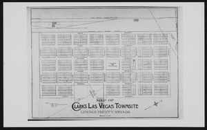
Clark's Las Vegas Townsite, Lincoln County, Nevada: map

Date

1900 (year approximate) to 1999 (year approximate)

Description

From the UNLV Libraries Single Item Accession Photograph Collection (PH-00171)

Image

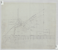
Elks Helldorado Grounds, Las Vegas, Nevada: map

Date

1934 (year approximate) to 1958 (year approximate)

Description

Map of Elks Helldorado Grounds in Las Vegas, Nevada. Map is from the Library's Union Pacific Collection, maps/drawings, Las Vegas Ranch folder 5A, drawing no. F-403. Scale approximately 1:2,400.

Image

Las Vegas SW quadrangle

Date

1973

Description

'Prepared by the U.S. Department of the Interior, Geological Survey, in cooperation with the U.S. Department of Housing and Urban Development, Federal Insurance Administration. 1973.'

Image

Las Vegas NW quadrangle

Date

1973

Description

'Prepared by the U.S. Department of the Interior, Geological Survey, in cooperation with the U.S. Department of Housing and Urban Development, Federal Insurance Administration. 1973.'

Image

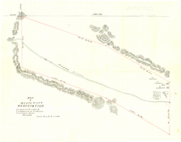
Map of Moapa River Reservation, located and surveyed by C. A. Bateman & A. J. Barnes, U.S. Indian agents, Nevada, 1875

Date

1875

Description

Scale 600 ft. to 1 inch. Relief shown by hachures. Shows buildings. Shows township and range grid. "Rec with Indian office letter June 10 1875. Copies sent to Sup. Gen. and R&R at Pioche Nevada August 9 1875" handwritten in blue ink on verso.

Image

Map of Moapa River Indian Reservation, TPS. 14 & 15 S., RS. 65 & 66 E., M.D.M., Nevada, 1902

Date

1902

Description

As surveyed by V. S. Barber, 1902. Scale = 15 chains to an inch. "H Doc 65 57 2" in lower right corner. Relief shown by hachures. Shows township and range grid.

Image

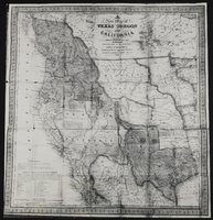
Map of Texas, Oregon, and California: map

Date

1846

Description

From the UNLV Libraries Single Item Accession Photograph Collection (PH-00171). Published by S. Augustus Mitchell, Philadelphia.

Image

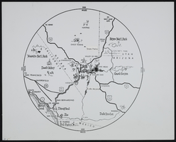
The Magic 300-Mile Circle Map: map

Date

1900 (year approximate) to 1999 (year approximate)

Description

From the UNLV Libraries Single Item Accession Photograph Collection (PH-00171). The Magic 300-Mile Circle. A map showing Las Vegas as the hub of a 300-mile circle containing the most significant tourist attractions in the southwestern United States.

Image

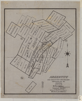
Map of Argentite: Red Mountain Mining District, Esmeralda County (Nev.),1908

Date

1908

Description

Scale [ca. 1:7,200]. 1 in. equals 600 feet ; 1 map : linen ; 46 x 39 cm

Image

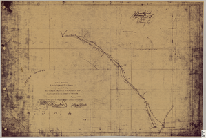
Map showing right of way of toll road constructed by Nevada Rapid Transit Co. in Lincoln County (Nev.), 1905

Date

1905

Description

Scale [ca. 126,720]. 1 in.=2 miles 1 map : blueline print ; 49 x 74 cmScale [ca. 126,720]. 1 in.=2 miles ; 1 map : blueline print ; 49 x 74 cm ; Shows right of way of what now is Interstate 95 through what is now Clark County, Nevada ; "Aug. 10, 1905." ; "Adopted as toll road of Nevada Rapid Transit Company at meeting of Board of Directors of said company Aug. 25, 1905. Attest Wh. Comstock, secretary, J. Ross Clark, president." ; "Book I, page 3"--Lower right corner of map ; "[Illegible] recording [illegible] J. Ross Clark September 1st. A.D. 1905 at 40 [illegible] 8 A in book of platts [illegible] Henry Lee [illegible]"--Upper right portion of map

Image