Search Results

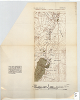
Map showing parts of eastern and southeastern Nevada and southwestern Utah, circa 1873
Date
Archival Collection
Description
Image
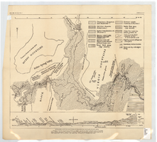
Topographic map of area near Virgin River south of St. Thomas, Nevada, 1936
Date
Archival Collection
Description
Image
Generalized geological map of the Boulder Reservoir floor and adjacent areas, 1936
Date
Archival Collection
Description
Image
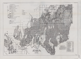
General geologic map of the Corners area, Arizona-Nevada-Utah, April 15, 1952
Date
Archival Collection
Description
Image
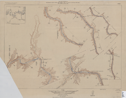
Map of plan and profile of Colorado River from Lees Ferry, Arizona to Black Canyon, Arizona-Nevada and Virgin River, Nevada, 1924
Date
Archival Collection
Description
Image
Graduation certificates and recognitions, 1914 to 1953
Level of Description
Archival Collection
Collection Name: Chester R. Longwell Professional Papers
Box/Folder: Oversized Box SH-078
Archival Component
Series I. Geological field notes, 1919 to 1971
Level of Description
Scope and Contents
The geological field notes series (1919-1971) consists of observations, sketches, and measurements taken by Chester Longwell on geological field trips, primarily in southern Nevada but also throughout the United States, the United Kingdom, South Africa, and Australia.
Archival Collection
Collection Name: Chester R. Longwell Professional Papers
Box/Folder: N/A
Archival Component
Series II. Manuscript materials, 1917 to 1974
Level of Description
Scope and Contents
The manuscript materials series (1917-1974) consists of Chester Longwell's handwritten and typed drafts of articles, speeches, and other written materials. The majority of the materials reference geological locations in southern Nevada, but also include articles on general geological topics, biographical memoirs, and several short fictional stories written by Longwell.
Archival Collection
Collection Name: Chester R. Longwell Professional Papers
Box/Folder: N/A
Archival Component
Series III. Published articles, 1923 to 1973
Level of Description
Scope and Contents
The published articles series (1923-1973) consists of reprints, offprints, and photocopies of articles and book chapters about geological topics written by Chester Longwell.
Archival Collection
Collection Name: Chester R. Longwell Professional Papers
Box/Folder: N/A
Archival Component
Series IV. Subject files, 1917 to 1972
Level of Description
Scope and Contents
The subject files series (1917-1972) series consists of papers from professional geological associations and societies, financial matters, business concerns, and personal and professional matters. Also included are educational materials related to courses Longwell taught at Yale University.
Archival Collection
Collection Name: Chester R. Longwell Professional Papers
Box/Folder: N/A
Archival Component