Search Results

Map showing parts of eastern and southeastern Nevada and southwestern Utah, circa 1873
Date
1869
1872 to 1873
Archival Collection
Description
Scale 1:506,880. 1 in. to 8 miles (W 117°30--W 114°45/N 37°20--N 40°00). Relief shown by hachures and spot heights. At top left: 'Explorations & surveys west of the one-hundredth meridian.' At top right: 'Parts of Eastern & Southeastern Nevada & Southwestern Utah. Atlas sheet number 66.' At bottom left: 'Expeditions of 1869, 1872 & 1873.' At bottom right: ' 1st Lieut. Geo. M. Wheeler, Corps of Engineers, com'd'g.' Seal of the War Department, Corps of Engineers, U.S. Army at top center of map. Originally published as part of the geological atlas which is an appendix to the Survey's Report upon United States geographical surveys west of the one hundredth meridian, published in 1876?
Image
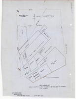
Plat showing cultivated land in the Stewart Ranch, Las Vegas, Nevada, December 8, 1902
Date
1902-12-08
Archival Collection
Description
'John T. McWilliams, U.S.M. Surveyor, Goodsprings, Nevada.' 'Dec. 8th 1902.' '60-A-Pt.II' handwritten in upper right corner. This is map of the Stewart Ranch, which was originally the Las Vegas Ranch, site of the Old Mormon Fort. Drawn with ink and colored pencil. Two holes punched on right side..
Image

Plat showing original townsite and subdivisions, Las Vegas, Lincoln County, Nevada, May 1905
Date
1905-05
Description
Land owned by the San Pedro, Los Angeles & Salt Lake Railroad is outlined. Scale: [ca. 1:12,000]. 1 inch = 1,000 feet. Cadastral map. Blueline print. Additional copy available in the J.T. McWilliams manuscript collection
Image

Blueprint showing proposed pipeline for gravity water supply at Las Vegas, Nevada, February 16, 1905
Date
1905-02-16
Description
'Office of Chief Engineer, Los Angeles, Cal., Feb. 16, 1905.' '2-18-17' hand-printed in lower right corner. Proposed pipeline is printed in red. Scale [1:6,000]. 1 inch to 500 feet. San Pedro, Los Angeles & Salt Lake Railroad Company. Office of Chief Engineer
Image

Map showing second stage plan of development for Southern Nevada Water Project, March 1981
Date
1981-03
Description
'United States Department of the Interior, Bureau of Reclamation.' 'June 1976. Revised March 1981.' 'Map No. 952-300-203.' 'Exhibit I.' Includes inset location map for project area. Scale [ca. 1:126,720. 1 in. to approx. 2 miles] . United States Department of the Interior, Bureau of Reclamation
Image
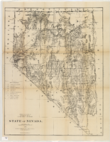
Map of Nevada, 1876
Date
1876
Description
'Compiled from the official records of the General Land Office and other sources by C. Roeser, principal draughtsman, G.L.O. Photo-lith & print. by Julius Bien, 16 & 18 Park Place, N.Y.' 'Department of the Interior, General Land Office, J.A. Williamson, Commissioner.' Scale [1:1,013,760]. 1 in. to 16 miles (W 120°--W 114°/N 42°--N 35°) .Relief shown by hachures. Shows township and range grid. Department of the Interior, General Land Office.
Image
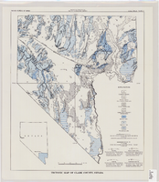
Tectonic map of Clark County, Nevada, 1965
Date
1965
Description
'Nevada Bureau of Mines. Bulletin 62, plate 5.' 'Prepared cooperatively by the U.S. Geological Survey.' Shows types of rocks as well as faults. Scale [ca. 1:760,320. 1 in. to approx. 12 miles] (W 116°--W 114°/N 37°--N 35°). Bulletin (Nevada Bureau of Mines)
62.
62.
Image
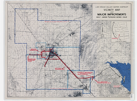
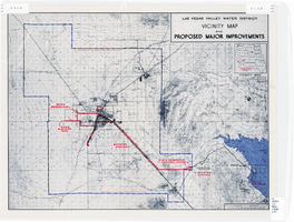
Map showing improvements made to the Las Vegas Valley Water District and vicinity under $8,700,000 bond issue,circa 1957
Date
1953 to 1961
Description
Relief shown by contour lines and spot heights. Includes inset location map of the Water District. Shows township and range grid. Boundary of Las Vegas Valley Water District marked in dark blue. 'Cole '57' in lower left corner. Scale [ca. 1:72,000. 1 in. to approx. 6,000 ft.]
Image
Map showing improvements made to the Las Vegas Valley Water District and vicinity, circa 1950
Date
1946 to 1954
Description
Relief shown by contour lines. Includes inset map showing the location of the Las Vegas Valley Water District Project. In lower left corner: 'Cole...O.' Boundary of Las Vegas Valley Water District marked in dark blue. Scale [ca. 1:126,720. 1 in. to approx. 2 miles
Image

Map of California, and territories of Utah, Nevada, Colorado, New Mexico and Arizona, 1864
Date
1864
Description
'Johnson's California, also Utah, Nevada, Colorado, New Mexico, and Arizona, published by A.J. Johnson, New York.' 'Entered according to act of Congress in the year 1864, by A.J. Johnson in the Clerks Office of the District Court of the United States for the southern district of New York.' Atlas page numbers in upper margin: 67-68. Relief shown by hachures. Prime meridian: Greenwich and Washington. Shows natural features, locations of Indian tribes, proposed railroad routes, routes of explorers, trails, county boundaries and populated places. Hand colored. On verso: 'Historical and statistical view of the West India Islands or Columbian Archipelago' (p. 80) and 'Historical and statistical view of Mexico and Central America' (p. 79). Scale [ca. 1:3,484,800]. 1 in. to ca. 55 miles (W 124°--W 102°/N 42°--N 32°).
Text