
Search the Special Collections and Archives Portal

Search Results

Display    Results Per Page
Displaying results 81 - 90 of 353

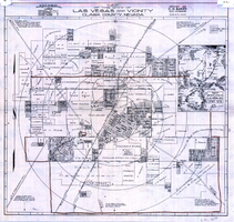
Map of the city of Las Vegas and vicinity, Clark County, Nevada, 1929

Date

1929

Description

'Copyright 1929, C.D. Baker, civil engineer. Drawn by R.C. Kenmir.' Includes inset sketch showing general location of Las Vegas, Nev. Relief shown pictorially on inset map. Scale [ca. 1:39,600. 1 in. to 0.625 mile]. Cadastral map. Library's copy 1 has hand-drawn brown line and red circles. Library's copy 2 has "Proposed annexation" printed in capital letters in red pencil near the top, has a brown line drawn around the area.

Image

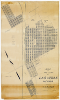
Map of the city of Las Vegas, Nevada, March 1, 1927

Date

1927-03-01

Description

'Compiled by C.D. Baker, civil eningeer. 220 Fremont St. March 1, 1927.' 'C.E. Pembroke, selling agent.' Scale [ca. 1:3,600]. 1 in. to 300 ft. Cadastral map. Blueline print.

Image

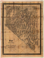
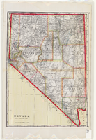
Map of the state of Nevada, 1886

Date

1886

Description

'Compiled by John W. Parker, chief draughtsman of the U.S. Sur. General's Office, Reno, Nevada, from official maps on file on the office, War Department maps and other reliable data. 1886.' 'Entered according to act of Congress, in the year 1886, by John W. Parker, in the office of the Librarian of Congress at Washington.' Relief shown by hachures. Shows townships, including which townships are subdivided, roads, railroads, Indian reservations, etc. Shows range and township grid. Scale [1:760,320]. 1 in. to 12 miles (W 120°--W 114°/N 42°--N 35°).

Image

Map of the state of Nevada to accompany the annual report of the Commr. Genl. Land Office, October 2, 1866

Date

1866-10-02

Description

'Department of the Interior, General Land Office, October 2nd, 1886, [signed] Jos. S. Wilson, Commissioner.' 'The Major & Knapp Eng. Mfg. & Lith. Co. 71 Broadway, N.Y.' Relief shown by hachures. Hand colored. Shows silver, gold, and copper mines. Scale [1:1,140,480]. 18 miles to an in. (W 120°--W 114°/N 42°--N 35°)

Image

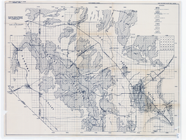
Map showing areas of bedrock and valley fill, drainage boundary, areas of artesian flow, and precipitation stations in the Las Vegas Valley area, 1946

Date

1946

Description

At top of map: 'United Sates Department of Interior, Geological Survey, Water Resources Bulletin no. 5, plate 2.' 'State Engiener of Nevada.' Relief shown by contours and spot heights. Scale [ca. 1:126,720. 1 inch to approx. 2 miles]

Image

Map showing detailed topography of the country traversed by the reconnaissance expedition through southern & southeastern Nevada, 1869 (reproduction)

Date

1869

Description

At top of map: 'Reconnaissance Maps, Department of California.' 'In charge of, Lieut. Geo. M. Wheeler, U.S. Engineers; assisted by Lieut. D.W. Lockwood, Corps of Engineers,U.S.A., 1969.' 'P.W. Hamel, chief topographer and draugthsman.' 'Traced 11-13-67.' 'BGS'; the G is enclosed in an arrowhead shape. 'Officially compiled and published at the Engineer Office, Head Quarters Department of California in 1869 and 70 by order of Brigadier General E.O.C. Ord. Comm'dg. [signed] Geo. M. Wheeler, Lieutenant of Engineers In Charge, Head Quarters Dept. of Cal. Oct. 26th, 1870.' Includes information from railroad maps, the United States Geological Survey of the 40th parallel and from Lieutenant Ives' explorations along the Colorado. Map includes camps, astronomical stations, good and bad wagon roads, trails, springs, settlements, mining districts, state and county boundaries and the watershed between the Humboldt and Colorado Basin. Shows most of eastern half of Nevada. Relief shown by hachures and spot heights. Scale indeterminable. (W 117°00´--W 113°00´/N 41°45´--N 35°45´). Series: Reconnaissance maps. Military map / Department of California
no. 1. Reproduction. Map is printed in purple. Scale of original map: [1:760,320]. 1 in. to approx. 12 miles. Includes dots hand-colored with red pencil marking Indian rancherias.

Image

Map of the city of Las Vegas, Nevada, June 1, 1946

Date

1946-06-01

Description

Scale [ca. 1:9,600. 1 in. to approx. 800 ft.]. Cadastral map. 'Compiled by Pioneer Title Insurance &Trust Company.' 'By Jack Asher, State Nev. Reg. Engr. No. 305.' 'Issue 5, 6/1/46.' Includes indexes. Pioneer Title Insurance &amp
Trust Company

Image

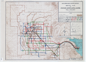
Topographic map of master plan for proposed water supply system for Las Vegas Valley Water District, August 1960

Date

1960-08

Description

Scale [ca. 1:63,360. 1 in. to approx. 1 mile]. Relief shown by contour lines. Includes inset location map of Water District. 'August 1960.' 'Plate 1.' Las Vegas Valley Water District

Image

Map of Nevada, circa 1909

Date

1907 to 1911

Description

'Geo. F. Cram, engraver and publisher.' Scale [ca. 1:1,584,000. 1 in. to approx. 25 miles] (W 120°--W 114°/N 42°--N 35°). Relief shown by hachures and spot heights. Counties outlined in color. Shows railroads, forest reserves, mines, Indian reservations, and springs. Shows range and township grid. Indexes on verso to both Nevada and Utah maps. Atlas p. numbers in right margin: 124-125. G.F. Cram.

Text

Original plat, townsite of Las Vegas, Lincoln Co., Nevada, January 13, 1905

Date

1905-01-13

Description

Subtitle: 'Embracing the N. 1/2 of S.W. 1/4 Sec. 27 Township 20S. R.61E. Mt. Diablo Meridian.' 'Book 1, page 17A" handwritten in lower right corner. Signed by Henry Lee, County Recorder, Lincoln County Nevada. 'Filed at request of J.T. Williams, January 13th A.D. 1905.' Backwards handwriting on right side. Map has a Lincoln County seal on the bottom near the center. In the dedication J.T. McWilliams states that he has surveyed and platted the townsite of Las Vegas subject to the right of way of the San Pedro, Los Angeles and Salt Lake Railroad Company. He signed the dedication on Jan. 13, 1905, and it was signed by witnesses Scale [ca. 1:2,520? 1 inch to approx. 210 feet?]. Copy of a blueline print.

Image