Search Results
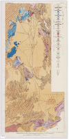
Geologic map of the Atomic Energy Commission Nevada Proving Grounds Area, Nye and Clark Counties, Nevada, 1952
Date
1952
Description
'At top of map: ' United States Department of the Interior. Geological Survey.' ' Bulletin 1021, Plate 32.' At bottom of map: 'Geology by Donald E. Hibbard and Mike S. Johnson, 1952.' 'Base from USAF Aeronautical Chart and Information Service, April 1952.' 'Interior--Geological Survey, Washington, D.C. MR-3767.' Scale 1:63,360 (W 116°10--W 115°55/N 37°15--N 36°40)
Geological Survey bulletin, 1021
Image
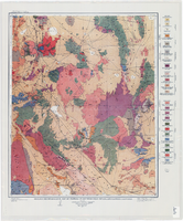
Geologic reconnaissance map of portions of southwestern Nevada and eastern California, 1905
Date
1905
Description
At top of map: 'U.S. Geological Survey, Charles D. Walcott, director.' At bottom of map: 'E.M. Douglas, Geographer. R.H. Chapman, in charge of section.Triangulation and topography by R.H. Chapman and B.D. Stewart. Surveyed in 1905.' 'Geology by Sydney H. Ball. Geology in immediate vicinity of Goldfield and Bullfrog generalized from maps by F.L. Ransome assisted by George H. Garrey and W.H. Emmons.' Scale 1:250,000 (W 117°30--W 116°/N 38°--N 36°)
Image
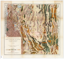
Geological reconnaissance map of Nevada south of the 40th parallel and adjacent California, 1903
Date
1903
Description
'Compiled from all available information by J.E. Spurr. Topographic base chiefly adapted from the maps of the Wheeler Survey.' 'U.S. Geological Survey, Bulletin No. 208, Pl. 1.' 'A. Hoen & Co. Lith. Baltimore, MD.' Relief shown by hachures and spot heights. Scale [ca. 1:950,000. 1 inch to approximately 15 miles] (W 120°--W 114°/N 40°--N 36°). Geological Survey bulletin, 208.
Image
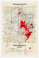
Map showing home-site lands in the Las Vegas Valley, 1955
Date
1955
Description
Scale [1:84,269. 1 in. to 1 1/3 miles] ; 1 map : col. ; 57 x 50 cm. on sheet 89 x 59 cm ; Cadastral map ; Gives definition of township, section and acre ; Relief shown by form lines and spot heights ; Shows private land, land classified for small tracts, leased land, vacant Federal land, section numbers, number of acres in each homesite and purchase price of tract ; "From your Congressman Cliff Young."--stamped on map ; Southern Nevada Home-Siters
Image

Map of California, Utah, Nevada, Colorado, New Mexico and Arizona, 1864
Date
1864
Description
'Johnson's California, also Utah, Nevada, Colorado, New Mexico, and Arizona, published by A.J. Johnson, New York.' 'Entered according to Act of Congress in the Year 1864, by A.J. Johnson in the Clerks Office of the District Court of the United States for the Southern District of New York.' Atlas page numbers in upper margin: 66-67. Relief shown by hachures. Prime meridians: Greenwich and Washington, D.C. Shows proposed railroads, locations of Indian tribes, natural features, counties, mines, mail routes, trails and routes of exploring expeditions. On verso: History and statistics of Mexico and Central America and statistics of national finances and the Post Office of the United States, 1860. Scale [ca. 1:3,484,800. 1 in. to ca. 55 miles] (W 123°--W 103°/N 42°--N 32°)
Text

Map of California and Territories of New Mexico and Utah, 1862
Date
1862
Description
Scale [ca. 1:3,231,360. 1 in. to approx. 51 miles] (W 125°00--W 103°30/N 42°00--N 31°45) ; 1 map : hand col. ; 40 x 60 cm., on sheet 46 x 68 cm ; Relief indicated by hachures and spot heights ; Prime meridians: Greenwich and Washington, D.C ; Decorative border ; Hand colored ; Atlas p. numbers in upper margin: 58-59 ; Date est. from territorial borders and county configuration ; Shows natural features, locations of Indian tribes, proposed railroad routes, routes of explorers, trails, county boundaries and populated places ; Johnson and Ward
Image

Map of California and territories of New Mexico and Utah, circa 1861
Date
1859 to 1862
Description
'Compiled, drawn, and engraved under the supervision of J.H. Colton and A.J. Johnson.' Relief shown by hachures and spot heights. Scale [ca. 1:3,041,280]. 1 in. to approx. 48 miles (W 124°--W 103°/N 42°--N 31°). Hand colored
Prime meridians: Greenwich and Washington
Plates 54 & 55 removed from Johnson's New illustrated family atlas of the world, with descriptions geographical, statistical and historical ... New York, 1862
Title page of atlas.
Prime meridians: Greenwich and Washington
Plates 54 & 55 removed from Johnson's New illustrated family atlas of the world, with descriptions geographical, statistical and historical ... New York, 1862
Title page of atlas.
Image

Map of the Las Vegas Strip, 1953
Date
1953
Description
Scale [ca. 1:9,600. 1 in. to approx. 800 ft.] ; 1 map : col. ; 57 x 29 cm ; Cadastral map ; Campbell Realty Company.
Image

Map of the Las Vegas Strip, May 1950
Date
1950-05
Description
Scale [ca. 1:10,200. 1 in. to approx. 850 ft.] ; 1 map : col. ; 54 x 28 cm ; Cadastral map ; "May 1950." Campbell Realty.
Image

Map of Las Vegas Valley showing artesian wells, circa 1920
Date
1918 to 1922
Description
Scale not given ; 1 map ; 66 x 55 cm ; Blueline print ; Cadastral map ; Includes township and range grid ; Includes quotations McWilliams?
Image