Search Results
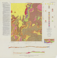
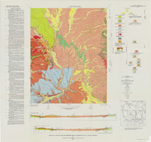
Geologic map of the Quartet Dome quadrangle, Nye County, Nevada, 1966
Date
1966
Description
58 x 46 cm., on sheet 88 x 85 cm., folded in envelope 30 x 24 cm. Relief shown by contours and spot heights. "Contour interval 20 feet." "Base by U.S. Geological Survey, 1962, 10,000-foot grid based on Nevada coordinate system, central zone." "Geology mapped in 1962-63." Includes 2 col. cross sections, diagrammetric stratigraphic section, quadrangle location map, and text. "Prepared in cooperation with the U.S. Atomic Energy Commission." Original publisher: Interior, Geological Survey, Series: Geologic quadrangle map GQ, Scale: 1:24 000.
Image
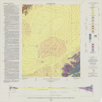
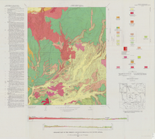
Geologic map of the Frenchman Flat quadrangle, Nye, Lincoln, and Clark Counties, Nevada, 1965
Date
1965
Description
58 x 47 cm., on sheet 81 x 81 cm., folded in envelope 30 x 24 cm. Relief shown by contours and spot heights. "Geology mapped in 1962. Contours on pre-Cenozoic rocks by D. L. Healey and C. H. Miller, 1958-63." Includes text, col. cross section and quadrangle location map. "Prepared in cooperation with the U.S. Atomic Energy Commission." Original publisher: Interior, Geological Survey, Series: Geologic quadrangle map GQ, Scale: 1:24 000.
Image
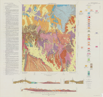
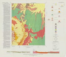
Geologic map of the Topopah Spring NW quadrangle, Nye County, Nevada, 1965
Date
1965
Description
58 x 47 cm., on sheet 84 x 89 cm., folded in envelope 30 x 24 cm. Relief shown by contours and spot heights. "Contour interval 20 feet." "Prepared in cooperation with the U. S. Atomic Energy Commission." "Geology mapped by R. L. Christiansen, P. W. Lipman, and H. R. Cornwall, 1962." Includes text, 3 col. cross sections, and quadrangle location map. Original publisher: Interior, Geological Survey, Series: Geologic quadrangle map GQ, Scale: 1:24 000.
Image
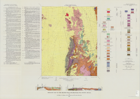
Geologic map of the Belted Peak quadrangle, Nye County, Nevada, 1967
Date
1967
Description
45 x 36 cm., on sheet 64 x 89 cm., fold. in envelope 30 x 24 cm. Relief shown by contours and spot heights. "Contour interval 40 feet." "Prepared in cooperation with the U.S. Atomic Energy Commission." "Geology mapped in 1962-63." Includes text, 2 col. cross sections, and quadrangle location map. Original publisher: U.S. Geological Survey, Series: Geologic quadrangle map GQ, Scale: 1:62 500.
Image
Geologic map of the Buckboard Mesa quadrangle, Nye County, Nevada, 1966
Date
1966
Description
58 x 46 cm., on sheet 87 x 91 cm., folded in envelope 30 x 24 cm. Relief shown by contours and spot heights. "Contour interval 20 feet." "Prepared in cooperation with the U.S. Atomic Energy Commission." "Geology mapped in 1962-63." Includes text, 2 col. cross sections, and 2 index maps. Original publisher: U.S. Geological Survey, Series: Geologic quadrangle map GQ, Scale: 1:24 000.
Image
Geologic map of the Thirsty Canyon quadrangle, Nye County, Nevada, 1966
Date
1966
Description
57 x 46 cm., on sheet 83 x 91 cm., folded in envelope 30 x 24 cm. Relief shown by contours and spot heights. "Geology mapped in 1963." Includes 2 colored cross sections, index map, text, and quadrangle location map. "Prepared in cooperation with the U. S. Atomic Commission." Original publisher: Interior, Geological Survey, Series: Geologic quadrangle map GQ, Scale: 1:24 000.
Image
Geologic map of the Trail Ridge quadrangle, Nye County, Nevada, 1968
Date
1968
Description
58 x 46 cm., on sheet 79 x 91 cm., folded in envelope 30 x 24 cm. Relief shown by contours and spot heights. "Prepared in cooperation with the U.S. Atomic Energy Commission." "Base by U.S. Geological Survey, 1962." "Geology mapped in 1963." "Contour interval 20 feet." Includes text, 2 col. cross sections, quadrangle location map, and 1 index map. Original publisher: Interior, Geological Survey, Series: Geologic quadrangle map GQ, Scale: 1:24 000.
Image
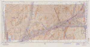
Elko sectional aeronautical chart, September 29, 1959
Date
1959-09-29
Description
52 x 110 cm. Relief shown by gradient tints, contours, and spot heights. Contour interval 1,000 feet. "Aeronautical data on this chart includes data received through Sept. 29, 1959." "Consult appropriate NOTAMS and Radio Facility Charts for supplemental data and current information." "Next edition is scheduled in approximately one year." "Base: Edition of May 1956. Revised Sept. 1958." "Lambert Conformal Conic Projection." "Standard Parallels 33° and 45°." "Elko compiled and printed at Washington, D. C. by the U. S. Coast and Geodetic Survey under authority of the Secretary of Commerce." "Principal sources: U. S. Geological Survey, U. S. Army Corps of Engineers, U. S. Air Force, U. S. Dept. of Agriculture, Civil Aeronautics Administration, and the U. S. Coast and Geodetic Survey." "Base: Edition of May 1956, revised Sept. 1958." "Detailed airport data and other useful information are printed on the back of this chart." Includes text, gradient tints scale and index to adjoining sheets. On verso: text, index map of sectional charts, inset maps of U.S. air defense identification zones and defense area, visual emergency signals, and charts. Original publisher: U.S. Coast and Geodetic Survey, Scale: 1:500,000.
Image
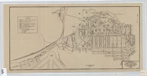
Cadastral map of Boulder City, Nevada, 1940
Date
1905-04-23
Description
A. M. S. Jan. 1940 in the lower left-hand corner. 1 map ; 61 x 30 cm. Cadastral map. "No. 40-1" in the lower right-hand corner. Shows block and lot numbers, buildings, water supply and sewage system, leased areas.
Image
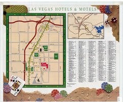
Map of Las Vegas hotels & motels, June 1990
Date
1990-06
Description
Color; 33 x 27 cm. on sheet 46 x 55 cm., folded to 23 x 10 cm. Panel title: Las Vegas area map. Shows locations of hotel and motels in the area of the Strip and Downtown. Also shows locations of country clubs. Includes a separate map of locations of hotels and motels in the surrounding area including North Las Vegas. Includes index. "LVM-75M-6/90."--Verso. Map of locations of golf courses on the verso along with information on points of interest, attractions, general information, tennis, bowling, recreational vehicle parks, and golf.
Image