Search Results
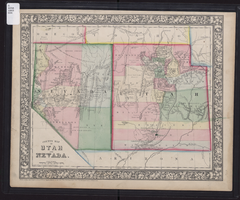
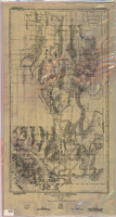
County map of Utah and Nevada, 1865
Date
1865
Description
'Entered according to Act of Congress in the year 1865 by S. Augustus Mitchell, Jr. in the Clerk's office of the District Court of the U.S. for the Eastern District of Pennsylvania . Drawn and engraved by W.H. Gamble, Philadelphia.' Shows roads, overland telegraph route, and other features. Relief shown by hachures and spot heights. Prime meridians: Greenwich and Washington. Scale [ca. 1:2,787,840] (W 120°--W 109°/N 43°--N 36° 59?).
Image
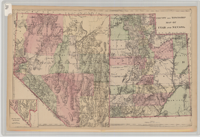
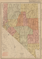
County and township map of Utah and Nevada, 1881
Date
1881
Description
'Entered according to Act of Congress in the year 1881 by S. Augustus Mitchell in the Office of the Librarian of Congress at Washington.' Relief shown by hachures. Prime meridians: Greenwich and Washington. In upper-right corner: 91. Shows range and township grid. Includes inset of southern portion of Nevada Scale [ca. 1:1,750,000]. 1 in. to approx. 27 miles (W 120°--W 109°/N 42°--N 35°).
Image
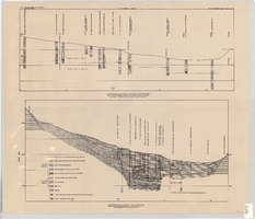
Cross-sections of wells and aquifers in the Las Vegas Valley, circa 1946
Date
1943 to 1949
Description
2 map sections on 1 sheet. Originally published as plate 6 in Geology and water resources of Las Vegas, Pahrump, and Indian Spring Valleys, Clark and Nye Counties, Nevada by George B. Maxey and C.H. Jameson, which is number 5 of the Water resources bulletin published by the Nevada Office of the State Engineer. Shows permeable and impermeable materials, wells, and aquifers.
Text
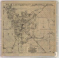
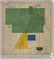
Map of Las Vegas Valley, Clark County, Nevada, October 1, 1940
Date
1940-10-01
Description
'Compiled by C.D. Baker, Civil Engineer, State Water Right Surveyor, Mineral Surveyor, Gen. Land Office, Las Vegas, Clark County, Nevada. Oct. 1, 1940.' Scale [ca. 1:48,000]. 1 in. to 4,000 ft. Cadastral map.
Image
Map of Las Vegas and vicinity, Clark County, Nevada, April 15, 1951
Date
1951-04-15
Description
'2nd issue. 4/15/51.' 'Jack Asher, Reg. C.E. & Land Surveyor, Nev. #305.' Cadastral map..
Image

Redevelopment plan map for downtown Las Vegas, Nevada, November 18, 1987
Date
1987-11-18
Description
Scale [ca. 1:12,000. 1 inch equals approx. 1,000 feet]. 1 map ; on sheet 61 x 46 cm. "Nov. 18, 1987." "All land use designations on this map are to be interpreted in conformance with the community profiles component of the Las Vegas General Plan." City of Las Vegas?.
Image
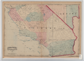
Map of southern California and southern Nevada, 1872
Date
1872
Description
'Entered according to Act of Congress in the year 1872 by Asher & Adams in the office of the Librarian of Congress at Washington.' Scale [ca. 1:1,267,300]. 1 in. to 20 miles (W 124°--W 114°/N 42°--N 32°). Shows natural features, populated places, county boundaries and railroads Prime meridians: Greenwich and Washington. In top margins: 95-96 (south portion). Shows range and township grid. Hand colored. Asher & Adams.
Image
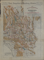
Map of California and Nevada deserts, 1905
Date
1905
Description
'Compiled by G.E. Bailey, E.M. Issued under the auspices of the the Los Angeles Chamber of Commerce and the supervision of its mining committee, Dan Murphy, H.Z. Osborne, Geo. W. Parsons, F.W. Braun, O.P. Posey, 1905.' 'A carefully prepared and authentic map of the desert mining region tributary of Los Angeles, embracing portions of Lincoln, Nye and Esmeralda counties, Nevada, showing location of all water supplies.' At top of page: 'Desert map. California-Nevada'. 'Miner's guide. Springs and waterholes.' Relief shown by hachures. Shows range and township grid. Scale indeterminable (W 119°--W 114°/N 37°--N 33°).
Image
Rand-McNally new commercial atlas map of Nevada, 1912
Date
1912
Description
Original publisher: Rand, McNally & Co. Scale [ca. 1:1,203,840). 1 inch to 19 miles. Originally published as p. 316-317 of Rand McNally's commercial atlas of America. Title in right margin: Nevada : commercial atlas of America. Includes township and range grid. Includes index to Nevada railroads and index to principal cities with their populations. Index on verso to counties, towns and natural features in Oregon and Nevada.
Image
Map of a part of southern Nevada showing ground-water conditions, 1914
Date
1914
Description
At bottom of map: 'Base compiled from plane-table sheets, topographic maps of U.S. Geological Survey, railroad alignments, and General Land Office data.' Relief shown by hachures and spot heights. Shows township and range grid. Covers from southeast corner of White Pine County to Sloan and from Nye County border to Arizona-Utah border. Shows flowing wells, nonflowing wells, springs, flowing-well areas, dry holes and shore lines of ancient lakes. Scale 1:500,000 (W116°--W 114°/N 45°--N 36°). Series: Water-supply paper (Washington, D.C.), 365. Map is plate 1 from the U.S. Geological Survey water-supply paper 365.
Image