Search Results

Report on the property of Goldfield Belmont Extension Mining Company, January 28, 1915
Date
1915-01-28
Archival Collection
Description
Report on the property of Goldfield Belmont Extension Mining Company, January 28, 1915
Text

The El Dorado Mining District Record Book G, May 13, 1913
Date
1913-05-13
Description
The El Dorado Mining District Record Book G, May 13, 1913
Text
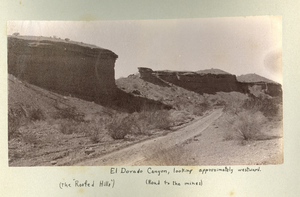
Photograph of Roofed Hills and the road to the mines, Eldorado Canyon (Nev.), 1900-1925
Date
1900 to 1925
Description
Caption: El Dorado Canyon, looking approximately westward. (the Roofed Hills) (Road to the mines)
Image
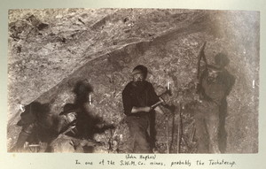
Photograph of miners inside the Techatticup Mine (Nev.), 1900-1925
Date
1900 to 1925
Description
Caption: (John Hughes) In one of the S.W.M. Co. mines, probably the Techatecup
Image
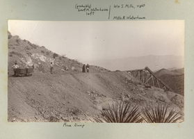
Photograph of a mine dump, Eldorado Canyon (Nev.), 1900-1925
Date
1900 to 1925
Description
Caption: (probably) Leof M. Waterhouse left/ Wm S. Mills, right Mills N. Waterhouse, Mine Dump
Image
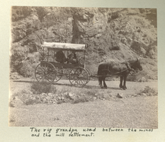
Photograph of a covered wagon on a dirt road, Eldorado Canyon (Nev.), 1900-1925
Date
1900 to 1925
Description
Caption: The rig grandpa used between the mines and the mill settlement.
Image
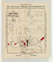
Map of the Bullfrog Mining District, Nye County (Nev.), 1905
Date
1905
Description
Scale [ca. 1:39,000. 1 in. to approx. 3,250 feet] ; 1 map : col. ; 45 x 38 cm ; Relief shown by hachures ; "Compliments of the Forward Mining Development Co." ; Properties owned by Patrick Investment Company are marked in red ; Shows railroads, roads, and pipelines ;
Image
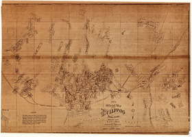
New official map of the Bullfrog Mining District, Nye County (Nev.), 1905
Date
1905
Description
Scale [ca. 1:16,800. 1 inch to approximately 1,400 feet] ; 1 map ; 74 x 109 cm ; Blueline print ; Scale almost illegible ; "Photo. lith. Britton & Rey." ; Photocopy? [United States : s.n., 199-?] ;
Image
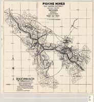
Map of the Pioche mines, Ely Mining District, Lincoln County (Nev.), 1909
Date
1909
Description
Scale unreadable ; 1 map ; 42 x 40 cm ; Photocopy. [United States ; s.n., 198-?] ; Includes township and range grid ; Includes wagon roads ;
Image
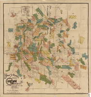
Elmer J. Chute's Map of Goldfield Mining District, Esmeralda and Nye Counties (Nev.), 1905
Date
1905
Description
Scale [ca. 1:20, 400. 1 in.=aprrox. 1,700 feet] ; 1 map : col. ; 60 x 58 cm ; Includes inset location map ; Includes township and range grid ;
Image