Search Results
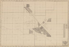
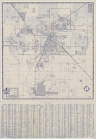
Map, city of Henderson, Nevada, August 1, 1955
Date
1955-08-01
Description
'Compiled by Pioneer Title Insurance & Trust Company.' '8/1/55.' Includes street index.
Image
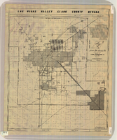
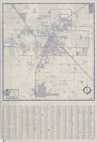
Map of Las Vegas Valley, Clark County, Nevada, circa 1950-1956
Date
1950 to 1956
Description
'Nevada Title Insurance Co. Compiled by Tyson Engineering Co. ... Las Vegas, Nevada. Drawn by A.A. Elliott, Jr.' Shows sewer, water, gas and power lines, water treatment facilities, steam plants, boundaries of the Las Vegas Valley Water District and the Clark County Sanitation District boundaries. Scale [ca. 1:63,360. 1 in. to approx. 1 mile].
Image

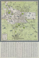
Official Arrow city map, Las Vegas & vicinity, Nevada, circa 1957-1961
Date
1957 to 1961
Description
71 x 68 cm. on sheet 106 x 71 cm., folded in cover 25 x 12 cm. Cover title: Latest edition, city map and street index of "fabulous" Las Vegas and vicinity, Nevada. Publisher from cover. "H-654-32." Includes indexes. Inside of cover includes information on Las Vegas. Includes inset maps of Boulder City, Nevada, and Las Vegas's location. Original publisher: R. L. Polk.
Image

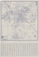
Map of Las Vegas and vicinity, Nevada, circa 1957-1961
Date
1957 to 1961
Description
70 x 68 cm. on sheet 106 x 71 cm. Includes indexes. Includes Nellis Air Force Base, Henderson, and inset maps of Boulder City, Nevada, and Las Vegas's geographical location in the Southwest. "H-654-32" on the lower right-hand corner. Page 2 contains a photograph of the Fremont Street in Downtown Las Vegas, featuring the Golden Nugget Gambling Hall and the Horseshoe Casino. Page 3 outlines local and regional attractions, as well as population information. Original publisher: R. L. Polk.
Image
Map of Las Vegas and vicinity, 1963
Date
1963
Description
42 x 39 cm., folded to 21 x 9 cm. Panel title: Las Vegas and southern Nevada map and street guide. Includes index. Includes illustrations . Advertisement for Nevada State Bank, text with facts about Las Vegas and maps of Henderson, Boulder City and downtown Las Vegas on verso. "Courtesy of Nevada State Bank."--Panel. Original publisher: Thomas Bros. Maps.
Image

Map of the city of Las Vegas, North Las Vegas, the "Strip", 1963
Date
1963
Description
39 x 36 cm., folded to 28 x 15 cm. Panel title: Welcome map, greater Las Vegas area and scenic routes to and from there. Copyright held by Robert E. Barringer. Includes advertisements for Las Vegas businesses, inset of map of Henderson, Nev., and index. Map of California from San Francisco to Los Angeles to Las Vegas by Beth Bergh, advertisements and index on verso Christmas ed. Greater Las Vegas, 1963-1964 ed. Original publisher: Redwood Publishing Co..
Image
Street map of Las Vegas and vicinity, 1962
Date
1962
Description
43 x 40 cm., folded to 18 x 9 cm. Panel title: Las Vegas and vicinity. "Richfield" below title." Includes index. Text with facts about Las Vegas, photographs of Las Vegas and nearby tourist attractions and maps of Henderson, Boulder City and downtown Las Vegas on verso. Original publisher: Thomas Bros. Maps, Scale: One inch equals approximately 0.68 mile.
Image
Street map of Las Vegas and vicinity, 1961
Date
1961
Description
43 x 40 cm., folded to 18 x 9 cm. Panel title: Las Vegas and vicinity map. Includes index. Text with facts about Las Vegas, photographs of Las Vegas and nearby tourist attractions and maps of Henderson, Boulder City and downtown Las Vegas on verso. Library's copy 2 has notes handwritten in black ink. Original publisher: Thomas Bros. Maps, Scale: One inch equals approximately 0.68 mile.
Image
Street map of Las Vegas and vicinity, 1960
Date
1960
Description
43 x 40 cm., folded to 18 x 9 cm. Panel title: Las Vegas and vicinity map. Includes index. Text with facts about Las Vegas, photographs of Las Vegas and nearby tourist attractions and maps of Henderson, Boulder City and downtown Las Vegas on verso. Library's copy 2 has notes handwritten in black ink. Original publisher: Thomas Bros. Maps.
Image
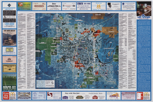
Aerial map of the Las Vegas Valley, with map of Las Vegas, 1992
Date
1992
Description
2 maps on 1 sheet : both sides, col. ; 47 x 51 cm. and 54 x 71 cm. on sheet 61 x 91 cm. Photomap. Includes text about Las Vegas, list of businesses with coordinates for map on verso, and advertisements. On verso: Bird's-eye view map of a section of unincorporated Las Vegas east of the Strip between Charleston and Sunset oriented with north to left and drawn by Jack Tavenner in 1992. Shows locations of schools, lists Boulder City merchants, and includes advertisements. Original Publisher: Landiscor Aerial Photo
Image